
ทางหลวงรัฐเวอร์จิเนียหมายเลข 80
 ทางหลวงรัฐหมายเลข 80 | ||||
|---|---|---|---|---|
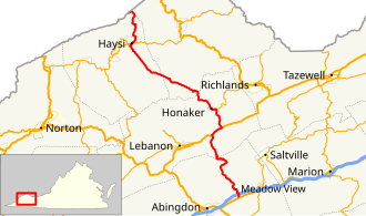 SR 80 ที่ไฮไลต์ด้วยสีแดง | ||||
| ข้อมูลเส้นทาง | ||||
| ดูแลรักษาโดยVDOT | ||||
| ความยาว | 67.37 ไมล์[ 1 ] [ 2 ] [ 3 ] [ 4 ] (108.42 กม.) | |||
| มีอยู่ | 1 กรกฎาคม พ.ศ. 2476 [ 5 ] – ปัจจุบัน | |||
| เส้นทางท่องเที่ยว |  เวอร์จิเนีย บายเวย์ เวอร์จิเนีย บายเวย์ | |||
| จุดเชื่อมต่อหลัก | ||||
| ฝั่งตะวันตก |  ทางหลวง KY 80ใกล้เมืองเอลค์ฮอร์น รัฐเคนตักกี้ ทางหลวง KY 80ใกล้เมืองเอลค์ฮอร์น รัฐเคนตักกี้ | |||
| สี่แยกสำคัญ |  SR 83ในHaysi US 19ที่Rosedale I-81ใกล้Meadowview SR 83ในHaysi US 19ที่Rosedale I-81ใกล้Meadowview  | |||
| ฝั่งตะวันออก |   ถนน US 11 / SR 803ใกล้กับ Meadowview ถนน US 11 / SR 803ใกล้กับ Meadowview | |||
| ที่ตั้ง | ||||
| ประเทศ | สหรัฐอเมริกา | |||
| สถานะ | เวอร์จิเนีย | |||
| เขตปกครอง | บูแคนัน , ดิคเคนสัน , รัสเซลล์ , วอชิงตัน | |||
| ระบบทางหลวง | ||||
| ||||

ทางหลวงรัฐหมายเลข 80เป็นทางหลวงสายหลักของรัฐในส่วนตะวันตกเฉียงใต้ของ รัฐ เวอร์จิเนียประเทศสหรัฐอเมริกาเริ่มต้นจาก เส้นแบ่งเขตแดนรัฐ เคนตัก กี้ ที่อุทยานแห่งรัฐเบรกส์ ไปทาง ตะวันออกจนถึงทางหลวงสหรัฐหมายเลข 11ใกล้กับเมืองเมโดว์วิว ทางหลวง รัฐเคนตักกี้หมายเลข 80และ ทางหลวง รัฐมิสซูรีหมายเลข 80ต่อเนื่องไปทางตะวันตกจนถึงเมืองแมทธิวส์ รัฐมิสซูรีตลอดทั้งสายของทางหลวงรัฐหมายเลข 80 เป็นส่วนหนึ่งของเส้นทางจักรยานสหรัฐหมายเลข 76
คำอธิบายเส้นทาง

เขตบูคานันและดิคเคนสัน
ทางหลวงหมายเลข 80 ของรัฐเคนตักกี้วิ่งเลียบแม่น้ำรัสเซลฟอร์กจากมิลลาร์ดไปจนเกือบถึงเส้นแบ่งเขตแดนรัฐเวอร์จิเนีย จากนั้นจะเลี้ยวไปทางทิศตะวันออกเฉียงเหนือเลียบฝั่งตะวันตกของลำธารกราสซีครีก ซึ่งอยู่ในรัฐเวอร์จิเนียและเป็นเส้นแบ่งเขตแดนระหว่างเทศมณฑลบูคานันและดิคเคนสัน เพื่อหลีกเลี่ยงหุบเหวลึกในอุทยานแห่งรัฐเบรกส์ทางหลวงหมายเลข 80 จะข้ามไปยังรัฐเวอร์จิเนียในไม่ช้า และยังคงขนานไปกับลำธารกราสซีครีกจนถึงทางแยกกับลำธารฮันท์สครีก ซึ่งทางหลวง (และเส้นแบ่งเขตเทศมณฑล) จะเลี้ยวไปทางทิศตะวันออกเฉียงใต้เพื่อเลียบไปตามลำธารนั้น ประมาณครึ่งทางไปยังชุมชนเบรกส์ทางหลวงหมายเลข 80 จะข้ามลำธารและเส้นแบ่งเขตเทศมณฑล
SR 80 passes the community of Breaks, leaving Hunts Creek there and running past the entrance to Breaks Interstate Park. It runs south through Camp Branch Gap, and then continues in a general southerly direction alongside small creeks and over two summits to State Route 83 east of Haysi. SR 80 and SR 83 overlap west alongside Russell Prater Creek into Haysi, where they meet State Route 63 at the point where Russell Prater Creek empties into the Russell Fork. The two routes turn south, but SR 83 soon splits to the west to follow the McClure River. SR 80 continues southeasterly along the Russell Fork past Martha Gap and Birchleaf to the point where the Russell Fork turns east; SR 80 continues next to Fryingpan Creek past Colley, then alongside Priest Fork to Sportsman Lake and through Abner Gap to the Abner Branch, rejoining the Russell Fork at Bee.
SR 80 and the Russell Fork continue past Davenport and Council. The fork ends as the road approaches Sandy Ridge and the Tennessee Valley Divide, which it climbs Big A Mountain via a series of hairpin curves.
Russell County
SR 80 descends from Big A Mountain into a relatively flat area, where it runs cross-country and next to small creeks via Honaker, the junction with State Route 67, and a bridge over the Clinch River at Blackford to U.S. Route 19 at Rosedale. There it turns southwest with US 19, alongside Elk Garden Creek, to Smithfield, where it splits to the south. SR 80 again runs cross-country past Rockdell, where it begins to climb Clinch Mountain, which it crosses (into Washington County) at Hayters Gap.
Washington County
SR 80 descends from Hayters Gap to the East Fork Wolf Creek. There it turns southwest, following the creek to the community of Hayters Gap, and then following Wolf Creek through a gap in Little Mountain to the North Fork Holston River at the community of River Bridge. It crosses the river and follows Logan Creek uphill to Lindell, where the land levels out. It continues to follow Logan Creek past Yellow Springs and Giesley Mill, then crossing a low summit to Meadow View. SR 80 crosses Interstate 81 at a Diamond interchange southeast of Meadowview, providing access on I-81, and then ends at U.S. Route 11 at Cedarville. State Route 803, formerly part of SR 80, continues southeast from Cedarville to Lodi.
History
The road from Lodi to Cedarville, now State Route 803, was planned as part of State Route 12, the predecessor to U.S. Route 58, in 1923.[6] The next year, however, SR 12 was realigned to pass through Damascus,[7] and the road from State Route 10 (now U.S. Route 11) at Cedarville towards Lodi for five miles (8 km) was added to the state highway system[8] as State Route 125, a spur of SR 12. The next year it was extended southeast the rest of the way to SR 12 at Lodi and northwest 1.1 miles (1.8 km) to Meadowview.[9]
Five miles (8 km) of road northwest from Meadowview and three miles (5 km) southeast from State Route 11 (now U.S. Route 19) near Rosedale were added to the state highway system in 1928 as State Route 111,[10] and SR 125 was renumbered as part of SR 111 that same year. The gap was closed in 1930 and 1931.[11]
Major intersections
| County | Location | mi[1][2][3][4] | km | Destinations | Notes |
|---|---|---|---|---|---|
| Buchanan | Breaks Interstate Park | 0.00 | 0.00 |  KY 80 west – Elkhorn City KY 80 west – Elkhorn City | Kentucky state line; western terminus |
| Dickenson | |  ทางหลวง หมายเลข 121 ของสหรัฐอเมริกา (ทางด่วนโคลฟิลด์) ทางหลวง หมายเลข 121 ของสหรัฐอเมริกา (ทางด่วนโคลฟิลด์) | จุดเชื่อมต่อที่เสนอ[ 12 ] | ||
| เฮย์ซี | 10.09 | 16.24 |  ทางหลวงหมายเลข 83ฝั่งตะวันออก (ทางหลวงดิคเคนสัน) – แวนแซนต์ , กรันดี ทางหลวงหมายเลข 83ฝั่งตะวันออก (ทางหลวงดิคเคนสัน) – แวนแซนต์ , กรันดี | ปลายด้านตะวันตกของเส้นทางที่เชื่อมต่อกับทางหลวงหมายเลข 83 (SR 83) | |
| 11.18 | 17.99 |   SR 63ทิศใต้ (ถนนสายหลัก Haysi) – เขื่อน John Flannagan SR 63ทิศใต้ (ถนนสายหลัก Haysi) – เขื่อน John Flannagan | จุดสิ้นสุดทางเหนือของทางหลวงหมายเลข 63 | ||
| 11.52 | 18.54 | ทางหลวงหมายเลข 83ฝั่งตะวันตก (ทางหลวงดิคเคนสัน) – คลินต์วูด , พาวด์ | ปลายด้านตะวันออกของเส้นทางที่เชื่อมต่อกับทางหลวงหมายเลข 83 (SR 83) | ||
| รัสเซลล์ | โฮนาเกอร์ | 39.09 | 62.91 |   ทางหลวงหมายเลข 67เหนือ (ถนนสวอร์ดส์ครีก) – สวอร์ดส์ครีก ทางหลวงหมายเลข 67เหนือ (ถนนสวอร์ดส์ครีก) – สวอร์ดส์ครีก | จุดสิ้นสุดทางใต้ของทางหลวงหมายเลข 67 |
| โรสเดล | 43.59 | 70.15 | ทางหลวง หมายเลข 19 ของสหรัฐฯมุ่งหน้าไปทางเหนือ – ทาเซเวลล์ , บลูฟิลด์ | จุดสิ้นสุดด้านตะวันตกของเส้นทางร่วมกับทางหลวงหมายเลข 19 ของสหรัฐฯ | |
| สมิธฟิลด์ | 46.16 | 74.29 | ทางหลวง หมายเลข 19 ของสหรัฐฯฝั่งใต้ – เลบานอน , บริสตอล | ปลายด้านตะวันออกของเส้นทางร่วมกับทางหลวงหมายเลข 19 ของสหรัฐฯ | |
| วอชิงตัน | เมโดว์วิว | 66.54 | 107.09 | ทางหลวง หมายเลข I-81 – โรอาโนค , บริสตอล | ทางออกที่ 24 ของทางหลวงหมายเลข I-81 |
| ซีดาร์วิลล์ | 67.37 | 108.42 | ทางหลวง หมายเลข 11 ของสหรัฐอเมริกา (Lee Highway) / ทางหลวง หมายเลข 803 ของรัฐ (Cedar Creek Road) – Chilhowie , Abingdon | สถานีปลายทางด้านตะวันออก | |
1.000 ไมล์ = 1.609 กม.; 1.000 กม. = 0.621 ไมล์
| |||||
ลิงก์ภายนอก

- โครงการทางหลวงเวอร์จิเนีย: VA 80