
รายชื่อเขตปกครองในรัฐวอชิงตัน

| เขตปกครองของวอชิงตัน | |
|---|---|
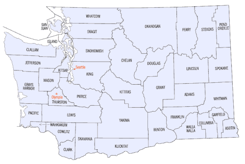 | |
| ที่ตั้ง | รัฐวอชิงตัน |
| ตัวเลข | 39 |
| ประชากร | 2,416 ( การ์ฟิลด์ ) – 2,344,939 ( คิง ) |
| พื้นที่ | 175 ตารางไมล์ (450 ตาราง กิโลเมตร) ( ซานฮวน ) – 5,268 ตารางไมล์ (13,640 ตารางกิโลเมตร) ( โอคาโนแกน ) |
| รัฐบาล | |
| การแบ่งย่อย |
|
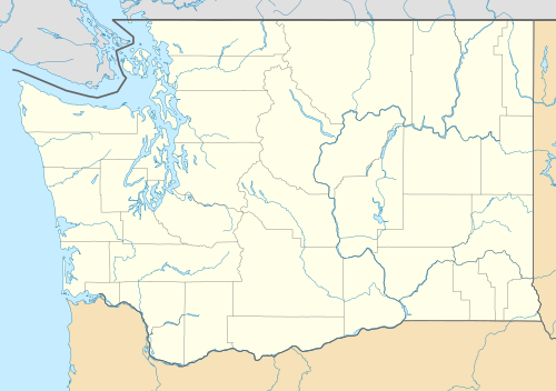
รัฐวอชิงตันของสหรัฐอเมริกามี 39 เคาน์ตีรัฐบาลชั่วคราวแห่งโอเรกอนได้ก่อตั้ง เคาน์ ตีแวนคูเวอร์และลูอิส ขึ้น ในปี 1845 ในดินแดนโอเรกอนที่ยังไม่มี การจัดระเบียบ ซึ่งทอดยาวจากแม่น้ำโคลัมเบียไปทางเหนือจนถึงละติจูด 54°40′ เหนือหลังจากที่ภูมิภาคนี้ได้รับการจัดระเบียบภายในดินแดนโอเรกอนโดยมีพรมแดนทางเหนือปัจจุบันอยู่ที่ละติจูด 49° เหนือ เคาน์ตีแวนคูเวอร์จึงเปลี่ยนชื่อเป็นเคาน์ตีคลาร์กและมีการจัดตั้งเคาน์ตีเพิ่มอีก 6 เคาน์ตีจากเคาน์ตีลูอิสก่อนการจัดตั้งดินแดนวอชิงตันในปี 1853 มีเคาน์ตีทั้งหมด 28 เคาน์ตีที่ก่อตั้งขึ้นในช่วงที่วอชิงตันเป็นดินแดน โดยสองเคาน์ตีในจำนวนนี้มีอยู่เพียงช่วงสั้นๆ เคาน์ตีอีก 5 เคาน์ตีสุดท้ายก่อตั้งขึ้นใน 22 ปีหลังจากที่วอชิงตันได้รับการยอมรับเข้าเป็นรัฐที่ 42 ของสหรัฐอเมริกาในปี 1889 [ 1 ] [ 2 ]
Article XI of the Washington State Constitution addresses the organization of counties. New counties must have a population of at least 2,000 and no county can be reduced to a population below 4,000 due to partitioning to create a new county.[3] To alter the area of a county, the state constitution requires a petition of the "majority of the voters" in that area. A number of county partition proposals in the 1990s interpreted this as a majority of people who voted, until a 1998 ruling by the Washington Supreme Court clarified that they would need a majority of registered voters.[4] No changes to counties have been made since the formation of Pend Oreille County in 1911, except when the small area of Cliffdell was moved from Kittitas to Yakima County in 1970.[5]
King County, home to the state's largest city, Seattle, holds almost 30% of Washington's population (2,344,939 residents of 8,001,020 in 2025), and has the highest population density, with more than 1,000 people per square mile (400/km2). Garfield County is both the least populated (2,416) and least densely populated (3.4/sq mi [1.3/km2]). Two counties, San Juan and Island, are composed only of islands. The average county is 1,830 square miles (4,700 km2), with 205,154 people.
Seventeen counties have Native American–derived names, including nine names of tribes whose land settlers would occupy. Another seventeen were named for political figures, only five of whom had lived in the region. The last five are named for geographic places.[6]
The Federal Information Processing Standard (FIPS) code, used by the United States government to uniquely identify counties, is provided with each entry. The FIPS code links in the table point to U.S. Census data pages for each county. Washington's FIPS state code is 53.
Governance
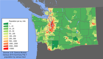
Counties provide a broad scope of services, including court operation, parks and recreation, libraries, arts, social services, elections, waste collection, roads and transportation, zoning and permitting, as well as taxation.[7][8] The extent of these vary, and some are administered by municipalities. Counties are not subdivided into minor civil divisions like townships; sub-county local government is only by incorporated cities and towns, as well as by 29 Indian reservations, while unincorporated areas are governed only by the county. There are 242 census county divisions for statistical purposes only.[9]
The default form of county government is the non-charter commission, with three to five elected commissioners serving as both the legislature and executive. Seven counties have adopted charters providing for home rule distinct from state law: King, Clallam, Whatcom, Snohomish, Pierce, San Juan, and Clark. Of these, King, Whatcom, Snohomish, and Pierce, four major counties on Puget Sound, elect a county executive. Councils in the other three charter counties appoint a manager to administer the government.[10] Voters may also elect a clerk, treasurer, sheriff, assessor, coroner, auditor (or recorder), and prosecuting attorney. Elections are nonpartisan in non-charter counties, but charter counties may choose to make some positions partisan, though all elections are by top-two primary.[10]
List of counties
| County | FIPS code | County seat[11] | Est.[11][12] | Formed from[12][13] | Etymology | Population(2025)[14] | Land area[11] | Map |
|---|---|---|---|---|---|---|---|---|
| AdamsCounty | 001 | Ritzville | 1883 | Whitman County | John Adams (1735–1826), 2nd U.S. President[15] | 21,488 | 1,925 sq mi(4,986 km2) |  |
| AsotinCounty | 003 | Asotin | 1883 | Garfield County | The Nez Percé name for Eel Creek[16] | 22,545 | 636 sq mi(1,647 km2) |  |
| BentonCounty | 005 | Prosser | 1905 | Yakima and Klickitat Counties | โทมัส ฮาร์ท เบนตัน (1782–1858) สมาชิกวุฒิสภาสหรัฐฯ จากรัฐมิสซูรี[ 17 ] | 221,722 | 1,700 ตาราง ไมล์( 4,403 ตาราง กิโลเมตร) |  |
| เทศมณฑลเชแลน | 007 | เวนาชี | 1899 | เขตโอคาโนแกนและ เขตคิตทิตัส | คำ ภาษา พื้นเมืองอเมริกันที่มีความหมายว่า "น้ำลึก" หมายถึงทะเลสาบเชลาน[ 18 ] | 81,941 | 2,920 ตาราง ไมล์( 7,563 ตาราง กิโลเมตร) |  |
| เคาน์ ตีแค ลลัม | 009 | พอร์ตแองเจเลส | 1854 | เจฟเฟอร์สันเคาน์ตี้ | คำในภาษา คลัลลัมที่มีความหมายว่า "คนกล้าหาญ" หรือ "คนแข็งแกร่ง" [ 19 ] | 78,202 | 1,738 ตาราง ไมล์( 4,501 ตาราง กิโลเมตร) |  |
| เคาน์ตีคลา ร์ก | 011 | แวนคูเวอร์ | 1845 | เทศมณฑลดั้งเดิม | วิลเลียม คลาร์ก (1770–1838) กัปตันร่วมของคณะสำรวจลูอิสและคลาร์ก[ 19 ] | 532,119 | 629 ตาราง ไมล์( 1,629ตาราง กิโลเมตร) |  |
| โคลัมเบียเคาน์ตี้ | 013 | เดย์ตัน | 1875 | วอลลา วอลลา เคาน์ตี | แม่น้ำโคลัมเบีย[ 19 ] | 4,141 | 869 ตาราง ไมล์( 2,251 ตาราง กิโลเมตร) |  |
| เคาน์ตีคาวลิทซ์ | 015 | เคลโซ | 1854 | ลูอิสเคาน์ตี้ | คาวลิทซ์ชนเผ่าอินเดียนแดง[ 20 ] | 114,885 | 1,139 ตาราง ไมล์( 2,950 ตาราง กิโลเมตร) |  |
| ดักลาสเคาน์ตี้ | 017 | วอเตอร์วิลล์ | 1883 | ลินคอล์นเคาน์ตี้ | Stephen A. Douglas (1813–1861) สมาชิกวุฒิสภาสหรัฐฯ จากรัฐอิลลินอยส์[ 21 ] | 46,473 | 1,819 ตาราง ไมล์( 4,711 ตาราง กิโลเมตร) |  |
| เฟอร์รีเคาน์ตี | 019 | สาธารณรัฐ | 1899 | สตีเวนส์เคาน์ตี้ | Elisha P. Ferry (1825–1895) ผู้ว่าการรัฐวอชิงตัน คนแรก [ 22 ] | 7,517 | 2,204 ตาราง ไมล์( 5,708 ตาราง กิโลเมตร) |  |
| แฟรงคลินเคาน์ตี้ | 021 | ปาสโก | 1883 | เทศมณฑลวิทแมน | เบนจามิน แฟรงคลิน (ค.ศ. 1706–1790) นักเขียน นักพูด นักประดิษฐ์ และบิดาผู้ก่อตั้งสหรัฐอเมริกา[ 23 ] | 102,612 | 1,242 ตาราง ไมล์( 3,217 ตาราง กิโลเมตร) |  |
| การ์ฟิลด์เคาน์ตี้ | 023 | โปเมอรอย | 1881 | โคลัมเบียเคาน์ตี้ | เจมส์ เอ. การ์ฟิลด์ (1831–1881) ประธานาธิบดีคนที่ 20 ของสหรัฐอเมริกา[ 23 ] | 2,416 | 710 ตาราง ไมล์( 1,839ตาราง กิโลเมตร) |  |
| เคาน์ตี้แกรนท์ | 025 | เอฟราตา | 1909 | ดักลาสเคาน์ตี้ | ยูลิสเซส เอส. แกรนต์ (ค.ศ. 1822–1885) ประธานาธิบดีคนที่ 18 ของสหรัฐอเมริกา[ 24 ] | 105,727 | 2,680 ตาราง ไมล์( 6,941 ตาราง กิโลเมตร) |  |
| เทศมณฑลเกรย์สฮาร์เบอร์ | 027 | มอนเตซาโน | 1854 | เทศมณฑลเธอร์สตัน | Grays Harborแหล่งน้ำที่ตั้งชื่อตามนักสำรวจและพ่อค้าRobert Gray (1755–1806) [ 24 ] | 78,144 | 1,902 ตาราง ไมล์( 4,926 ตาราง กิโลเมตร) |  |
| ไอส์แลนด์เคาน์ตี้ | 029 | คูปวิลล์ | 1852 | เทศมณฑลเธอร์สตัน | ประกอบด้วยเกาะต่างๆ เท่านั้น รวมถึง เกาะ WhidbeyและเกาะCamano [ 25 ] | 85,657 | 209 ตาราง ไมล์( 541 ตารางกิโลเมตร ) |  |
| เจฟเฟอร์สันเคาน์ตี้ | 031 | พอร์ตทาวน์เซนด์ | 1852 | เทศมณฑลเธอร์สตัน | โทมัส เจฟเฟอร์สัน (1743–1826) ประธานาธิบดีคนที่ 3 ของสหรัฐอเมริกาและผู้ร่างหลักของคำประกาศอิสรภาพ[ 25 ] | 33,970 | 1,804 ตาราง ไมล์( 4,672 ตาราง กิโลเมตร) |  |
| คิงเคาน์ตี้ | 033 | ซีแอตเติล | 1852 | เทศมณฑลเธอร์สตัน | วิลเลียม อาร์. คิง (1786–1853) รองประธานาธิบดีสหรัฐฯ ในสมัยของแฟรงคลิน เพียร์ซได้รับการเปลี่ยนชื่ออย่างเป็นทางการในปี 2005 ตามชื่อของผู้นำด้านสิทธิพลเมืองมาร์ติน ลูเธอร์ คิง จูเนียร์ (ไม่มีความเกี่ยวข้องทางสายเลือด) (1929–1968) [ 26 ] | 2,344,939 | 2,115 ตาราง ไมล์( 5,478 ตาราง กิโลเมตร) |  |
| เคา น์ตี้คิทแซป | 035 | พอร์ตออร์ชาร์ด | 1857 | เขตคิงและเขตเจฟเฟอร์สัน | หัวหน้าคิทแซป (เสียชีวิต ค.ศ. 1860) ผู้นำเผ่าซูควาห์มิช[ 27 ] | 283,374 | 395 ตาราง ไมล์( 1,023 ตาราง กิโลเมตร) |  |
| เคาน์ตี้คิตทิตั ส | 037 | เอลเลนส์เบิร์ก | 1883 | เทศมณฑลยาคิมา | คำในภาษา Yakamaที่มีความหมายไม่แน่ชัด มีการแปลที่นิยมตั้งแต่ "ชอล์กสีขาว" ไปจนถึง "ดินแดนแห่งความอุดมสมบูรณ์" [ 27 ] | 48,803 | 2,297 ตาราง ไมล์( 5,949 ตาราง กิโลเมตร) |  |
| เคาน์ตีคลิกิตั ต | 039 | โกลเดนเดล | 1859 | วอลลา วอลลา เคาน์ตี | เผ่าคลิกิตัตยังหมายถึง "โจร" และ "ไกลออกไป" [ 27 ] | 24,331 | 1,872 ตาราง ไมล์( 4,848 ตาราง กิโลเมตร) |  |
| ลูอิสเคาน์ตี้ | 041 | เชฮาลิส | 1845 | เคาน์ตีคลาร์ก | เมริเวเธอร์ ลูอิส (1774–1809) กัปตันร่วมของคณะสำรวจลูอิสและคลาร์ก[ 28 ] | 88,062 | 2,403 ตาราง ไมล์( 6,224 ตาราง กิโลเมตร) |  |
| ลินคอล์นเคาน์ตี้ | 043 | เดเวนพอร์ต | 1883 | เทศมณฑลวิทแมน | อับราฮัม ลินคอล์น (ค.ศ. 1809–1865) ประธานาธิบดีคนที่ 16 ของสหรัฐอเมริกา[ 28 ] | 11,982 | 2,311 ตาราง ไมล์( 5,985 ตาราง กิโลเมตร) |  |
| เมสันเคาน์ตี้ | 045 | เชลตัน | 1854 | คิงเคาน์ตี้ | Charles H. Mason (1830–1859) เลขานุการคนแรกของดินแดนวอชิงตัน[ 29 ] | 71,165 | 959 ตาราง ไมล์( 2,484ตาราง กิโลเมตร) |  |
| เคาน์ตี้ โอคาโนแกน | 047 | โอคาโนแกน | 1888 | สตีเวนส์เคาน์ตี้ | คำภาษา ซาลิชที่มีความหมายว่า "นัดพบ" [ 30 ] | 45,230 | 5,268 ตาราง ไมล์( 13,644 ตาราง กิโลเมตร) |  |
| แปซิฟิกเคาน์ตี้ | 049 | เซาท์เบนด์ | 1851 | ลูอิสเคาน์ตี้ | มหาสมุทรแปซิฟิก[ 31 ] | 24,357 | 933 ตาราง ไมล์( 2,416 ตาราง กิโลเมตร) |  |
| เพนด โอเรลล์เคาน์ตี้ | 051 | นิวพอร์ต | 1911 | สตีเวนส์เคาน์ตี้ | เผ่าPend d'Oreilleได้รับการตั้งชื่อโดยพ่อค้าชาวฝรั่งเศสเนื่องจาก "หูที่งอน" ของพวกเขา[ 32 ] | 14,457 | 1,400 ตาราง ไมล์( 3,626 ตาราง กิโลเมตร) |  |
| เทศมณฑลเพียร์ซ | 053 | ทาโคมา | 1852 | เทศมณฑลเธอร์สตัน | แฟรงคลิน เพียร์ซ (ค.ศ. 1804–1869) ประธานาธิบดีสหรัฐคนที่ 14 [ 32 ] | 946,288 | 1,670 ตาราง ไมล์( 4,325 ตาราง กิโลเมตร) |  |
| เทศมณฑลซานฮวน | 055 | ฟรายเดย์ฮาร์เบอร์ | 1873 | วอทคอมเคาน์ตี้ | หมู่เกาะซานฮวนมีต้นกำเนิดมาจากJuan Vicente de Güemes [ 33 ] | 18,577 | 174 ตาราง ไมล์( 451ตาราง กิโลเมตร) |  |
| เทศมณฑลสกากิ ต | 057 | เมานต์เวอร์นอน | 1883 | วอทคอมเคาน์ตี้ | เผ่าสกากิต[ 34 ] | 132,975 | 1,731 ตาราง ไมล์( 4,483 ตาราง กิโลเมตร) |  |
| เทศมณฑลสกามาเนีย | 059 | สตีเวนสัน | 1854 | เคาน์ตีคลาร์ก | คำในภาษา ชินุกกันที่มีความหมายว่า "น้ำไหลเชี่ยว" [ 34 ] | 12,669 | 1,656 ตาราง ไมล์( 4,289 ตาราง กิโลเมตร) |  |
| เทศมณฑลสโนโฮมิช | 061 | เอเวอเร็ตต์ | 1861 | เคาน์ ตีไอส์แลนด์และคิง | เผ่าสโนโฮมิชที่มาของคำเป็นที่ถกเถียงกัน[ 35 ] | 870,656 | 2,087 ตาราง ไมล์( 5,405 ตาราง กิโลเมตร) |  |
| สโปเคนเคาน์ตี้ | 063 | สโปเคน | 1879 | สตีเวนส์เคาน์ตี้ | ชนเผ่าสโปเคน | 558,344 | 1,764 ตาราง ไมล์( 4,569 ตาราง กิโลเมตร) | 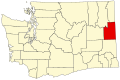 |
| สตีเวนส์เคาน์ตี้ | 065 | โคลวิลล์ | 1863 | วอลลา วอลลา เคาน์ตี | ไอแซค สตีเวนส์ (1818–1862) ผู้ว่าการคนแรกของดินแดนวอชิงตัน[ 36 ] | 49,668 | 2,478 ตาราง ไมล์( 6,418 ตาราง กิโลเมตร) |  |
| เทศมณฑลเธอร์สตัน | 067 | โอลิมเปีย | 1852 | ลูอิสเคาน์ตี้ | ซามูเอล เธอร์สตัน (1815–1851) ผู้แทนคนแรกของ ดินแดนโอเร กอน ในรัฐสภาสหรัฐฯ[ 37 ] | 304,261 | 722 ตาราง ไมล์( 1,870 ตาราง กิโลเมตร) |  |
| เทศมณฑล วาห์คิอาคุม | 069 | แคทลาเมต | 1854 | เคาน์ตีคาวลิทซ์ | วากายาคัม หัวหน้าเผ่าคาธลาเมต[ 38 ] | 4,873 | 264 ตาราง ไมล์( 684ตาราง กิโลเมตร) |  |
| วอลลา วอลลาเคาน์ตี | 071 | วอลลา วอลลา | 1854 | เทศมณฑลสกามาเนีย | เผ่าวอลลา วอลลาซึ่งเป็นชื่อในภาษาเนซ เพอร์เซ่ที่แปลว่าน้ำไหล[ 38 ] | 62,361 | 1,270 ตาราง ไมล์( 3,289 ตาราง กิโลเมตร) |  |
| วอทคอมเคาน์ตี้ | 073 | เบลลิงแฮม | 1854 | ไอส์แลนด์เคาน์ตี้ | Whatcom หัวหน้าเผ่า Nooksackและตั้งชื่อตาม คำในภาษา Nooksackที่แปลว่า "น้ำที่มีเสียงดัง" [ 39 ] | 236,392 | 2,107 ตาราง ไมล์( 5,457 ตาราง กิโลเมตร) | 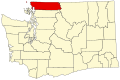 |
| เทศมณฑลวิทแมน | 075 | คอลแฟกซ์ | 1871 | สตีเวนส์เคาน์ตี้ | มาร์คัส วิทแมน (ค.ศ. 1802–1847) มิ ชชันนารีเมธอดิสต์[ 40 ] | 48,512 | 2,159 ตาราง ไมล์( 5,592 ตาราง กิโลเมตร) |  |
| เทศมณฑลยาคิมา | 077 | ยากิมา | 1865 | เขตเฟอร์กูสัน (ยุบไปแล้ว) | เผ่ายาคามะหมายถึง "น้ำที่ไหลเชี่ยว" หรือ "ท้องใหญ่" [ 41 ] | 259,185 | 4,296 ตาราง ไมล์( 11,127 ตาราง กิโลเมตร) |  |
ชื่อเขตปกครองเดิม
มีสี่เทศมณฑลที่เปลี่ยนชื่อระหว่างปี 1849 ถึง 1925
- เทศมณฑลเชฮาลิส ซึ่งเดิมตั้งชื่อตามชาวเชฮาลิสได้รับการเปลี่ยนชื่อเป็นเทศมณฑลเกรย์สฮาร์เบอร์ในปี พ.ศ. 2458 [ 42 ] [ 43 ]
- เทศมณฑล Sawamish ซึ่งเดิมตั้งชื่อตามชนเผ่าพื้นเมืองอเมริกันSahewamish ได้รับการเปลี่ยนชื่อเป็น เทศมณฑล Masonในปี พ.ศ. 2407 [ 44 ]
- เดิมที Slaughter County ตั้งชื่อตามร้อยโท William A. Slaughter ซึ่งเสียชีวิตระหว่างสงครามอินเดียนแดง ต่อมาได้เปลี่ยนชื่อเป็นKitsap Countyไม่นานหลังจากก่อตั้งในปี พ.ศ. 2490 [ 45 ]ข้อเสนอเริ่มต้นสำหรับเคาน์ตีนี้เรียกว่า Madison County หรือ Kitsap County [ 46 ]
- เดิมที Vancouver County ตั้งชื่อตามGeorge Vancouverแต่ต่อมาเปลี่ยนชื่อเป็นClarke Countyในปี พ.ศ. 2492 [ 47 ] [ 48 ]และแก้ไขเป็น Clark ในปี พ.ศ. 2468 [ 49 ]
อดีตเขตปกครอง
ในช่วงที่วอชิงตันยังเป็นดินแดนปกครองตนเอง วอชิงตันได้แยกตัวออกมาจากเคาน์ตีหนึ่งในรัฐโอเรกอน เคาน์ตีสามแห่งถูกยุบ และอีกสามแห่งแยกตัวออกเป็นดินแดนปกครองตนเอง
- เคาน์ตีแคลคามัส รัฐโอเรกอนก่อตั้งขึ้นในปี พ.ศ. 2387 และครอบคลุมพื้นที่ทางใต้และตะวันออกของแม่น้ำโคลัมเบีย จนกระทั่งมีการจัดตั้งดินแดนวอชิงตันขึ้นในปี พ.ศ. 2496 ซึ่งในเวลานั้นพื้นที่ดังกล่าวไม่ได้ถูกจัดตั้งเป็นเคาน์ตีอีกต่อไป[ 50 ]
- Spokane County ก่อตั้งขึ้นใน Washington Territory ในปี พ.ศ. 2491 จนกระทั่งรวมเข้ากับ Stevens County ในปี พ.ศ. 2407 และได้รับการก่อตั้งขึ้นใหม่ในปี พ.ศ. 2422 [ 51 ]
- เทศมณฑลมิสซูลาได้รับการจัดตั้งขึ้นในดินแดนวอชิงตันในปี พ.ศ. 2403 จนกระทั่งแยกตัวออกไปรวมกับดินแดนไอดาโฮในปี พ.ศ. 2406 [ 51 ]
- เทศมณฑลโชโชนเทศมณฑลไอดาโฮและเทศมณฑลเนซเพอร์ซก่อตั้งขึ้นในดินแดนวอชิงตันในปี พ.ศ. 2404 และเทศมณฑลบอยซีในปี พ.ศ. 2406 จนกระทั่งแยกตัวออกไปอยู่ในดินแดนไอดาโฮในเดือนมีนาคม พ.ศ. 2406 ทำให้เหลือพรมแดนปัจจุบันของวอชิงตัน[ 51 ]
- เทศมณฑลเฟอร์กูสัน ซึ่งตั้งชื่อตามเจมส์ แอล. เฟอร์กูสัน สมาชิกสภานิติบัญญัติแห่งรัฐวอชิงตัน ก่อตั้งขึ้นเมื่อวันที่ 23 มกราคม พ.ศ. 2406 โดยแยกมาจากเทศมณฑลวอลลา วอลลาและถูกยุบเมื่อวันที่ 18 มกราคม พ.ศ. 2408 โดยมีการจัดตั้ง เทศมณฑลยาคิมาขึ้นแทนที่[ 52 ] [ 53 ]
- เขตควิลฮุยต์ถูกแยกออกจากเขตเจฟเฟอร์สันและแคลลัมในปี พ.ศ. 2411 และกลับคืนสู่เขตเหล่านั้นอีกครั้งในอีกหนึ่งปีต่อมาก่อนที่จะมีการจัดตั้งเขต[ 54 ]
เขตปกครองที่เสนอ
มีการเสนอชื่อเขตปกครองหลายแห่งก่อนหรือระหว่างการก่อตั้งดินแดนวอชิงตัน และมีการเสนอชื่อเขตปกครอง 9 แห่งภายใน 16 ปีแรกของการก่อตั้งรัฐวอชิงตัน แต่ไม่มีเขตปกครองใดได้รับการจัดตั้งขึ้น
- ตัวแทนในการประชุม Cowlitz ในปี พ.ศ. 2394 ได้หารือเกี่ยวกับข้อเสนอในการจัดตั้งดินแดนโคลัมเบีย ซึ่งรวมถึงเคาน์ตีใหม่จำนวนหนึ่งในพื้นที่ซึ่งต่อมากลายเป็นวอชิงตัน การประชุมสภานิติบัญญัติดินแดนโอเรกอนครั้งถัดไปได้จัดตั้งเคาน์ตีขึ้นเพียงหนึ่งในนั้น คือ เคาน์ตีเธอร์สตัน (ซึ่งเดิมทีเสนอให้เป็นเคาน์ตีซิมมอนส์) [ 55 ] [ 56 ]
- เทศมณฑลบูคานันได้รับการเสนอในปี พ.ศ. 2499 ให้เป็นส่วนหนึ่งของเทศมณฑลคลาร์ก[ 57 ]
- เขตปกครองที่เสนอในช่วงแรกๆ ของการก่อตั้งรัฐวอชิงตัน ได้แก่ บิ๊กเบนด์ (ค.ศ. 1891), พาโลส (ค.ศ. 1891 และ ค.ศ. 1903), เชอร์แมน (ค.ศ. 1891), วอชิงตัน (ค.ศ. 1891), เวนาชี (ค.ศ. 1893), แมคคินลีย์ (ค.ศ. 1903), สเตปโท (ค.ศ. 1903) และคูลี (ค.ศ. 1905) [ 6 ]
- ตั้งแต่ทศวรรษ 1990 เป็นต้นมา มีข้อเสนอการแยกตัวของเคาน์ตี หลายแห่ง ในวอชิงตัน โดยส่วนใหญ่มาจากพื้นที่ชนบทในเคาน์ตีหลักทางตะวันตกของวอชิงตัน เคาน์ตี Cedar, Freedom และ Skykomish ได้ยื่นคำร้องขอแยกตัวออกจากเคาน์ตี King และ Snohomish ในปี 1995 และ 1996 โดยได้รับการสนับสนุนจากสภานิติบัญญัติของรัฐให้จัดทำประชามติ[ 4 ] [ 58 ] [ 59 ]
ดูเพิ่มเติม
ลิงก์ภายนอก
- สมาคมเทศมณฑลแห่งรัฐวอชิงตัน
- ข้อมูลเทศบาลของเคาน์ตีวอชิงตัน – ศูนย์วิจัยและบริการเทศบาลแห่งรัฐวอชิงตัน
- เจ้าหน้าที่ระดับเคาน์ตี – สมาคมเจ้าหน้าที่ระดับเคาน์ตีแห่งรัฐวอชิงตัน
- สมาคมเทศมณฑลแห่งชาติ – ค้นหาเทศมณฑล
อ่านเพิ่มเติม
- ผู้เขียน, Statf (2022). "ภาพรวมรัฐบาลเทศมณฑลวอชิงตัน" (PDF) . ce.naco.org . สมาคมเทศมณฑลแห่งชาติ (NACo) . สืบค้นเมื่อ3 มกราคม 2025 .