
Inagi
Inagi 稲城市 | |
|---|---|
 Clockwise from top left: Yomiuri Land Amusement Park, Aoi Shrine, Stone Buddha Statue in Mount Arigata, Anazawa-ten Shrine, Inagi Central Park, Inagi Bridge | |
 Flag  Seal | |
 Location of Inagi in Tokyo | |
  Inagi | |
| Coordinates: 35°38′16.6″N139°30′16.4″E/35.637944°N 139.504556°E | |
| Country | Japan |
| Region | Kantō |
| Prefecture | Tokyo |
| Area | |
• Total | 17.97 km2 (6.94 sq mi) |
| Population (April 2021) | |
• Total | 92,585 |
| • Density | 5,152/km2 (13,340/sq mi) |
| Time zone | UTC+9 (Japan Standard Time) |
| Symbols | |
| • Tree | Ginkgo biloba |
| • Flower | Pyrus pyrifolia |
| Phone number | 042-378-2111 |
| Address | 2111 Higashi-Naganuma, Inagi-shi, Tokyo 206-8601 |
| Website | Official website |
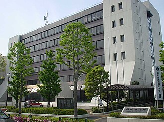
Inagi (稲城市, Inagi-shi) is a city located in the western portion of the Tokyo Metropolis, Japan. As of 1 April 2021, the city had an estimated population of 92,585 in 41,592 households, and a population density of 5200 persons per km2.[1] The total area of the city was 17.97 square kilometres (17,970,000 m2).
Geography
Inagi is located in the south-central portion of Tokyo Metropolis, approximately 25 kilometers from the center of Tokyo. The Tama River flows through the city, which is bordered by Kanagawa Prefecture to the south.
Surrounding municipalities
Climate
Inagi has a humid subtropical climate (Köppen Cfa) characterized by warm summers and cool winters with light to no snowfall. The average annual temperature in Inagi is 14.3 °C. The average annual rainfall is 1647 mm with September as the wettest month. The temperatures are highest on average in August, at around 25.6 °C, and lowest in January, at around 3.2 °C.[2]
Demographics
Per Japanese census data,[3] the population of Inagi has increased steadily since the 1950s.
| Year | Pop. | ±% |
|---|---|---|
| 1950 | 9,824 | — |
| 1960 | 11,012 | +12.1% |
| 1970 | 30,817 | +179.8% |
| 1980 | 48,154 | +56.3% |
| 1990 | 58,635 | +21.8% |
| 2000 | 69,235 | +18.1% |
| 2010 | 84,835 | +22.5% |
| 2020 | 93,151 | +9.8% |
History
พื้นที่อินางิมีผู้คนอาศัยอยู่มาตั้งแต่ยุคหินเก่าของญี่ปุ่นหรือกว่า 20,000 ปี โดยพิจารณาจากหัวลูกศรเครื่องมือหินและหินขนาดเล็กที่พบในหลายพื้นที่ภายในเขตเมือง มีหลักฐานการตั้งถิ่นฐานหลายแห่งในสมัยโจมอนแต่การตั้งถิ่นฐานได้หายไปในช่วงปลายสมัยโจมอนเนื่องจากการเปลี่ยนแปลงสภาพภูมิอากาศและการปะทุของภูเขาไฟฟูจิ พื้นที่นี้มีผู้คนอาศัยอยู่เบาบางในสมัยยาโยอิและความหนาแน่นของการตั้งถิ่นฐานเพิ่มขึ้นในสมัยโคฟุน มีการค้นพบซาก โบราณสถานสมัยนาราจำนวนมากรวมถึงซากเตาเผา กระเบื้อง มุงหลังคาในสมัยเฮอันพื้นที่นี้กลายเป็นส่วนหนึ่งของโชเอ็นที่ควบคุมโดยตระกูลโอยามาดะ และต่อมาโดยตระกูลอินาเบะ ซึ่งเป็นสาขาย่อยของพวกเขา จนถึงสมัยคามาคุระและเป็นพื้นที่ที่มีการแย่งชิงกันระหว่างตระกูลอาชิกางะและตระกูลอุเอสึกิในสมัยมูโรมาจิและ เซ็นโกกุ หลังจากเริ่มต้นสมัยเอโดะพื้นที่นี้อยู่ภายใต้การปกครองโดยตรงของรัฐบาลโชกุนโทกูงาวะ เทศบาลอินางิได้รับการก่อตั้งขึ้นเมื่อวันที่ 1 เมษายน พ.ศ. 2432 ในฐานะหมู่บ้านแห่งหนึ่งในเขตมินามิตามะจังหวัดคานากาวะ ในขณะนั้น โดยเกิดจากการรวมตัวของหมู่บ้านเล็กๆ 6 แห่งก่อนยุคเมจิตามการจัดตั้งระบบเทศบาลสมัยใหม่ เขตดังกล่าวถูกโอนไปอยู่ภายใต้การบริหารของมหานครโตเกียวเมื่อวันที่ 1 เมษายน พ.ศ. 2436
เมื่อวันที่ 1 เมษายน 1957 หมู่บ้านอินางิได้รับการยกฐานะเป็นเมือง และเมื่อวันที่ 1 พฤศจิกายน 1971 ได้รับการยกฐานะเป็นนคร
รัฐบาล
เมืองอินางิมี รูปแบบการปกครองแบบ นายกเทศมนตรี-สภาโดยมีนายกเทศมนตรีที่มาจากการเลือกตั้งโดยตรง และ สภาเมือง ที่มีสมาชิก 22 คน เมืองอินางิร่วมกับเมืองทามะส่งสมาชิกสภากรุงโตเกียว 2 คน ในการเลือกตั้งสภาผู้แทนราษฎรของญี่ปุ่นเมืองอินางิเป็นส่วนหนึ่งของเขตเลือกตั้งที่ 30 ของโตเกียว
การเลือกตั้ง
เศรษฐกิจ
อินากิเป็นเมืองที่ผู้คนส่วนใหญ่ทำงานอยู่ในใจกลางโตเกียว เนื่องจากมี การสร้างโครงการ บ้านจัดสรร ขนาดใหญ่ ในเมืองใหม่ ในช่วงปลายทศวรรษ 1950, 1960 และ 1970 นอกจากนี้ยังมีการทำการเกษตรอยู่บ้าง โดยเฉพาะลูกแพร์และองุ่น บริษัทผลิตกระดาษNippon Filconมีสำนักงานใหญ่ตั้งอยู่ในอินากิ
การศึกษา
ระดับอุดมศึกษา:
กระทรวงศึกษาธิการของรัฐบาลโตเกียวบริหารจัดการโรงเรียนมัธยมปลายหนึ่งแห่ง:
Previously Inagi High School existed.
Inagi has twelve public elementary schools and six public junior high schools operated by the Inagi City Board of Education.
Municipal junior high schools:[4]
- Inagi No. 1 (稲城第一中学校)
- Inagi No. 2 (稲城第二中学校)
- Inagi No. 3 (稲城第三中学校)
- Inagi No. 4 (稲城第四中学校)
- Inagi No. 5 (稲城第五中学校)
- Inagi No. 6 (稲城第六中学校)
Municipal elementary schools:[4]
- Hirao (平尾小学校)
- Inagi No. 1 (稲城第一小学校)
- Inagi No. 2 (稲城第二小学校)
- Inagi No. 3 (稲城第三小学校)
- Inagi No. 4 (稲城第四小学校)
- Inagi No. 6 (稲城第六小学校)
- Inagi No. 7 (稲城第七小学校)
- Koyodai (向陽台小学校)
- Minamiyama (南山小学校)
- Nagamine (長峰小学校)
- Shiroyama (城山小学校)
- Wakabadai (若葉台小学校)
There is one private junior-senior high school:
Transportation
Railway


Highway
 Chūō Expressway - Inagi IC
Local attractions
- Yomiuriland Amusement Park
Sports
- Tokyo Verdy, men's football team
- NTV Beleza, women's football team
Notable people from Inagi
- Kunio Okawara, anime mechanical designer
External links

- Inagi City Official Website(in Japanese)