
Seismic hazard
| Part of a series on |
| Earthquakes |
|---|
 |
|

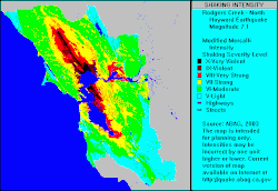
A seismic hazard is the probability that an earthquake will occur in a given geographic area, within a given window of time, and with ground motion intensity exceeding a given threshold.[1][2] With a hazard thus estimated, seismic risk can be assessed and included in such areas as building codes for standard buildings, designing larger buildings and infrastructure projects, land use planning and determining insurance rates.
The seismic hazard studies also may generate two standard measures of anticipated ground motion, both confusingly abbreviated MCE; the simpler probabilisticmaximum considered earthquake (or event[3]), used in standard building codes, and the more detailed and deterministicmaximum credible earthquake incorporated in the design of larger buildings and civil infrastructure like dams or bridges. It is important to be clear which MCE is being discussed.[4]
Determination
Calculations for determining seismic hazard were first formulated by C. Allin Cornell in 1968[5] and, depending on their level of importance and use, can be quite complex.[6] The regional geology and seismology setting is first examined for sources and patterns of earthquake occurrence, both in depth and at the surface from seismometer records; secondly, the impacts from these sources are assessed relative to local geologic rock and soil types, slope angle and groundwater conditions. Zones of similar potential earthquake shaking are thus determined and drawn on maps. The well known San Andreas Fault is illustrated as a long narrow elliptical zone of greater potential motion, like many areas along continental margins associated with the Pacific Ring of Fire. Zones of higher seismicity in the continental interior may be the site for intraplate earthquakes) and tend to be drawn as broad areas, based on historic records, like the 1812 New Madrid earthquake, since specific causative faults are generally not identified as earthquake sources.
Each zone is given properties associated with source potential: how many earthquakes per year, the maximum size of earthquakes (maximum magnitude), etc. Finally, the calculations require formulae that give the required hazard indicators for a given earthquake size and distance. For example, some districts prefer to use peak acceleration, others use peak velocity, and more sophisticated uses require response spectral ordinates.
The computer program then integrates over all the zones and produces probability curves for the key ground motion parameter. The final result gives a 'chance' of exceeding a given value over a specified amount of time. Standard building codes for homeowners might be concerned with a 1 in 500 years chance, while nuclear plants look at the 10,000 year time frame. A longer-term seismic history can be obtained through paleoseismology. The results may be in the form of a ground response spectrum for use in seismic analysis.
รูปแบบที่ซับซ้อนมากขึ้นในหัวข้อนี้ยังพิจารณาสภาพดินด้วย[ 7 ]มีแนวโน้มที่จะเกิดการสั่นสะเทือนของพื้นดินมากขึ้นในพื้นที่ชื้นแฉะเมื่อเทียบกับพื้นที่หินแข็ง การคำนวณอันตรายจากแผ่นดินไหวมาตรฐานจะถูกปรับเพิ่มขึ้นเมื่อตั้งสมมติฐาน เกี่ยวกับ แผ่นดินไหวลักษณะเฉพาะพื้นที่ที่มีการสั่นสะเทือนของพื้นดินสูงเนื่องจากสภาพดินมักจะเสี่ยงต่อการเกิดดินถล่มเนื่องจากปรากฏการณ์ดินเหลว ดินถล่มยังสามารถเกิดขึ้นได้เนื่องจากดินถล่ม ที่เกิดจากแผ่นดินไหว ในพื้นที่ลาดชัน การเกิดดินถล่มในพื้นที่ขนาดใหญ่ยังสามารถเกิดขึ้นได้บนเนินลาดที่ไม่สูงชันมากนัก ดังที่เห็นในเหตุการณ์แผ่นดินไหววันศุกร์ประเสริฐในเมืองแองเคอเรจ รัฐอะแลสกาเมื่อวันที่ 28 มีนาคม พ.ศ. 2507
แผ่นดินไหวที่คาดการณ์/น่าเชื่อถือได้สูงสุด
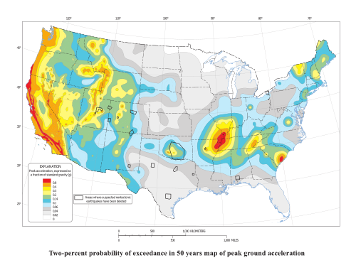
ในการวิเคราะห์ความเสี่ยงจากแผ่นดินไหวทั่วไปที่จัดทำขึ้นสำหรับประชาชน “แผ่นดินไหวที่คาดการณ์ได้สูงสุด” หรือ “เหตุการณ์แผ่นดินไหวที่คาดการณ์ได้สูงสุด” (MCE) สำหรับพื้นที่เฉพาะนั้น หมายถึงแผ่นดินไหวที่คาดว่าจะเกิดขึ้นหนึ่งครั้งในรอบประมาณ 2,500 ปี หรือกล่าวอีกนัยหนึ่งคือ มีโอกาส 2 เปอร์เซ็นต์ที่จะเกินกว่าระดับนี้ภายใน 50 ปี คำนี้ถูกนำมาใช้เฉพาะในข้อกำหนดด้านการก่อสร้างทั่วไป ซึ่งเป็นอาคารที่ผู้คนอาศัยอยู่เป็นประจำ ข้อกำหนดด้านการก่อสร้างในหลายพื้นที่กำหนดให้ต้องออกแบบอาคารที่ไม่จำเป็นเพื่อ “ป้องกันการพังทลาย” ในกรณีเกิด MCE เพื่อให้ตัวอาคารยังคงตั้งอยู่ได้ – ช่วยให้ผู้ที่อยู่ในอาคารสามารถหนีออกมาได้อย่างปลอดภัย – มากกว่าที่จะเน้นการคงสภาพโครงสร้างของอาคารอย่างสมบูรณ์
MCE ที่ละเอียดและเข้มงวดกว่ามากนั้นหมายถึง "แผ่นดินไหวที่น่าเชื่อถือสูงสุด" [ 8 ] [ 9 ]ซึ่งใช้ในการออกแบบตึกระฟ้าและโครงสร้างพื้นฐานทางวิศวกรรมโยธาขนาดใหญ่ เช่น เขื่อน ซึ่งความล้มเหลวของโครงสร้างอาจนำไปสู่ผลกระทบที่ร้ายแรงอื่นๆ MCE เหล่านี้อาจต้องกำหนดเหตุการณ์แผ่นดินไหวที่เฉพาะเจาะจงมากกว่าหนึ่งครั้ง ขึ้นอยู่กับความหลากหลายของโครงสร้างที่รวมอยู่[ 10 ]
แผนที่แสดงความเสี่ยงจากแผ่นดินไหว

แผนที่บางส่วนที่เผยแพร่โดยUSGSแสดงค่าความเร่งสูงสุดของพื้นดิน โดย มีโอกาสเกิน 10% ใน 50 ปี โดยวัดเป็นเมตรต่อวินาทีกำลังสองสำหรับบางส่วนของสหรัฐอเมริกา โครงการจัดทำแผนที่อันตรายจากแผ่นดินไหวแห่งชาติในปี 2551 ส่งผลให้แผนที่อันตรายจากแผ่นดินไหวแสดงค่าความเร่งสูงสุด (เป็นเปอร์เซ็นต์ของแรงโน้มถ่วง ) โดยมีโอกาสเกิน 2% ใน 50 ปีTemblorบริษัทที่ก่อตั้งขึ้นในปี 2557 ให้บริการจัดอันดับอันตรายจากแผ่นดินไหวสำหรับสหรัฐอเมริกาทั้งหมด บริการนี้ฟรีและไม่มีโฆษณาสำหรับประชาชนทั่วไป การจัดอันดับอันตราย "จัดทำขึ้นสำหรับความน่าจะเป็นที่จะประสบกับการสั่นสะเทือนอย่างรุนแรง (ค่าความเร่งสูงสุดของพื้นดิน 0.4g) ใน 30 ปี โดยอิงจากแบบจำลองอันตราย NSHMP ของ USGS ปี 2557" [ 11 ]
แผนที่แสดงอันตรายจากแผ่นดินไหวทั่วโลกยังแสดงระดับของการเคลื่อนที่ของพื้นดินบางอย่างที่มีโอกาสเกิน 10% (หรือมีโอกาสไม่เกิน 90%) ในช่วงเวลา 50 ปี (ซึ่งสอดคล้องกับช่วงเวลาการเกิดซ้ำ 475 ปี) [ 12 ]