
เฟลลัส
| เฟลโลส | |
|---|---|
| Phellos ( ภาษาตุรกี ) Φέλλος ( ภาษากรีกโบราณ ) ( ภาษากรีกโบราณ ) | |
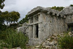 สุสานลิเซียที่เมืองเฟลลัส | |
 แผนที่แบบอินเทอร์แอ็กทีฟของเมืองเฟลโลส | |
| 36°14′05″N 29°37′56″E / 36.23472°N 29.63222°E / 36.23472; 29.63222 | |
| พิมพ์ | การตั้งถิ่นฐาน |
| ที่ตั้ง | ใกล้กับ เมือง ชูกูร์บาğใน ปัจจุบัน จังหวัดอันตัลยาประเทศตุรกี |
| ภูมิภาค | ไลเซีย |
| หมายเหตุเว็บไซต์ | |
| วันที่ขุดค้น | 1840 |
| นักโบราณคดี | ชาร์ลส์ เฟลโลว์ส |
| เงื่อนไข | พังทลาย |
| การเข้าถึงสาธารณะ | ใช่ |
เฟลลัส ( ภาษาตุรกี: Phellos , ภาษาลิเซีย: Wehnti ; ภาษากรีกโบราณ: Φέλλος ) เป็นที่ตั้งของ เมือง ลิเซียโบราณตั้งอยู่ในพื้นที่ภูเขาใกล้กับชูคูร์บาğในจังหวัดอันตัลยาประเทศตุรกี เมืองนี้ได้รับการกล่าวถึงโดยสตรโบนักภูมิศาสตร์และนักปรัชญากรีกในหนังสือภูมิศาสตร์ ของ เขา แอนติเฟลลัสทำหน้าที่เป็นท่าเรือของเมืองนี้
ในอดีตเคยมีความสับสนในหมู่นักวิชาการเกี่ยวกับตำแหน่งที่ตั้งที่แน่นอนของเมืองเฟลลัส ในปี ค.ศ. 1840 ชาร์ลส์ เฟลโลว์ส นักสำรวจและ นักโบราณคดี ชาวอังกฤษ ได้ใช้ จารึกภาษา กรีก ที่อ่านยากมาพิจารณาว่าเมืองนี้ตั้งอยู่ใกล้กับหมู่บ้านซาเรต
ประวัติศาสตร์
เฟลลัส ( ภาษากรีกโบราณ: Phellos : "พื้นที่หิน") [ 1 ]เป็น เมือง ลิเซีย โบราณ ซึ่งปรากฏในบันทึกครั้งแรกเมื่อนักประวัติศาสตร์และนักภูมิศาสตร์ชาวกรีกเฮกาเตอุส กล่าวถึง ในราว500 ปีก่อน คริสตกาล โดยระบุ ตำแหน่งผิดพลาดว่าอยู่ในแพมฟิเลีย [ 2 ] สคิแลกซ์แห่งคาริอันดาซึ่งเขียนในช่วงปลายศตวรรษที่ 6 หรือต้นศตวรรษที่ 5 ก่อนคริสตกาล ได้กล่าวถึงเฟลลัส[ 3 ]สุสานที่เฟลลัสเป็นหลักฐานที่เก่าแก่ที่สุดบางส่วนเกี่ยวกับการตั้งถิ่นฐานในภูมิภาคนี้โดยชาวลิเซีย[ 4 ]
เมืองนี้เป็นสมาชิกของสันนิบาตลิเซียในช่วงเวลาที่ควบคุมดินแดนในภูมิภาคและปราสาทที่บายินดีร์และลิมานี[ 2 ]ตามที่เฮคาเทอุสกล่าว ชื่อลิเซียของเมืองนี้คือเวฮินดา [ 3 ] การตั้งถิ่นฐานนี้มีความพิเศษตรงที่ปัจจุบันยังคงเป็นที่รู้จักในชื่อภาษากรีก[ 1 ]ชาวลิเซียใช้ชื่อของตนเองสำหรับเมืองนี้[ 5 ]การวิเคราะห์การกระจายและลักษณะของสุสานลิเซียโดยแยน ซาห์เล สรุปได้ว่าในช่วงยุคคลาสสิก เฟลลอส ลิมีราและปาทารา เป็นเมืองที่ มีความสำคัญรองลงมาจากซานโทส[ 6 ]ในช่วงศตวรรษที่ 5 สมาชิกของราชวงศ์ซานโทสอาศัยอยู่ที่นั่น ดังนั้นเมืองนี้จึงเคยมีบทบาททางการเมืองที่สำคัญ[ 7 ]อย่างไรก็ตาม การขยายตัวของเมืองไม่ได้เกิดขึ้น แม้ว่าจะมีการสร้างโรงละครขนาดเล็ก และอนุสาวรีย์คลาสสิกได้รับการอนุรักษ์ไว้อย่างดีโดยคนรุ่นต่อๆ มา[ 8 ]
เฟลลัสตั้งอยู่ภายในแผ่นดิน และแอนติเฟลลัสซึ่งเป็นเมืองชายฝั่งทางใต้ ทำหน้าที่เป็นท่าเรือ[ 9 ]เฟลลัส ต่างจากแอนติเฟลลัส ตรงที่ไม่ได้รับการกล่าวถึงในคู่มือการเดินเรือของชาวโรมันStadiasmus Maris Magni [ 10 ] เป็นเมืองสำคัญในช่วงศตวรรษที่ 5 ก่อนคริสต์ศักราช และยังคงเป็นศูนย์กลางสำคัญจนถึงศตวรรษถัดมา โดยมีheroön ที่โดดเด่น (ศาลเจ้าที่อุทิศให้กับวีรบุรุษ) [ 2 ]บทบาทของเมืองในฐานะศูนย์กลางราชวงศ์สิ้นสุดลงเมื่อเพริเคิลแห่งลิมีรา พิชิตเมืองนี้ได้ ในช่วงทศวรรษที่ 390 [ 11 ]ใน ช่วงยุค เฮลเลนิสติก แอนติเฟลลัสได้เข้ามาแทนที่เฟลลัส และขยายตัวกลายเป็นศูนย์กลางการค้าที่เจริญรุ่งเรือง ในขณะที่เฟลลัสลดความสำคัญลง[ 12 ]
เฟลลัสกลายเป็นศูนย์กลางของคริสตจักรในช่วงยุคไบแซนไทน์[ 2 ] [หมายเหตุ 1 ]
คำอธิบาย
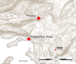
Phellus is located near the small settlement of Çukurbağ.[2] The site is reached by means of a footpath that leads through the undergrowth. The hilltop site is 550 metres (1,800 ft) long and 150 metres (490 ft) wide. Parts of the city's northern wall are visible; the corresponding wall on the south side is barely recognizable.[14]
The ruins mainly consist of the remains of the city walls surrounding an acropolis, with what were probably watchtowers adjoining them.[15] There are fully and partly exposed and rock tombs, including an example of one with a Greek inscription, and an epitaph written in Lycian. Towards the west end of the site is a free-standing tomb of house-type cut from the rock; the chamber has benches on three sides. Other ruins include house-tombs and other small tombs of various states of preservation, a semi-circular wall, and a rock-wall with a relief of a bull. There is a natural spring nearby.[16]
A well-preserved sarcophagus with reliefs on three sides is located close by the walls. One relief shows two birds and three figures, one of which is a reclining man holding a cup;. another depicts a warrior, but partly destroyed by a large hole broken into the tomb, and on the lid are a pair of griffins and two figures.[14] The Greek inscription on one sarcophagus can be read.[15] Beyond the main site are five other sarcophagi.[14]
Archaeology

In 1842, an expedition to Lycia, led by the English naval officer Thomas Abel Brimage Spratt, continued the work of the British naval officer Richard Hoskyn and his assistant, W.S. Harvey, in the restoration of archaeological sites discovered by the English explorer Charles Fellows.[17]
Spratt journeyed to the small farming village of Saaret north of Antiphellus,[18] accompanied by Panayotis, the same guide Fellows had used to discover the settlement.[19] He visited a site on the mountain of Felendağı, near Çukurbağ, and concluded that it was Phellus.[20] Wanting to charter and survey Phellus for himself, he consulted the works of Roman scholars to verify the location of the ruins; citing Livy's claim of a town near Phoenicus that acted as "the port of Phellus",[21] and Pliny the Elder's writings, which suggested that Phellus was directly north of Habessus, a pre-Hellenic name for Antiphellus.[22]
In an hour we reached a small plateau on the top of the ridge; crossing it, we came to the village at the foot of a hill, a spur of the mountain intervening between this little plain and the valley of Saaret The name of this place our guide said was Fellerdagh—the resemblance of which to Phellus, and the situation so near behind Antiphellus, gave us hopes that we had now discovered the true situation of that city.[23]
—Thomas Abel Brimage Spratt, Travels in Lycia, Milyas, and the Cibyratis, in company with the late Rev. E. T. Daniell (1847)
Spratt's findings were first challenged in 1892, when the German-Austrian archaeologistOtto Benndorf determined that Phellus was located on the coast across the bay from Antiphellus.[24]
Phellus has been intensively surveyed, but is one of a number of Lycian sites where a lack of archaeological evidence prevents it from being classified as a town comparable in size to Xanthus.[25] Subsequent building activity has meant that few architectural details can now be identified, and the social and economic structure of the city has not been determined.[7]
Notes
- ↑Phellus remains a titular see of the Roman Catholic Church.[13]
แหล่งที่มา
แหล่งข้อมูลปฐมภูมิ
- ลิเวียส ปาตาวินัส, ไททัส (1836) ลิวี: เล่ม XXXI– XXXVIII นิวยอร์ก: ฮาร์เปอร์และบราเธอร์สโอซีแอลซี613192896 .
- พลินิอุส เซคุนดัส, ไกอุส (1848). ประวัติศาสตร์ธรรมชาติของพลินี . แมสซาชูเซตส์: สำนักพิมพ์มหาวิทยาลัยฮาร์วาร์ด. OCLC 578716495 .
แหล่งข้อมูลทุติยภูมิ
- Akşit, อิลฮาน (2006) ไคลน์, สจวร์ต (เอ็ด.) Lycia: ดินแดนแห่งแสงสว่าง อิสตันบูล: Aksit Kultur Turizm Sanat Ajans Lt. ISBN 975-7039-11-X.
- เบย์บูร์ตลูโอกลู, เซฟเดต (2004) ลิเซีย . อันตัลยา: สถาบันวิจัย Suna & İnan Kıraçเกี่ยวกับอารยธรรมเมดิเตอร์เรเนียนไอเอสบีเอ็น 978-97570-7-820-3.
- บีน, จอร์จ อีวาร์ต (1978). ตุรกีลิเซีย: คู่มือทางโบราณคดี . ลอนดอน: เบนน์. ISBN 978-05100-3-205-0.
- คีน, แอนโทนี จี. (2018). ราชวงศ์ลิเซีย: ประวัติศาสตร์การเมืองของชาวลิเซียและความสัมพันธ์กับอำนาจต่างชาติ ประมาณ ค.ศ. 545–362 ก่อนคริสต์ศักราชไลเดน: สำนักพิมพ์บริลล์ ISBN 978-90043-5-152-3.
- Kolb, Frank (2019). "จากภูเขาถึงที่ราบชายฝั่ง: ที่ตั้งของชุมชนและขั้นตอนการพัฒนาเมืองในลิเซียโบราณ" ใน de Ligt, Luuk; Bintliff, John (บรรณาธิการ). ระบบเมืองระดับภูมิภาคในโลกโรมัน 150 ปีก่อนคริสต์ศักราช – 250 ปีคริสต์ศักราชไลเดน: สำนักพิมพ์ Brill ISBN 978-90-04-41433-4.
- Spratt, Thomas (1847a). Travels in Lycia, Milyas, and the Cibyratis, in company with the late Rev. E. T. Daniell. Vol. 1. London: J. Van Voorst. OCLC 582161294.
- Spratt, Thomas (1847b). Travels in Lycia, Milyas, and the Cibyratis, in company with the late Rev. E. T. Daniell. Vol. 2. London: J. Van Voorst. OCLC 582161294.
- Zimmermann, Martin (1992). Untersuchungen zur historischen Landeskunde Zentrallykiens[Investigations into the Historical Geography of Central Lycia] (in German). Bonn, Germany: Habelt. pp. 61–67. ISBN 978-37749-2-553-3.
- Zimmermann, Martin (2002). "Phellus". In Cancik, Hubert; Schneider, Helmuth (eds.). Brill's New Pauly: Encyclopaedia of the Ancient World. Vol. 10. Leiden: Brill Publishers.
Further reading
- Hülden, Oliver; Zimmermann, Martin, eds. (2025). Phellos. Geschichte und Archäologie einer zentrallykischen Stadtanlage und ihrer Nekropolen[Phellos. History and archaeology of a central Lycian city and its necropolises]. Gladbeck: PeWe. ISBN 978-3-935012-71-3..
- Schuler, Christof (2005). "Griechische Epigraphik in Lykien: Eine Zwischenbilanz"[Greek Epigraphy in Lycia: an interim assessment](PDF). Tituli Asiae Minoris (in German). 25 (supplementary volume). Austrian Academy of Sciences.
- Troxell, Hyla A. (1982). "The Coinage of the Lycian League". Numismatic Notes and Monographs (162): ii–255. JSTOR 43607364.
- Zimmermann, M. (2005). "Eine Stadt und ihr kulturelles Erbe. Vorbericht über Feldforschungen im zentrallykischen Phellos 2002–2004". Istanbuler Mitteilungen (in German) (55): 215–270.
- Zimmermann, M. (2006). "Phellos in Zentrallykien und die Grundmuster lykischer Siedlungsgeschichte". In Dörtlük, K. (ed.). The Third International Symposium on Lycia, 7–10 November 2005 (in German). Vol. 2. Antalya. pp. 907–916.
{{cite book}}: CS1 maint: location missing publisher (link)
External links

- Search results for Phellus from the Perseus Digital Library