
ทางหลวงรัฐเวอร์จิเนียหมายเลข 35
 ทางหลวงรัฐหมายเลข 35 | ||||
|---|---|---|---|---|
 | ||||
| ข้อมูลเส้นทาง | ||||
| ดูแลรักษาโดยVDOT | ||||
| ความยาว | 48.71 ไมล์[ 1 ] (78.39 กม.) | |||
| มีอยู่ | ตั้งแต่ปี 1923 จนถึงปัจจุบัน | |||
| จุดเชื่อมต่อหลัก | ||||
| ปลายด้านใต้ |  ทางหลวง NC 35ใกล้เมืองบอยกินส์ ทางหลวง NC 35ใกล้เมืองบอยกินส์ | |||
| สี่แยกสำคัญ |
| |||
| ฝั่งเหนือ |   ทางหลวงหมายเลข SR 605 / SR 622ในเมืองเทมเพิลตัน ทางหลวงหมายเลข SR 605 / SR 622ในเมืองเทมเพิลตัน | |||
| ที่ตั้ง | ||||
| ประเทศ | สหรัฐอเมริกา | |||
| สถานะ | เวอร์จิเนีย | |||
| เขตปกครอง | เซาแธมป์ตันซัสเซ็กซ์เจ้าชายจอร์จ | |||
| ระบบทางหลวง | ||||
| ||||


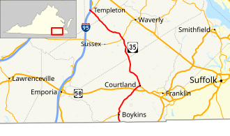
ทางหลวงรัฐหมายเลข 35 ( SR 35 ) เป็นทางหลวงสาย หลักของรัฐ เวอร์จิเนียประเทศสหรัฐอเมริกาทางหลวงสายนี้มีความยาว 48.71 ไมล์ (78.39 กิโลเมตร) เริ่มต้นจาก ชายแดนรัฐนอร์ ทแคโรไลนาใกล้เมืองบอยกินส์ซึ่งทางหลวงจะต่อเนื่องเป็นทางหลวงรัฐนอร์ทแคโรไลนาหมายเลข 35 (NC 35) ไปทางเหนือจนถึงทางหลวงรัฐหมายเลข 605 และทางหลวงรัฐหมายเลข 622 ในเมืองเทมเพิลตัน SR 35 เป็นทางหลวงสายหลักที่วิ่งจากเหนือจรดใต้ของเทศมณฑลเซาแธมป์ตันนอกจากนี้ ทางหลวงสายนี้ยังเชื่อมต่อทางหลวงสหรัฐหมายเลข 58 (US 58) ในเมืองคอร์ตแลนด์กับทางหลวงระหว่างรัฐหมายเลข 95 (I-95) และทางหลวงสหรัฐหมายเลข 301ที่เมืองเทมเพิลตัน ทางใต้ของเมืองปีเตอร์สเบิร์ก
คำอธิบายเส้นทาง

SR 35 begins at the North Carolina state line south of Boykins. The highway continues south as NC 35, which crosses the Meherrin River a short distance to the south. SR 35 heads north as Meherrin Road, which parallels the North Carolina and Virginia Railroad to the town of Boykins. The state highway follows Main Street through town and meets the eastern end of SR 186 (Beaton Avenue). SR 35 intersects CSX's Portsmouth Subdivision and continues northeast as Meherrin Road. Next to Southampton High School, the state highway meets US 58 (Southampton Parkway) at a diamond interchange. SR 35 runs concurrently with US 58 Business northeast on a through truss bridge over the Nottoway River into the town of Courtland. In the center of the county seat, US 58 Business turns south onto Main Street and SR 35 heads north and meets Norfolk Southern Railway's Franklin District at grade.[1][2]
SR 35 heads northwest from Courtland as Plank Road. The state highway crosses over then parallels the Assamoosick Swamp north into Sussex County. Within that county, SR 35 is named Jerusalem Plank Road (see Battle of Jerusalem Plank Road) and intersects SR 40 (Sussex Drive) in the hamlet of Homeville. The state highway continues into Prince George County as Courtland Road to the village of Templeton. SR 35 meets US 301 (Crater Road) just east of I-95; the intersection also serves as the southern terminus of SR 156 (Prince George Drive) and receives the exit ramp from northbound I-95. SR 35 and US 301 head west across I-95 and meet the other three ramps of the partial cloverleaf interchange with the Interstate. US 301 turns south onto Crater Road while the state highway continues to its terminus at the intersection of SR 605 (Spain Drive) and SR 622 (Providence Road).[1][2]
Major intersections
| County | Location | mi[1] | km | Destinations | Notes |
|---|---|---|---|---|---|
| Southampton | | 0.00 | 0.00 |  NC 35 south – Conway NC 35 south – Conway | North Carolina state line; southern terminus |
| Boykins | 2.64 | 4.25 |   SR 186 west (Beaton Avenue) – Branchville SR 186 west (Beaton Avenue) – Branchville | Eastern terminus of SR 186 | |
| | 8.76 | 14.10 |  SR 673 (Grays Shop Road) – Newsoms SR 673 (Grays Shop Road) – Newsoms | Former SR 194 south | |
| | 13.21 | 21.26 |  ทางหลวง หมายเลข 58 ของสหรัฐฯ – เอมโพเรีย , แฟรงคลิน ทางหลวง หมายเลข 58 ของสหรัฐฯ – เอมโพเรีย , แฟรงคลิน | ปลายด้านใต้ของทางหลวงหมายเลข 58 ของสหรัฐฯ เส้นทางเดินรถร่วม; จุดเชื่อมต่อ | |
| คอร์ทแลนด์ | 15.38 | 24.75 |   ทางหลวงหมายเลข 58 ของสหรัฐฯฝั่งตะวันออก (ถนนเมน) – แฟรงคลิน , เวอร์จิเนีย บีช , สะพานและอุโมงค์เชซาพีคเบย์ ทางหลวงหมายเลข 58 ของสหรัฐฯฝั่งตะวันออก (ถนนเมน) – แฟรงคลิน , เวอร์จิเนีย บีช , สะพานและอุโมงค์เชซาพีคเบย์ | ปลายด้านเหนือของถนน US 58 Bus. | |
| | 16.07 | 25.86 |  SR 616 (ถนนไอวอร์) – ไอวอร์ SR 616 (ถนนไอวอร์) – ไอวอร์ | ทางหลวงหมายเลข 312เดิมทางเหนือ | |
| ซัสเซ็กซ์ | โฮมวิลล์ | 33.67 | 54.19 |  SR 40 (Sussex Drive) – Stony Creek , Waverly SR 40 (Sussex Drive) – Stony Creek , Waverly | |
| ลูกแกะ | 43.94 | 70.71 |  SR 626 (ถนนคอร์ทเฮาส์) – ซัสเซ็กซ์ , เยล , ศูนย์ราชทัณฑ์เซาแธมป์ตัน SR 626 (ถนนคอร์ทเฮาส์) – ซัสเซ็กซ์ , เยล , ศูนย์ราชทัณฑ์เซาแธมป์ตัน | ทางหลวงหมายเลข 351เดิมทางใต้ | |
| เจ้าชายจอร์จ | เทมเพิลตัน | 47.99 | 77.23 |     จากทางหลวงหมายเลข 301มุ่งหน้าไปทางเหนือ (ถนนพรินซ์จอร์จ) ไปยังทางหลวงหมายเลข 156 จากทางหลวงหมายเลข 301มุ่งหน้าไปทางเหนือ (ถนนพรินซ์จอร์จ) ไปยังทางหลวงหมายเลข 156 | จุดสิ้นสุดทางใต้ของเส้นทางร่วมทางหลวงหมายเลข 301 ของสหรัฐอเมริกา |
 ทางหลวง หมายเลข I-95 – เอมโพเรีย , ปีเตอร์สเบิร์ก ทางหลวง หมายเลข I-95 – เอมโพเรีย , ปีเตอร์สเบิร์ก | ทางออกที่ 41 (I-95) | ||||
| 48.26 | 77.67 | ทางหลวงหมายเลข 301ใต้ (ถนนเซาท์เครเตอร์) | จุดสิ้นสุดทางเหนือของเส้นทางร่วมทางหลวงหมายเลข 301 ของสหรัฐอเมริกา | ||
| | 48.71 | 78.39 | SR 605 (ถนนสเปน) / SR 622 (ถนนโพรวิเดนซ์) | จุดสิ้นสุดทางเหนือ | |
1.000 ไมล์ = 1.609 กม.; 1.000 กม. = 0.621 ไมล์
| |||||
ลิงก์ภายนอก

- โครงการทางหลวงเวอร์จิเนีย: VA 35