
Yorkshire Water Way
| Yorkshire Water Way | |
|---|---|
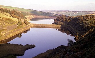 Bilberry and Digley Reservoirs. The dam wall in the middle is used by as a path by the Yorkshire Water Way | |
| Length | 104 miles (167 km) |
| Location | Yorkshire |
| Established | 2006 |
| Trailheads | Kettlewell, North Yorkshire54°08′48″N2°02′57″W / 54.1466°N 2.0491°W / 54.1466; -2.0491 (Yorkshire Water Way Walk, Kettlewell)Langsett Reservoir, South Yorkshire53°29′52″N1°40′44″W / 53.4978°N 1.6789°W / 53.4978; -1.6789 (Yorkshire Water Way Walk, Langsett Reservoir) |
| Use | Hiking |
| Maintained by | Yorkshire Water (partial) |
The Yorkshire Water Way is a 104-mile (167 km) path that runs from Kettlewell in North Yorkshire to Langsett in South Yorkshire. It was devised by Mark Reid in conjunction with Yorkshire Water (YW) and it passes by more than 20 reservoirs which are operated by Yorkshire Water.
Background
Yorkshire Water is the largest land owner in the Yorkshire and the Humber region, with over 72,000 acres (29,000 ha) and over 100 reservoirs in its portfolio.[1] The Yorkshire Water Way was devised in conjunction with Mark Reid, an established writer and authority on long-distance paths. In 2006, a book was launched to cover the first section between Kettlewell in North Yorkshire and Ilkley in West Yorkshire, with a book covering the southern section following two years later.[2] Yorkshire Water maintain most of the route, though some of the path is on existing routes such as the Pennine Way.[3]
The route is divided into the two stages: Kettlewell to Ilkley (41 miles (66 km)) and Ilkley to Langsett Reservoir (63 miles (101 km)). However, the books guide walkers to be able to complete the walk in stages, or the entire walk takes about seven days to complete.[4]
Route
เส้นทางเริ่มต้นที่หมู่บ้าน Kettlewell ใน Upper Wharfedale และมุ่งหน้าไปทางตะวันออกข้ามGreat Whernsideไปยังอ่างเก็บน้ำใน พื้นที่ Upper Nidderdale (Angram, Scar House และ Gouthwaite) จากนั้นมุ่งหน้าไปทางใต้ผ่านPateley Bridgeและเข้าสู่Washburn Valleyผ่านอ่างเก็บน้ำ Thruscross, Fewston และ Swinsty หลังจากนั้นจะผ่าน Denton Moor และเข้าสู่ West Yorkshire ผ่านสะพานคนเดินข้ามแม่น้ำ Wharfeไปยัง Ilkley [ 5 ]ซึ่งเป็นจุดสิ้นสุดของหนังสือเล่มแรก[ 6 ]
เส้นทางเดินป่าเริ่มต้นทางใต้ของเมือง Ilkley โดยข้ามทุ่ง Ilkley Moorผ่านอ่างเก็บน้ำ Weecher และเข้าสู่หุบเขา Aire ผ่านShipley , Bingley , Harden , Cullingworth , Cross RoadsและHaworthก่อนที่จะผ่านอ่างเก็บน้ำ Lower Laitheและมุ่งหน้าไปทางทิศตะวันตกข้ามทุ่ง Haworth Moor และลงสู่Calderdaleผ่านอ่างเก็บน้ำสามแห่งที่ Walshaw Dean หลังจากนั้น เส้นทางจะมุ่งหน้าไปทางใต้ผ่านHebden Bridgeแล้วผ่านอ่างเก็บน้ำ Withens Clough, Baitings, Dean Head และ Cupwith หลังจากMarsdenเส้นทางจะผ่าน อ่างเก็บน้ำ Butterley , Blakeley, Wessenden และ Wessenden Head ก่อนที่จะข้ามถนน A635 และเดินผ่านระหว่างอ่างเก็บน้ำ Bilberry และ Digley ที่ Holme เส้นทางจะผ่าน Brownhills และอ่างเก็บน้ำ Ramsden ก่อนที่จะมุ่งหน้าเข้าสู่ South Yorkshire ในทิศตะวันตกเฉียงใต้ ผ่านอ่างเก็บน้ำ Harden และ Winscar [ 7 ]ที่สะพานดันฟอร์ดเส้นทางจะมุ่งหน้าไปทางทิศตะวันออกแล้วไปทางทิศใต้เพื่อสิ้นสุดที่อ่างเก็บน้ำแลงเซตต์[ 8 ] [ 9 ]
อ่างเก็บน้ำ
รายชื่ออ่างเก็บน้ำเหล่านี้เรียงจากเหนือจรดใต้ (ตามทิศทางที่ควรใช้เส้นทาง) ซึ่งเส้นทางนี้จะตัดผ่านอ่างเก็บน้ำต่างๆ
- อ่างเก็บน้ำแองแกรม
- อ่างเก็บน้ำสการ์เฮาส์ ‡
- อ่างเก็บน้ำกูทเวท ‡
- อ่างเก็บน้ำทรัสครอส ‡
- อ่างเก็บน้ำฟิวสตัน ‡
- อ่างเก็บน้ำสวินสตี ‡
- อ่างเก็บน้ำวีเชอร์‡
- อ่างเก็บน้ำล่างไลธ์
- อ่างเก็บน้ำวอลชอว์ ดีน (ตอนบน ตอนกลาง‡ และตอนล่าง‡)
- อ่างเก็บน้ำกอร์เพิลล่าง
- อ่างเก็บน้ำวิเธนส์ คลัฟ‡
- อ่างเก็บน้ำสำหรับล่อเหยื่อ ‡
- อ่างเก็บน้ำบูธวูด
- อ่างเก็บน้ำดีนเฮด‡
- ถ้วยพร้อมช่องเก็บน้ำ‡
- อ่างเก็บน้ำบัตเตอร์ลีย์ ‡
- อ่างเก็บน้ำเบลคเลย์‡
- อ่างเก็บน้ำเวสเซนเดน ‡
- อ่างเก็บน้ำเวสเซนเดนเฮด ‡
- อ่างเก็บน้ำบิลเบอร์รี่ ‡
- อ่างเก็บน้ำดิกลีย์
- อ่างเก็บน้ำบราวน์ฮิลล์
- อ่างเก็บน้ำแรมส์เดน‡
- อ่างเก็บน้ำไรดิงวูด
- อ่างเก็บน้ำแข็ง‡
- อ่างเก็บน้ำวินสการ์ ‡
- อ่างเก็บน้ำอัปเปอร์วินด์เลเดน
- อ่างเก็บน้ำวินด์เลเดนตอนล่าง
- อ่างเก็บน้ำแลงเซตต์ ‡
- ‡เส้นทางเดินเลียบขอบอ่างเก็บน้ำหรือบริเวณหัวเขื่อน
เส้นทางเชื่อมต่อ
ในหุบเขาแอร์ เส้นทางจะเชื่อมต่อกับส่วนเชื่อมต่อแอร์/แคลเดอร์ของเพนไนน์บริดเดิลเว ย์ และเชื่อมต่อกับเพนไนน์บริดเดิลเวย์หลักใกล้กับเฮบเดนบริดจ์และเพนไนน์เวย์ในสถานที่เดียวกัน[ 10 ]