
ทางหลวงแห่งชาติจีนหมายเลข 219
 | ||||
|---|---|---|---|---|
| 219年道 | ||||
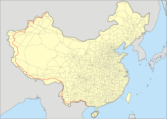 แผนการขยาย G219 | ||||
| ข้อมูลเส้นทาง | ||||
| ความยาว | 10,000 กิโลเมตร (6,200 ไมล์) ทางหลวงมีความยาว 2,342 กิโลเมตร (1,455 ไมล์) จนถึงปี 2013 ส่วนความยาวที่เสนอไว้คือมากกว่า 10,000 กิโลเมตร (6,214 ไมล์) ตามแผนงานของรัฐบาลปี 2013–2030 | |||
| มีอยู่ | ปี 1955–ปัจจุบัน | |||
| จุดเชื่อมต่อหลัก | ||||
| ปลายด้านตะวันตกเฉียงเหนือ | เขตการปกครองกลุ่มชาติพันธุ์ Kom-Kanas มองโกเลีย | |||
| ปลายด้านตะวันออกเฉียงใต้ | ตงซิง | |||
| ที่ตั้ง | ||||
| ประเทศ | จีน | |||
| ระบบทางหลวง | ||||
| ||||


ทางหลวงแห่งชาติจีนหมายเลข 219 ( G219; ภาษาจีน : Guódào 219 ) เป็นทางหลวงที่วิ่งเลียบชายแดนด้านตะวันตกและด้านใต้ของสาธารณรัฐประชาชนจีน ทั้งหมด จากเมืองคอมคานาสในซินเจียงไปยังเมืองตงซิงในกวางซี มีความยาว กว่า10,000 กิโลเมตร (6,214 ไมล์)เป็นส่วนหนึ่งของแผนเครือข่ายทางหลวงแห่งชาติจีน (2013–2030)และเมื่อสร้างเสร็จสมบูรณ์จะเป็นทางหลวงแห่งชาติ ที่ ยาว ที่สุด
ก่อนปี 2013 ทางหลวง G219 วิ่งเฉพาะจากเย่เฉิง (คาร์กิลิก)ในซินเจียงไปยังลัทเซในทิเบตเป็นระยะทาง2,342 กิโลเมตร (1,455 ไมล์)ส่วนนี้สร้างเสร็จในเดือนกันยายนปี 1957 อินเดียกำลังมีข้อพิพาทเรื่องดินแดนกับจีนเกี่ยวกับอักไซชินซึ่งทางหลวงส่วนนี้ตัดผ่านเป็นระยะทาง180 กิโลเมตร (112 ไมล์)หลังสงครามปี 1962จีนได้ควบคุมถนนสายนี้ไว้
เป็นครั้งแรกนับตั้งแต่ทศวรรษ 1960 ระหว่างปี 2010-2012 จีนได้ใช้งบประมาณ 3 พันล้านหยวน (476 ล้านดอลลาร์สหรัฐ) ในการปรับปรุงผิวถนนในเขตซินเจียง ซึ่งมีความยาวกว่า650 กิโลเมตร (404 ไมล์) แผนพัฒนาห้าปีฉบับที่ 13 (2016-2020) และฉบับที่ 14 (2021-2025) ของจีนต่างก็รวมถึงการพัฒนาถนนสายนี้และการเชื่อมต่อกับถนนสายอื่นๆ ด้วย
G219 ดั้งเดิม
การก่อสร้างถนนซินเจียง-ทิเบตซึ่งเป็นถนนลูกรังเริ่มขึ้นในปี พ.ศ. 2494 [ 1 ]ถนนสายนี้ยังเป็นที่รู้จักในชื่อ 'ถนนเย่ฉาง-การ์ต็อก' 'ถนนอักไซชิน' [ 2 ]และ 'ถนนลอยฟ้า' [ 3 ]เนื่องจากเป็นถนนสายตรงเพียงสายเดียวระหว่างซินเจียงและทิเบต จึงมีความสำคัญทางยุทธศาสตร์ต่อจีน
อักษะ ชิน

Through the 1950s, China constructed the road through its western frontier in Xinjiang and Tibet, from Hotan to Rutog.[4] It was completed in September 1957.[5][6]
About 180 km (112 mi) passes through Aksai Chin,[7] easily accessible to the Chinese, but more difficult for the Indians on the other side of the Karakoram to reach.[8] India did not learn of the road until 1957. Both sides lay claim to the area.[4]
The road enters disputed territory east of Sarigh Jilgnang after which it runs through territory India recognizes as its own. India claimed the road to be in contravention to the Sino-Indian Agreement 1954.[9] China repaved the road in the following years, which resulted in heightened tension.[4] A goal of the 1962 war was the defence of the road.[10][3] China retained control of the road,[11] taking even more territory further west before withdrawing. There is a Chinese war memorial on the G219 at Kangxiwar.[12]
Dispute over the territory persists to the present time.[4] A number of lateral roads, including to military infrastructure, have been constructed.[12]
Extension
Repaving of the existing road began in late 2010.[13] By July 2012 and with an expenditure of CN¥3 Billion ($476 million), the Xinjiang section spanning just over 650 km (404 mi) was completed. This was the first repaving since the 1960s, according to a Chinese road administration official. The 13th five-year plan (2016–2020) facilitated further upgrades to the road.[14] In 2013, the road was upgraded to asphalt.[7] A number of provincial roads have been and are being developed to exit off the G219: the G564 and the G365,[15] as well as the S205, S206 and S207.[16] China's 14th five-year plan for 2021–2025 envisions further improves connectivity of the G219.[17]
Route description
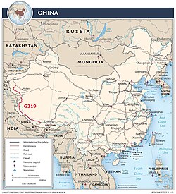
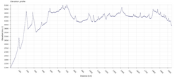
As one of the highest motorable roads in the world, the breathtaking scenery of Rutog County also ranks as some of the most inhospitable terrain on the planet. Domar township—a town of concrete blocks and nomad tents—is one of the bleakest and most remote outposts of the People's Liberation Army at the edge of the Aksai Chin. Near the town of Mazar many trekkers turn off for both the Karakorum range and K2 base camp. Approaching the Xinjiang border, past the final Tibetan settlement of Tserang Daban is a dangerous 5,050-meter-high pass. Tibetan nomads in the area herd both yaks and two-humped camels. Descending through the western Kunlun Shan, the road crosses additional passes of 4,000 and 3,000 meters, and the final pass offers brilliant views of the Taklamakan Desert far below before descending into the Karakax River basin.
The Chinese government is making efforts to promote tourism along G219.[18][19] There are a number of military check posts along the road.[20]
Route and distance

| Province | Prefecture | County | Township/Village/Landmark | Coord | km (mi) |
|---|---|---|---|---|---|
| Xinjiang | Kashgar | Kargilik (Yecheng) | Boxireke-xiang (zh) | 37°52′34″N77°27′58″E / 37.876°N 77.466°E / 37.876; 77.466 (Boxireke-xiang) | 0 |
| Kokyar | 37°23′38″N77°10′59″E / 37.394°N 77.183°E / 37.394; 77.183 (Kokyar) | 65 km (40 mi) | |||
| Pusa | 37°19′01″N77°08′42″E / 37.317°N 77.145°E / 37.317; 77.145 (Pusa) | 10 km (6 mi) | |||
| Akemei | 37°06′40″N77°00′36″E / 37.111°N 77.010°E / 37.111; 77.010 (Akemei) | 28 km (17 mi) | |||
| K104 military rest point | 37°05′31″N76°57′58″E / 37.092°N 76.966°E / 37.092; 76.966 (K104 military rest point) | 6 km (4 mi) | |||
| Akazi | 37°04′23″N76°52′44″E / 37.073°N 76.879°E / 37.073; 76.879 (Akazi) | 20 km (12 mi) | |||
| Kudi | 36°50′13″N76°58′52″E / 36.837°N 76.981°E / 36.837; 76.981 (Kudi) | 33 km (21 mi) | |||
| Mazar Pass | 36°34′44″N77°00′11″E / 36.579°N 77.003°E / 36.579; 77.003 (Mazar Pass) | 58 km (36 mi) | |||
| Kirgizjangal Pass | 36°24′14″N77°29′13″E / 36.404°N 77.487°E / 36.404; 77.487 (Kirgizjangal Pass) | 88 km (55 mi) | |||
| Hotan | Pishan | Xaidulla | 36°21′07″N78°01′37″E / 36.352°N 78.027°E / 36.352; 78.027 (Xaidulla) | 55 km (34 mi) | |
| Hotan | Dahongliutan | 35°58′55″N79°11′17″E / 35.982°N 79.188°E / 35.982; 79.188 (Dahongliutan) | 122 km (76 mi) | ||
| Xinjiang | Entering disputed area | 35°55′37″N79°16′08″E / 35.927°N 79.269°E / 35.927; 79.269 (Entering disputed area) | 10 km (6 mi) | ||
| Tianshuihai | 35°17′49″N79°33′40″E / 35.297°N 79.561°E / 35.297; 79.561 (Tianshuihai) | 102 km (63 mi) | |||
| Leaving disputed area | 34°47′06″N80°06′04″E / 34.785°N 80.101°E / 34.785; 80.101 (Leaving disputed area) | 85 km (53 mi) | |||
| Border between Xinjiang Uyghur AR and Tibet AR | |||||
| Tibet | Ngari | Rutog | Risong | 33°22′59″N79°43′44″E / 33.383°N 79.729°E / 33.383; 79.729 (Risong Township) | 265 km (165 mi) |
| Gar | Sengge Zangbo bridge | 32°30′00″N80°05′31″E / 32.500°N 80.092°E / 32.500; 80.092 (Sengge Zangbo bridge) | 125 km (78 mi) | ||
| Shigatse | Zhongba | Labrang | 29°46′05″N84°01′55″E / 29.768°N 84.032°E / 29.768; 84.032 (Labrang) | 580 km (360 mi) | |
| Saga | Gya'gya | 29°19′52″N85°13′48″E / 29.331°N 85.230°E / 29.331; 85.230 (Gya'gya) | 162 km (101 mi) | ||
| Ngamring | Gegang | 29°16′23″N87°10′55″E / 29.273°N 87.182°E / 29.273; 87.182 (Gegang) | 241 km (150 mi) | ||
| Lhatse | Chawu-xiang (zh) | 29°06′32″N87°34′55″E / 29.109°N 87.582°E / 29.109; 87.582 (Chawu-xiang) | 52 km (32 mi) | ||
| Total | 2,107 km (1,309 mi) | ||||
Mountain Passes Rhyme
The western portion of the highway has numerous notable mountain passes. Motorists have invented a rhyme describing those mountain passes:[21][22]
(optional preamble) 行车新藏线,不亚蜀道难。 库地达坂险,犹似鬼门关; 麻扎达坂尖,陡升五千三; 黑卡达坂旋,九十九道弯; 界山达坂弯,喘气真是难。 (alternate to last line) 界山达坂弯,伸手可摸天。 | (optional preamble) Driving the Xinjiang-Tibet road, no easier than the ancient roads to Sichuan. Kudi Daban is very dangerous, just like the gates of hell; Mazar Daban is very pointy, soaring five thousand and three; Heiqia Daban is very loopy, with ninety-nine bends in the road; Jieshan Daban is very curvy, but breathing now is really hard. (alternate to last line) Jieshan Daban is very curvy, an extended hand will touch the sky. |
Gallery
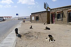 G219 in Barga Township, Tibet
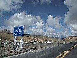 G219 in Burang, Tibet
 Few kilometers south of the border between Xinjiang and Tibet on the G219.
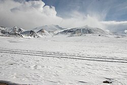 Same mountains as previous image but closer
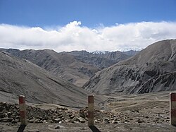 Heiqiazi Daban (Kirgizjangal Pass) in Kargilik County, Xinjiang
 Mazar Pass (Chiragsaldi Pass) in Kargilik County, Xinjiang
New route
เส้นทางดังกล่าวได้รับการขยายในแผนเครือข่ายทางหลวงแห่งชาติของจีน (2013–2030)ทั้งไปทางทิศเหนือและทิศตะวันออก เพื่อครอบคลุมชายแดนด้านตะวันตกและด้านใต้ของจีนทั้งหมด เส้นทางใหม่นี้จะมีความยาวกว่า10,000 กิโลเมตร (6,214 ไมล์)ทำให้เป็นทางหลวงแห่งชาติที่ยาวที่สุดเท่าที่เคยมีมา
ส่วนที่อยู่ตามแนวชายแดนจีน-เวียดนามยังเป็นที่รู้จักในชื่อทางหลวงเหยียนเปียน (沿边公路, แปลตรงตัวว่า: ทางหลวงตามแนวชายแดน ) [ 23 ] [ 24 ]
ตารางเส้นทาง

ดูเพิ่มเติม
- ทางหลวงแห่งชาติจีน
- ทางหลวงแห่งชาติจีนหมายเลข 228ซึ่งทอดยาวไปตามแนวชายฝั่งของประเทศจีน
- ทางหลวงแห่งชาติจีนหมายเลข 331ซึ่งทอดยาวไปตามแนวชายแดนทางเหนือของประเทศจีน
อ่านเพิ่มเติม
- Dorje, Gyurme. (2009). คู่มือรอยเท้าทิเบต (ฉบับที่ 4) Footprint Handbooks, Bath, อังกฤษ. ISBN 978-1-906098-32-2.
- "ทางหลวงแห่งชาติจีน หมายเลข219 หนึ่งในถนนที่สูงที่สุดในโลก" www.dangerousroads.org สืบค้นเมื่อ23 ธันวาคม 2021
- Arpi, Claude (13 มกราคม 2021). "การพัฒนาเชิงกลยุทธ์ที่ร้ายแรงที่สุดบนพรมแดนอินเดีย" . สืบค้นเมื่อ23 ธันวาคม 2021 –ผ่านทาง Indian Defence Review.
- Huttenback, RA (1964). "บันทึกทางประวัติศาสตร์เกี่ยวกับข้อพิพาทระหว่างจีนและอินเดียเหนืออักไซชิน"วารสารไชน่าไตรมาส 18 ( 18): 201– 207. doi : 10.1017/S0305741000041977 . ISSN 0305-7410 . JSTOR 3082130 . S2CID 155074304 .
- ความฝันแห่งดินแดนหิมะปักกิ่ง:สำนักพิมพ์ภาษาต่างประเทศ2005 หน้า279-294ISBN 7-119-03883-4–ผ่านทางInternet Archive
ลิงก์ภายนอก
 สื่อที่เกี่ยวข้องกับทางหลวงแห่งชาติจีนหมายเลข 219 ในวิกิมีเดียคอมมอนส์
 งานที่เกี่ยวข้องกับ公路网规划(2013年-2030年)ที่วิกิซอร์ซ
- ทางหลวงซินเจียง-ทิเบต (เย่เฉิง-บูรัง)
- The Highway 219 from Yecheng over Western Tibet to KathmanduArchived 9 December 2009 at the Wayback Machine Description and profile of the route.
- From Kashgar to Lhassa Photos along highway 219 (text in French).
- Some photos along the Highway 219
- A detailed description of a bicycle ride along highway 219 with many photos
- Photographs of a 2018 trip along G219