
Vjosa
| VjosaΑώος (Aoös) | |
|---|---|
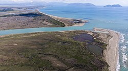 Mouth of Vjosa discharging into the Adriatic | |
 | |
| Location | |
| Countries | Albania and Greece |
| Physical characteristics | |
| Source | |
| • location | Pindus, Greece |
| Mouth | |
• location | Adriatic Sea, Albania |
• coordinates | 40°38′34″N19°19′2″E / 40.64278°N 19.31722°E |
• elevation | 0 m (0 ft) |
| Length | 272 kilometres (169 mi) |
Basin size | 6,706 km2 (2,589 sq mi) |
| Discharge | |
| • average | 195 m3/s (6,900 cu ft/s) |
The Vjosa (Albanian:[ˈvjɔsa]; indefinite form: Vjosë) or Aoös (Greek: Αώος) is a river in southwestern Albania and northwestern Greece. Its total length is about 272 kilometres (169 mi),[1] of which the first 80 kilometres (50 mi) are in Greece, and the remaining 192 kilometres (119 mi) in Albania.[2] Its drainage basin is 6,706 km2 (2,589 sq mi) and its average discharge is 195 m3/s (6,900 cu ft/s).[1] The main tributaries are Voidomatis, Sarantaporos, Drino and Shushicë.
The river arises in the Pindus mountains of Epirus, Greece, and generally flows northwest. It enters Albania near Çarshovë, and empties into the Adriatic Sea just north of Vlorë. Generally wild and unpolluted, the river is surrounded by the Vikos–Aoös National Park in Greece, and the Vjosa-Narta Protected Landscape near its mouth. In December 2020, the Albanian portion of the river was designated a "Managed Nature Reserve" by the government. A campaign by the environmentalist groups to designate the whole Albanian part of the course a national park, to guard against the prospective hydroelectric projects, ultimately resulted in the creation of the Vjosa Wild River National Park on 15 March 2023.[3][4][5][6]
Etymology
Vjosa เป็นที่รู้จักกันในชื่อต่างๆ มากมาย ในสมัยโบราณเรียกว่าAoös ( Ἄωος, Ἀῶος, Ἀῷος ) ในภาษากรีก (เช่น ในภูมิศาสตร์ของ Eratosthenes [ 7 ] ) และAousในภาษาละตินในภาษาแอลเบเนียเรียกว่าVjosëหรือVjosaในขณะที่ในกรีซเป็นที่รู้จักกันในชื่อโบราณ (Αώος ในการสะกดคำสมัยใหม่) ในแผนที่ละตินยุคกลางเรียกว่าViossaเช่นเดียวกับVovousa ( Βοβούσα ) หรือAias ( Αίας, Αἴας ) [ 8 ]ในภาษากรีกยังเป็นที่รู้จักในชื่อ Βοϊούσα (Voioussa ออกเสียงว่า vo-i-usa) โดยเฉพาะในตำราก่อนศตวรรษที่ 20 [ 9 ] [ 10 ]ตามที่นักประวัติศาสตร์ Ap. Vakalopoulos (1977) กล่าวไว้ ชื่อ Voioussa เป็นชื่อภาษากรีกทั่วไปของ Aoos [ 11 ]
Vjosaยังเป็นชื่อผู้หญิงชาวแอลเบเนียที่นิยมใช้กันทั่วไปอีกด้วย[ 12 ] [ 13 ] [ 14 ]
คอร์ส

แม่น้ำสายนี้มีต้นกำเนิดใน เทือกเขา พินดัสในเอพิรัสประเทศกรีซ ใกล้กับหมู่บ้านโววูซา [ 15 ] [ 16 ] มีการสร้างทะเลสาบเทียมขึ้นที่ระดับความสูง 1,350 เมตร (4,430 ฟุต) [ 17 ]ซึ่งมีเขื่อนไฟฟ้าพลังน้ำตั้งอยู่ตั้งแต่ปี 1987 แม่น้ำไหลผ่านหุบเขาของอุทยานแห่งชาติวิกอส-อาโอสจากนั้นไหลผ่านเมืองโคนิตซา ซึ่งมีแม่น้ำโวโด มาติสไหลมาบรรจบกัน แม่น้ำ ไหลเข้าสู่ประเทศแอลเบเนียใกล้กับหมู่บ้านวัลลาโฮ-ปซิลโลเตเรและโมลีฟโดสเกปาสโตสซึ่งมีแม่น้ำซารันตาโปรอสไหลมาบรรจบกันที่ชายแดนกรีซ-แอลเบเนีย จากนั้นไหลต่อไปทางตะวันตกเฉียงเหนือผ่านเมืองเปร์เมตเคลซีเรและเตเปเลเน (ซึ่งมีแม่น้ำดริโนไหล มาบรรจบกัน ) เมมาเลียจเซเลนิเซและโนโวเซเล จากนั้นแม่น้ำจะไหลลงสู่ทะเลเอเดรียติกทางตะวันตกเฉียงเหนือของเมืองวโลเรปากแม่น้ำตั้งอยู่ภายในเขตภูมิทัศน์คุ้มครอง Vjosa-Nartaในเดือนธันวาคม 2020 รัฐบาลได้กำหนดให้ส่วนของแม่น้ำ Vjosa ในประเทศแอลเบเนียเป็น "เขตอนุรักษ์ธรรมชาติที่มีการจัดการ" [ 18 ]
แม่น้ำสาขาหลักของ Vjosa ได้แก่ Voidomatis , Sarantaporos , DrinoและShushicë
เมืองหลักและเมืองต่างๆ ริมแม่น้ำ ได้แก่VovousaและKonitsaในกรีซ ตามลำดับปลายน้ำ และçarshovë , Përmet , Këlcyrë , Tepelenë , Memaliaj , SelenicëและNovoselëในแอลเบเนีย
ยุคโบราณ
หุบเขา Vjosa เป็นหนึ่งในเส้นทางธรรมชาติที่สำคัญที่สุดระหว่างพื้นที่ภูเขาตอนในของEpirus ไปจนถึง Illyriaตอนใต้และไปยังทะเลเอเดรียติกเส้นทางธรรมชาตินี้ต้องถูกใช้มานานหลายพันปีแล้ว และยังคงถูกใช้มาจนถึงปัจจุบัน[ 19 ] Hecataeus (550–476 ปีก่อนคริสตกาล) กล่าวถึงแม่น้ำนี้ว่าAias ( ภาษากรีกโบราณ : Αἴας ) ส่วนชื่อAnios ( Ἄνιος ) ถูกใช้โดยPlutarchในCaesar [ 20 ] ขณะที่Polybius , LivyและStraboใช้คำว่า Aoös

ในสมัยโบราณ ต้นน้ำของแม่น้ำตั้งอยู่ในเอพิรัส และปลายน้ำอยู่ในอิลลิเรีย[ 21 ] [ 22 ] [ 23 ]ร่วมกับเทือกเขาเซราเนียนส่วนแรกของแม่น้ำจนถึงบริเวณเทเปเลเนเป็นเส้นแบ่งเขตแดนระหว่างภูมิภาคคลาสสิกของอิลลิเรียและเอพิรัส และระหว่าง จังหวัด โรมันของเอพิรัสโนวาและเอพิรัสเวตุส [ 21 ] [ 22 ] [ 23 ] [ 24 ] [ 25 ] หุบเขาตอนล่างมีชนเผ่าพื้นเมืองอาศัยอยู่ ได้แก่ ชนเผ่าบิลลิโอเนสทางฝั่งขวา และชนเผ่าอามันเตสทางฝั่งซ้าย[ 21 ] [ 22 ] [ 26 ]ตั้งแต่กลางศตวรรษที่ 7 ก่อนคริสต์ศักราช พื้นที่อิลลีเรียนตอนใต้ของแม่น้ำอาอูสตอนล่างได้ประสบกับการเกิดขึ้นของศูนย์กลางเมืองยุคแรก ซึ่งรวมถึงป้อมปราการของคูเตคลอส มาชเค เซ มาร์เกลลิชและสตรัม บนฝั่งขวา และ ป้อมปราการ ของอามันเทีย มาฟโรเวและเทรปอร์ตบนฝั่งซ้าย[ 27 ]
Apollonia in Illyria was founded on the right bank near the mouth of the river around 600 BC by Greek colonists from Corinth and possibly Corcyra, who established a trading settlement on a largely abandoned coastal site by invitation of the local Illyrians.[28][29][30] It developed into an independent polis, and thrived throughout classical antiquity becoming one of the most important urban centres in the wider region, perhaps representing the most important of the several classical towns of the same name. The Thesprotian tribe of Parauaioi received their name from the river, as those living beside it. Pausanias writes of "sharks"[31] (Greek: θηρία) in the river, as it flows through Thesprotia. It is mentioned as Avos (Greek: Αύος) by Stephanus of Byzantium[32] in the sixth century AD.

In 274 BC Pyrrhus of EpirusdefeatedAntigonus II Gonatas near the river's banks. In 198 BC, Philip V of Macedon and the Roman Titus Quinctius Flamininus, clashed in the Battle of the Aous. In 170 BC a plot to kidnap Aulus Hostilius Mancinus was foiled by Molossians by mistake.[33]
Conservation
Greece
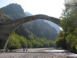
The Vikos–Aoös National Park (Greek: Εθνικός Δρυμός Βίκου–ΑώουEthnikós Drymós Víkou–Aóou), created in 1973, is a national park in Epirus in northwestern Greece and UNESCO Geopark. The national park encompasses 126 square kilometres (31,135 acres) of mountainous terrain, with numerous rivers, lakes, caves, canyons, and coniferous and deciduous forest. The core of the 3,400 hectare park[34] is the Vikos Gorge, carved by the Voidomatis River, while the Aoos Gorge, Mount Tymfi, with its highest peak, Gamila, at 2,497 metres (8,192 ft), and a number of settlements forming the park's peripheral zone.
Albania
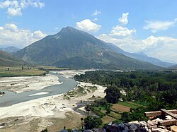
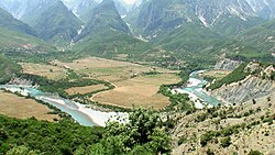

In February 2005, the Albanian government made the Vjose-Narte wetlands a protected area. This legislation followed Albania's ratification of the Kyoto Protocol in December 2004. The river contributes water to the Vjosë-Levan-Fier irrigation canal, a canal that was built in the 1950s to irrigate the Myzeqe. In December 2020, the Albanian portion of the river was designated a "Managed Nature Reserve" by the Albanian government.[18]
The Vjosa's potential for hydropower has attracted developers to submit proposal to planning authorities for dam projects along the river and its tributaries. By 2017, over 2000 dam projects had gained governmental approval on stretches of river throughout the Balkans, including the Vjosa's channel.[35] Developers have met with opposition from European nature organisations including RiverWatch, EuroNatur,[36] and EcoAlbania.[37]
A 2012 study assessed the hydromorphology of the Balkan's rivers, taking into account the structural status of 35,000 river kilometres. The study showed that the region's rivers are largely intact, with 30% deemed pristine and 50% slightly modified.[38]
In February 2020, a campaign to elevate the status of the Vjosa watershed to Vjosa National Park gained approval from 20 environmental groups under the leadership of EcoAlbania. The effort to create Europe's first wild river park and save 300 km of rivers and streams targeted several projects identified in a February 2021 proposal.[39]
In September 2020, Albanian prime minister Edi Rama announced that a protected area will be created around the Vjosa. In December 2020, the Albanian government designated the Vjosa River as a "Managed Nature Reserve" or nature park.[18] Environmental groups are skeptical of the level of protection afforded by "protected" status. A national park designation would prohibit hydroelectric projects, airports, and other development; a protected area designation would not.[2]
ในเดือนเมษายน พ.ศ. 2564 มีการยื่นคำร้องที่ลงนามโดยนักวิทยาศาสตร์แม่น้ำ Vjosa ต่อประธานาธิบดี Ilir Meta ของแอลเบเนีย[ 40 ]ความกังวลเร่งด่วนของนักวิทยาศาสตร์คือแผนการของบริษัทร่วมทุนตุรกี-แอลเบเนียAyen ALBที่จะสร้างเขื่อนไฟฟ้าพลังน้ำสูง 50 เมตร ซึ่งจะเป็นการพัฒนาครั้งแรกที่จะเปลี่ยนเส้นทางของแม่น้ำส่วน 200 กิโลเมตรของแอลเบเนีย เขื่อนจะทำให้พื้นที่ที่มีสัตว์และพืช 1,175 ชนิดอาศัยอยู่ ซึ่งบางชนิดใกล้สูญพันธุ์ ถูกน้ำท่วม จะทำลายพื้นที่เกษตรกรรม ทำลายแหล่งประมงของแม่น้ำ และบังคับให้ผู้คนหลายพันคนต้องอพยพออกจากบ้าน นักเคลื่อนไหวกล่าวว่ารัฐบาลควรให้ความสำคัญกับแหล่งพลังงานหมุนเวียนอื่น ๆ ที่สร้างความเสียหายต่อสิ่งแวดล้อมน้อยกว่า[ 2 ]
เมื่อวันที่ 15 มีนาคม พ.ศ. 2566 แม่น้ำ Vjosa ได้กลายเป็นอุทยานแห่งชาติที่ได้ รับการคุ้มครองภายใต้ชื่ออุทยานแห่งชาติแม่น้ำ Vjosa Wild [ 41 ]
ลุ่มน้ำ
- ◆ไหลผ่านประเทศกรีซ
|
ดูเพิ่มเติม
ลิงก์ภายนอก

- เว็บไซต์อย่างเป็นทางการของพิพิธภัณฑ์นิเวศวิทยาแม่น้ำวีโยซา/อาอูส