
ย่านใจกลางเมืองสไตล์วิคตอเรียนของลอสแอนเจลิส

ย่านดาวน์ทาวน์ของลอสแอนเจลิส ใน ช่วงปลายยุควิกตอเรียในปี 1880 ตั้งอยู่ใจกลางบริเวณปลายสุดทางใต้ของจัตุรัสลอสแอนเจลิสและในอีกสองทศวรรษต่อมา ย่านนี้ได้ขยายไปทางใต้และตะวันตกตามถนนเมนถนนสปริงและถนนบรอดเวย์ไปยังถนนเธิร์ด อาคารส่วนใหญ่ในศตวรรษที่ 19 ไม่เหลืออยู่แล้ว เหลืออยู่เพียงในบริเวณจัตุรัสหรือทางใต้ของถนนเซคันด์เท่านั้น ส่วนที่เหลือถูกรื้อถอนเพื่อสร้างย่านศูนย์กลางเมือง ซึ่งประกอบด้วย ศาลากลาง ศาลหลายแห่ง และอาคารเทศบาล เทศมณฑล รัฐ และรัฐบาลกลางอื่นๆ รวมถึงจัตุรัสไทม์ส มิเรอร์ [ 1 ] [ 2 ] บทความนี้ครอบคลุมพื้นที่ดังกล่าว ระหว่างจัตุรัส ถนนเธิร์ด ถนนลอสแอนเจลิส และถนนบรอดเวย์ ในช่วงปี 1880 จนถึงช่วงเวลาของการรื้อถอน (ทศวรรษ 1920–1950)
ในช่วงเวลานั้น (ช่วงปี ค.ศ. 1880–1900) พื้นที่ดังกล่าวถูกเรียกว่าศูนย์กลางธุรกิจ ย่านธุรกิจ หรือเขตธุรกิจ เมื่อถึงปี ค.ศ. 1910 พื้นที่ดังกล่าวถูกเรียกว่า "North End" ของเขตธุรกิจ ซึ่งในขณะนั้นได้ขยายไปทางใต้สู่บริเวณที่ปัจจุบันเรียกว่าHistoric Coreตามแนวถนนบรอดเวย์ สปริง และเมน โดยประมาณจากถนนสายที่ 3 ถึงสายที่ 9 [ 3 ]
ที่ตั้ง

ในช่วงกลางทศวรรษ 1890 ถนนเฟิร์สต์และสปริงเป็นศูนย์กลางของย่านธุรกิจอาคารแบรดเบอรีเปิดทำการในปี 1893 ที่ถนนเธิร์ดและบรอดเวย์ และยังคงตั้งอยู่จนถึงทุกวันนี้[ 4 ]ในปี 1910 พื้นที่ทางเหนือของถนนโฟร์ทถือเป็น "นอร์ทเอนด์" ของย่านธุรกิจ และเริ่มมีข้อกังวลเกี่ยวกับการเสื่อมโทรม เนื่องจากศูนย์กลางการค้าได้ย้ายไปยังพื้นที่ที่ปัจจุบันรู้จักกันในชื่อHistoric Coreซึ่งอยู่ระหว่างถนนเธิร์ดถึงถนนไนน์[ 5 ]
แผนที่
แผนที่แสดงผังถนนในปี 1910 และแสดงด้วยสีน้ำเงินถึงการเปลี่ยนแปลงแนวถนนที่สำคัญสามจุดซึ่งเกิดขึ้นในช่วงทศวรรษ 1920-1950:
- มีการปรับแนวถนน Spring Street ทางเหนือของถนน First Street ให้ขนานกับถนน Main Street
- ถนนเทมเปิลสตรีทส่วนต่อขยายไปทางทิศตะวันออกจากถนนเมนสตรีท
- การก่อสร้างทางหลวงหมายเลข US-101 และถนนบริการที่เชื่อมต่อกัน ซึ่งเรียกว่าถนนอาร์คาเดียและถนนอลิโซ แต่ไม่ได้อยู่ตรงตำแหน่งเดียวกับถนนอาร์คาเดียและถนนอลิโซเดิม
ภาพรวมของพื้นที่


อาคาร
บรอดเวย์
 ภาพถ่ายปี 1905 มองไปทางทิศใต้ของถนนบรอดเวย์จากเทมเปิล โรงพิมพ์ไทมส์มิเรอร์อยู่ด้านหน้า มีป้ายบอกว่า 110 นอร์ทบรอดเวย์ ศาลาว่าการเมืองที่สร้างในปี 1888 ตั้งตระหง่านอยู่ไกลออกไปบนถนนบรอดเวย์ช่วงบล็อกที่ 200 เนินเขาฟอร์ ตมัวร์ ซึ่งปัจจุบันถูกปรับให้ราบเรียบแล้ว อยู่ทางด้านขวา
 ประมาณปี ค.ศ. 1893–1900 มองไปทางทิศตะวันออกที่ถนนบรอดเวย์เลียบไปตามถนนเธิร์ดจากเนินบันเกอร์ฮิลล์
เทมเปิลและบรอดเวย์
รถรางเคเบิลของTemple Street Cable Railwayวิ่งไปตามถนน Temple Street ตั้งแต่ปี พ.ศ. 2429 และถูกแทนที่ด้วย รถราง Pacific Electricในปี พ.ศ. 2445 [ 6 ] [ 7 ]
มุมตะวันตกเฉียงเหนือ
 สมาคมสตรีคริสเตียนเพื่อการงดดื่มสุรา (Women's Christian Temperance Union Temple), ค.ศ. 1890
- อาคาร อิฐสามชั้นของสมาคมสตรีคริสเตียนเพื่อการงดดื่มสุราถูกสร้างขึ้นในปี พ.ศ. 2431 ด้วยงบประมาณ 45,000 ดอลลาร์[ 8 ]หรือที่รู้จักกันในชื่อวิหารแห่งการงดดื่มสุราอาคารนี้ถูกรื้อถอน[ 9 ]และถูกแทนที่ในปี พ.ศ. 2490 ด้วยโรงงานทำความร้อนและทำความเย็นส่วนกลางของเทศมณฑลลอสแอนเจลิส[ 10 ]
มุมตะวันออกเฉียงใต้
 โรงเรียนมัธยมปลายลอสแอนเจลิสบนเนินปอนด์เค้ก ในช่วงทศวรรษ 1870
 อาคารศาลและที่ทำการไปรษณีย์ "หินแดง" (ค.ศ. 1891-1936)
 หอจดหมายเหตุ (ค.ศ. 1911–1973)
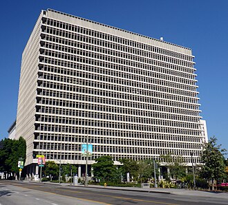 ศาลคลาร่า ชอร์ทริจ โฟลทซ์
สถานที่แห่งนี้ในขณะนั้นรู้จักกันในชื่อ Pound Cake Hill อาคารที่ตั้งอยู่ที่นี่หันหน้าไปทาง New High Street ทางทิศตะวันออกและ Broadway ทางทิศตะวันตก มีดังต่อไปนี้: [ 11 ]
- โรงเรียนมัธยมลอสแอนเจลิส (Los Angeles High School ) ซึ่งเดิมตั้งอยู่ระหว่างโรงเรียนนิวไฮ (New High) ทางทิศตะวันตกและถนนบรอดเวย์ (Broadway) ทางทิศตะวันออก ทางใต้ของถนนเทมเปิล (Temple Street) ต่อมาได้ย้ายไปอยู่ที่ถนนแคลิฟอร์เนีย (California) และถนนแซนด์ (Sand Street) และในปี 1890 ได้สร้างอาคารใหม่บนเนินฟอร์ตมัวร์ (Fort Moore Hill ) ทางทิศเหนือของจุดที่ถนนบรอดเวย์ตัดกับทางด่วนฮอลลีวูด (Hollywood Freeway) ในปัจจุบัน ส่วนโรงเรียนบนเนินปอนด์เค้ก (Pound Cake Hill) ถูกรื้อถอนและสร้างใหม่เป็น:
- ประการแรก คือศาลหินแดง (หรือ "ศาลหินทรายแดง") ซึ่งทำหน้าที่เป็นศาลต่อจากศาลหอนาฬิกา (หรือที่เรียกว่าศาลเทมเปิล) ศาลแห่งนี้ได้รับความเสียหายจนไม่สามารถซ่อมแซมได้จากเหตุการณ์แผ่นดินไหวที่ลองบีชในปี 1933 และถูกรื้อถอนในปี 1936
- อาคารสำนักงานทะเบียนประวัติศาสตร์ประจำเทศมณฑลลอสแอนเจลิส (สร้างในปี 1911)ถูกสร้างขึ้นติดกับ (ทางใต้ของ) ศาลหินทรายแดงในปี 1911 อาคารดังกล่าวถูกพิจารณาว่าไม่ปลอดภัยหลังจากเกิดแผ่นดินไหวที่ซานเฟอร์นันโดในปี 1971และถูกรื้อถอนในปี 1973
ขณะนี้บนเว็บไซต์มีรายการดังต่อไปนี้:
- ศูนย์ยุติธรรมทางอาญาคลารา ชอร์ทริจ โฟลทซ์ (คณะลูกขุนใหญ่ประจำเทศมณฑลลอสแอนเจลิส) ซึ่งเดิมรู้จักกันในชื่ออาคารศาลอาญา เปิดทำการในปี 1972
- ส่วนหนึ่งของแกรนด์พาร์คซึ่งทอดยาวกลางบล็อกระหว่างถนนเทมเปิลและถนนเฟิร์สต์ จากศาลาว่าการเมืองที่ถนนสปริง ไปจนถึงศูนย์ดนตรีที่ถนนแกรนด์อเวนิว
มุมตะวันตกเฉียงใต้
- สำนักงานทะเบียนประวัติศาสตร์ประจำเทศมณฑลลอสแอนเจลิสแห่งที่สองเปิดทำการในปี 1962
ทางด้านทิศใต้ บริเวณกลางบล็อก เป็นส่วนหนึ่งของแกรนด์พาร์ค
เฟิร์สแอนด์บรอดเวย์
 ภาพถ่ายมองไปทางทิศใต้ตามถนนบรอดเวย์จากถนนเฟิร์สท์ ในปี 1904-1905 ด้านขวา จากซ้ายไปขวา: อาคารซี.เอช. ฟรอสต์ (141-143), อาคารโรอาโนคที่มีหอคอย, อาคารนิวเวลล์แอนด์แกมมอน, โรงละครเมสันโอเปรา ด้านซ้ายคือหอการค้า และศาลาว่าการเมืองในปี 1888
มุมตะวันออกเฉียงเหนือ
 อาคารลอสแอนเจลิสไทมส์ปี ค.ศ. 1886
- อาคาร Los Angeles Timesปี ค.ศ. 1886 อาคารนี้ถูกรื้อถอนหลังจากการวางระเบิดในปี ค.ศ. 1910และสำนักงานใหญ่แห่งใหม่ได้เปิดทำการในสถานที่แห่งนี้ในปี ค.ศ. 1912 ต่อมาหนังสือพิมพ์ได้ย้ายไปทางใต้บนถนน Spring Street ไปยังอาคารLos Angeles Timesซึ่งปัจจุบันเป็นส่วนหนึ่งของTimes Mirror Squareโดยครอบคลุมพื้นที่ทั้งบล็อกระหว่างถนน Broadway, Spring, First และ Second [ 12 ]
มุมตะวันตกเฉียงเหนือ
- ที่ตั้งของอาคาร Tajo (ค.ศ. 1896–กลางศตวรรษที่ 20) [ 13 ]ปัจจุบันเป็นที่ตั้งของห้องสมุดกฎหมายเทศมณฑลลอสแอนเจลิส[ 4 ]
มุมตะวันออกเฉียงใต้และด้านตะวันออกของบล็อกที่ 100
 ไทม์ส มิเรอร์ สแควร์ปี 1973 ส่วนต่อเติมเปเรย์รา
 โปสการ์ดประมาณปี 1910 ของหอการค้า
- ที่ตั้งของอาคารค้าปลีกและสำนักงานCulver Block [ 14 ]ปัจจุบันเป็นที่ตั้งของTimes Mirror Square 1973 Pereira Addition ซึ่งตั้งชื่อตามWilliam Pereiraที่ ออกแบบ
- ทางใต้ของ Culver Block คืออาคารหอการค้าลอสแอนเจลิสเลขที่ 128–130 S. Broadway เปิดทำการเมื่อวันที่ 12 กุมภาพันธ์ พ.ศ. 2447 [ 15 ]ซึ่งถือเป็นแลนด์มาร์คในสมัยนั้น โดยปรากฏอยู่ในโปสการ์ดและหนังสือต่างๆ อาคารมี 6 ชั้น 4 ห้อง สำนักงานที่ชั้นล่างประกอบด้วยสำนักงานของLos Angeles Heraldและ Consolidated Bank [ 16 ]
มุมตะวันตกเฉียงใต้
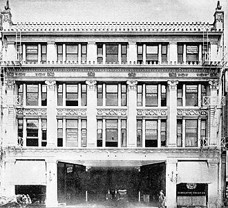
 จากซ้ายไปขวา: อาคาร CH Frost, อาคาร Roanoke, อาคาร Newell & Gammon และโรงละคร Mason Opera House
มุมตะวันตกเฉียงใต้ ซึ่งในสมัยวิคตอเรียเป็นที่ตั้งของอาคารค้าปลีกและสำนักงานที่ไม่โดดเด่นนัก ต่อมาในปี 1958 เป็นที่ตั้งของอาคารสำนักงานรัฐ (ปี 1958-1960 ออกแบบโดยสถาปนิก Anson C. Boyd ถูกรื้อถอนในปี 2006) อาคารนี้มีชื่อว่าอาคารสำนักงานรัฐจูนิเปโร เซอร์ราและชื่อนี้จะถูกนำไปใช้กับอาคารห้างสรรพสินค้าบรอดเวย์ เดิม ที่หัวมุมถนนที่ 4 และบรอดเวย์ เมื่อเปิดทำการเพื่อแทนที่อาคารนี้ในปี 1998 [ 17 ]ปัจจุบันเป็นที่ตั้งของศาลสหรัฐแห่งใหม่ที่สร้างขึ้นในปี 2016 ซึ่งกินพื้นที่ทั้งบล็อกระหว่างถนนบรอดเวย์ ถนนฮิลล์ ถนนเฟิร์สต์ และถนนเซคันด์[ 18 ]
ทางใต้ของมุมตะวันตกเฉียงใต้เล็กน้อยคือโรงละครเมสันเลขที่ 127 ถนนบรอดเวย์ใต้ เปิดทำการในปี 1903 ในชื่อโรงละครโอเปร่าเม สัน มีที่นั่ง 1,600 ที่นั่ง เบน จามิน มาร์แชลล์จากบริษัทมาร์แชลล์ แอนด์ วิลสัน ในชิคาโก ออกแบบอาคารร่วมกับจอห์น พาร์กินสันมาร์แชลล์เป็นที่รู้จักจากการออกแบบโรงละครอิโรควอยส์ในชิคาโก ได้รับการปรับปรุงใหม่ในปี 1924 โดยเมเยอร์ แอนด์ ฮอลเลอร์ต่อมาในชื่อโรงละครเมสัน ได้ฉายภาพยนตร์ภาษาสเปน ถูกรื้อถอนในปี 1955 [ 19 ]
145 S. Broadway [ 20 ]ที่ตั้งของอาคาร CH Frostซึ่งต่อมาเป็นที่รู้จักในชื่ออาคาร Haig M. Princeสร้างขึ้นในปี 1898 โดยสถาปนิกJohn Parkinson [ 21 ] ปัจจุบัน เป็นที่ตั้งของศาลสหรัฐอเมริกาแห่งใหม่ที่สร้างขึ้นในปี 2016 ซึ่งกินพื้นที่ทั้งบล็อกระหว่าง Broadway, Hill, First และ Second [ 18 ]
เซคันด์แอนด์บรอดเวย์
 ภาพถ่ายถนนบรอดเวย์มองไปทางทิศใต้จากถนนสายที่ 2 ระหว่างปี 1895-1905
มุมตะวันออกเฉียงเหนือ
 อาคารเฮลแมน ปี 1918
หนึ่งในอาคาร Hellman หลายแห่ง ทั่วดาวน์ทาวน์แอลเอ — อย่าสับสนกับอาคาร Hellman ที่ยังคงมีอยู่ ที่ Fourth และ Spring — ตั้งอยู่ที่นี่ (#138) ตั้งแต่ปี 1897 ถึง 1959 [ 22 ]ปัจจุบันสถานที่แห่งนี้เป็นอาคารจอดรถ ซึ่งเป็นส่วนหนึ่งของคอมเพล็กซ์Times Mirror Square
มุมตะวันตกเฉียงใต้และด้านตะวันตกของบล็อกที่ 200
 อาคารธนาคารแห่งชาติอเมริกัน มุมตะวันตกเฉียงใต้ ปี 1890 ทางด้านซ้ายเป็นหอคอยและหน้าจั่วสองด้านของอาคาร YMCA (ปี 1889) จากนั้นเป็นอาคาร Potomac Block (ปี 1890)
 อาคาร Merchants Trust Company ปี 1910
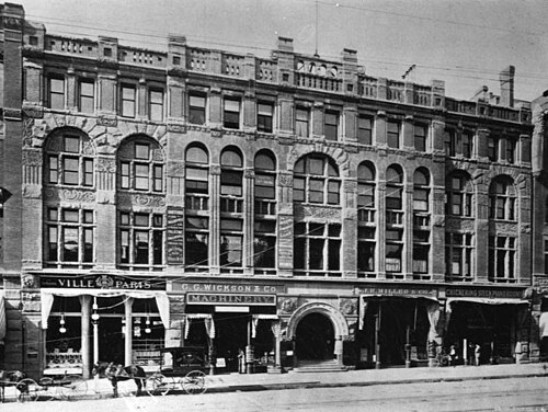 บล็อกโพโทแมค ประมาณปี ค.ศ. 1890-1895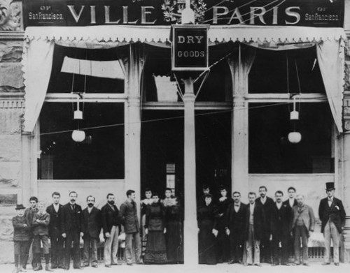
 อาคาร Boston Dry Goods และ Harris Newmark (Blanchard Hall) ปี 1899
ฝั่งตะวันตกของถนนเซาท์บรอดเวย์ช่วงบล็อกที่ 200 มีบทบาทสำคัญในประวัติศาสตร์การค้าปลีกของลอสแอนเจลิสตั้งแต่ปี 1893 ถึง 1917 เนื่องจากเป็นที่ตั้งของห้างสรรพสินค้าชื่อดังหลายแห่งในช่วงแรก เช่น ห้างสรรพสินค้า Ville de ParisของCoulterตั้งแต่ปี 1905 ถึง 1917 และ ร้าน "Boston Dry Goods" ของ JW Robinsonตั้งแต่ปี 1895 ถึง 1915 ห้างสรรพสินค้าทั้งสามแห่งนี้ได้ย้ายไปอยู่ที่ถนนเซเว่นท์สตรี ท เมื่อถนนสายนี้กลายเป็นถนนช้อปปิ้งระดับหรูระหว่างปี 1915 ถึง 1917
- บ้านของท่านผู้พิพากษาโอเมลเวนีสร้างขึ้นในปี 1870 ตั้งอยู่บริเวณมุมตะวันตกเฉียงใต้ของถนนสายที่ 2 และถนนบรอดเวย์ ต่อมาถูกแทนที่ด้วยอาคารธนาคาร อเมริกันเนชั่นแนลแบงก์ (ภายหลังคือธนาคารแคลิฟอร์เนียแบงก์ ) ซึ่งต่อมาถูกแทนที่ด้วยอาคารแคลิฟอร์เนียในปี 1911 ปัจจุบันเลขที่ 201-213 บนถนนบรอดเวย์ เป็นที่รู้จักในชื่อศูนย์สื่อบรอดเวย์ (Broadway Media Center )
ถัดไปทางทิศใต้บนฝั่งตะวันตกของถนนบรอดเวย์ คืออาคารเลขที่ 207–211 ซึ่งเป็นที่ตั้งของ:
- อาคาร YMCA (เลขที่ 207–209–211) สถาปัตยกรรมแบบโรมาเนสก์ เปิดใช้งานในเดือนกรกฎาคม ค.ศ. 1889 และถูกรื้อถอนในปี ค.ศ. 1903
- สมาคม YMCA ดำเนินการอยู่ที่หมายเลข 207 แห่งนี้ตั้งแต่ปี 1889 จนถึงปี 1903
- ห้างสรรพสินค้า ซิตี้ออฟลอนดอนเปิดทำการที่นี่ในเดือนสิงหาคม พ.ศ. 2434 โดยมีนายไฮลส์และนายนิคคอลส์เป็นผู้บริหาร ซึ่งมาจาก ห้างสรรพสินค้า ซิตี้ออฟปารีส ห้างนี้จำหน่ายผ้าม่าน มู่ลี่ ผ้าห่มนวม และอื่นๆ[ 23 ]ดำเนินกิจการอยู่ที่นี่จนถึงเดือนสิงหาคม พ.ศ. 2438 จากนั้นจึงย้ายไปอยู่ที่อาคารโพโทแมคหมายเลข 213 ซึ่งอยู่ติดกัน[ 24 ]
อาคาร YMCA ถูกรื้อถอนเพื่อสร้างสิ่งต่อไปนี้:
- อาคารMerchants Trust Co. [ 25 ]
คอมเพล็กซ์ของคูลเตอร์
อาคารPotomac BlockและBicknell Block ที่อยู่ติดกัน เดิมทีเป็นที่ตั้งของร้านค้าปลีกที่มีชื่อเสียงในยุคนั้น ต่อมาในปี 1906 ห้างสรรพสินค้า Coulter's ได้รวมเข้าด้วยกัน เพื่อสร้างเป็นศูนย์การค้า โดยเปิดเป็นร้านค้าใหม่ขนาด 157,000 ตารางฟุต (14,600 ตารางเมตร) ในเดือนมิถุนายน ปี 1905 [ 26 ] [ 27 ] [ 28 ]
บล็อกโพโทแมค
อาคารPotomac Blockเลขที่ 213–223 S. Broadway เป็นที่รู้จักกันในชื่ออาคาร BF Coulter ตั้งแต่ปี พ.ศ. 2448 ถึง พ.ศ. 2460 เดิมทีอาคารนี้ได้รับการพัฒนาโดย JM Griffith เจ้าของโรงเลื่อยและโรงสี ออกแบบในปี พ.ศ. 2431 โดยBlock, Curlett และ Eisenในรูปแบบสถาปัตยกรรมโรมาเนสก์[ 29 ] และเปิดทำการเมื่อวันที่ 17 กรกฎาคม พ.ศ. 2433 [ 30 ]
ผู้เช่าประกอบด้วย:
- ห้างสรรพสินค้า Ville de Paris (ที่ 221–223 ตั้งแต่ปี พ.ศ. 2436 ถึง พ.ศ. 2449) [ 29 ]
- บริษัท City of London Dry Goods Co. ซึ่งย้ายมาที่นี่จากที่อยู่ติดกันที่หมายเลข 211 ในเดือนสิงหาคม พ.ศ. 2438 และลงโฆษณาสำหรับสถานที่นี้จนถึงเดือนสิงหาคม พ.ศ. 2442 [ 24 ]
นับเป็นครั้งแรกที่ร้านค้าปลีกขนาดใหญ่เปิดสาขาบนถนนเซาท์บรอดเวย์ ซึ่งเป็นจุดเปลี่ยนสำคัญของย่านช้อปปิ้งระดับไฮเอนด์ในช่วงปี 1890 ถึง 1905 จากบริเวณถนนเฟิร์สต์และสปริง มาอยู่ที่ถนนเซาท์บรอดเวย์ ในปี 1904 คูลเตอร์สได้ซื้ออาคารโพโทแมคบล็อก และรวมเข้ากับอาคารบิกเนลล์บล็อกเพื่อสร้างร้านค้าใหม่ซึ่งเปิดทำการในปี 1905
หลังจากที่คูลเตอร์ย้ายออกไป:
- อาคารเลขที่ 215 ยังคงเป็นสาขาของ Coulter's จนถึงปี 1927 จากนั้น อาคารเลขที่ 215–217 ก็กลายเป็นที่ตั้งของ Pacific Furniture House ในช่วงทศวรรษ 1940
- อาคารเลขที่ 219 เคยเป็นที่ตั้งของห้างสรรพสินค้าฟิชช์ในช่วงทศวรรษ 1940
อาคารหลังนี้ถูกรื้อถอนในปี พ.ศ. 2496 และปัจจุบันเป็นที่ตั้งของลานจอดรถ[ 31 ]
บล็อกบิกเนลล์
อาคารBicknell Block (หรือ Bicknell Building) ที่ 225–229 S. Broadway โดยมีทางเข้าด้านหลังอยู่ที่ 224–228 S. Hill Street เคยเป็นส่วนหนึ่งของ Coulter's ตั้งแต่ปี 1905 ถึง 1917 หลังจากที่ Coulter's ย้ายออกไปในปี 1917 อาคารนี้ก็เป็นที่ตั้งของWestern Shoe Co. (จนถึงปี 1922) ซึ่งต่อมาเป็นที่รู้จักในชื่อ Western Department Store (1922–1928) ตัวอักษรที่ปกคลุมด้านหน้าของอาคารตั้งแต่บนลงล่างจนถึงปลายทศวรรษ 1950 เขียนว่า "แผนกรองเท้าที่ใหญ่ที่สุดในภาคตะวันตก" [ 32 ]
ลงไปทางใต้อีก
- อาคาร เลขที่ 231-235 อาคารแฮร์ริส นิวมาค (อาคารแบลนชาร์ด ฮอลล์ ดนตรีและศิลปะ ปี 1899 ออกแบบโดย อับราม เอเดลแมน) บริษัทบาร์ตเลตต์ มิวสิค (เลขที่ 233) ส่วนต่อขยายของร้านเจดับบลิว โรบินสัน (เลขที่ 235) ร้านกู๊ดวิลล์ อินดัสทรีส์ (เลขที่ 233-235 ช่วงปี 1950-1960) อาคารยังคงตั้งอยู่ แต่ทุกชั้นยกเว้นชั้นล่างสุดถูกรื้อออกไปแล้ว
- 237-241 อาคาร Boston Dry Goods (สร้างเสร็จในปี 1895 ถูกรื้อถอน สถาปนิกคือTheodore EisenและSumner Huntผู้ออกแบบอาคาร Bradbury ) [ 33 ] [ 34 ]อาคารนี้เคยเป็นที่ตั้งของ ร้าน "Boston Dry Goods" ของ JW Robinsonตั้งแต่ปี 1895 ถึง 1915 ห้างสรรพสินค้า Scott's (239–241 ในช่วงทศวรรษ 1920) และร้าน Third Street Store (237–241 ในช่วงทศวรรษ 1950–60) ถูกรื้อถอน ปัจจุบันเป็นที่ตั้งของลานจอดรถ
- เลขที่ 251 เป็นที่ตั้งของห้างสรรพสินค้าเฉพาะทางI. Magnin ซึ่งเปิดทำการที่นี่เมื่อวันที่ 2 มกราคม พ.ศ. 2442 [ 35 ]ตั้งแต่ปี พ.ศ. 2447 I. Magnin ได้ประกาศว่าห้างสรรพสินค้าแห่งนี้จะใช้ชื่อตามผู้จัดการของตน คือMyer Siegel [ 36 ]
มุมตะวันออกเฉียงใต้และด้านตะวันออกของบล็อกที่ 200
 มองไปทางทิศเหนือตามถนนบรอดเวย์ ฝั่งตะวันออก ผ่านถนนสายที่ 2 จากซ้ายบน: อาคาร Los Angeles Times, อาคาร Hall of Records ปี 1911 ด้านหลัง, อาคาร Chamber of Commerce, อาคาร Hellman, อาคาร Nolan, Smith and Bridge, อาคาร Gordon, อาคาร Crocker, อาคาร Copp, ศาลาว่าการเมืองปี 1888
 ศาลาว่าการเมืองลอสแอนเจลิส (ค.ศ. 1888–1928)
 วัดบไนบริท (เปิดเมื่อปี 1873)
บริเวณมุมตะวันออกเฉียงใต้ของถนนสายที่ 2 และถนนบรอดเวย์ เคยเป็นที่ตั้งของ:
- โบสถ์เพรสไบทีเรียนแห่งแรกในปี พ.ศ. 2337 [ 37 ]โบสถ์แห่งนี้ถูกแทนที่ในช่วงเวลาก่อนปี พ.ศ. 2449
- อาคารโนแลน สมิธ และบริดจ์เลขที่ 200-4 ถนนบรอดเวย์ใต้ มีร้านค้าและร้านอาหาร[ 38 ]
- ปัจจุบัน บริเวณหัวมุมถนนแห่งนี้เป็นที่ตั้งของสถานีรถไฟฟ้ารางเบาใต้ดินประวัติศาสตร์บรอดเวย์
ในช่วงกลางเกมมีผู้เล่นดังนี้:
- อาคารคร็อกเกอร์เลขที่ 212–6 [ 39 ]เป็นที่ตั้งของบริษัท Victor Clothingตั้งแต่ปี 1920 ถึง 1964
- วิหาร B'nai B'rith (ค.ศ. 1873) เลขที่ 214 ถนนบรอดเวย์ใต้ (การกำหนดหมายเลขหลังปี ค.ศ. 1890) ซึ่งเป็นโบสถ์ยิวแห่งแรกของเมือง ถูกรื้อถอนเพื่อสร้างอาคาร Copp เลขที่ 218–224 ถนนบรอดเวย์ใต้ ซึ่งเป็นที่ตั้ง ของร้านขายขนมและร้านน้ำชาPig 'n Whistleดั้งเดิม (ค.ศ. 1908) [ 40 ]ร้าน Pig 'n Whistle จะเปิดสาขาที่ถนนเซเว่นท์และบรอดเวย์ และในฮอลลีวูด ซึ่งต่อมาได้กลายเป็นร้านอาหารที่เป็นแลนด์มาร์คและยังคงเปิดให้บริการอยู่ในปัจจุบัน
- ศาลาว่าการเมือง (ค.ศ. 1888–1928; เปิดทำการในปี ค.ศ. 1888 รื้อถอนในปี ค.ศ. 1929; 228–238 ถนนเซาท์บรอดเวย์ สถาปนิก โซโลมอน เอิร์มเชอร์ ฮาสสถาปัตยกรรมโรมาเน สก์) ปัจจุบันเป็นลานจอดรถ อาคารมีสามชั้น และมี หอระฆังสูง 150 ฟุต (46 เมตร) สร้างด้วยอิฐสีแดงและสีน้ำตาล เคยเป็นที่ตั้งของห้องสมุดสาธารณะลอสแอนเจลิสอยู่ช่วงหนึ่ง จนกระทั่งย้ายไปยัง อาคารห้างสรรพสินค้า แฮมเบอร์เกอร์ แห่งใหม่ ที่ถนนเอทและบรอดเวย์ในปี ค.ศ. 1908 [ 41 ]ปัจจุบันพื้นที่ดังกล่าวเป็นส่วนหนึ่งของอาคารจอดรถ "(213) ถนนเซาท์สปริง" [ 4 ]
- อาคาร Hosfieldหมายเลข 240-246 ซึ่งเป็นที่ตั้งของNatatorium (สระว่ายน้ำในร่ม) ในปี 1894 และร้านอาหาร Imperialในปี 1906 [ 39 ]หลังจากปี 1964 เป็นที่ตั้งของVictor Clothing ซึ่งโดดเด่นด้วยภาพจิตรกรรมฝาผนังที่เปลี่ยนแปลงไปเรื่อยๆ ซึ่งสะท้อนถึงวัฒนธรรม Chicanoในท้องถิ่นVictor Clothing ดำเนินกิจการที่นี่จนถึงปี 2001 และเป็นที่รู้จักจากการโฆษณาบ่อยครั้งทางโทรทัศน์ภาษาสเปน[ 42 ]
เธิร์ดแอนด์บรอดเวย์
มุมตะวันตกเฉียงเหนือ
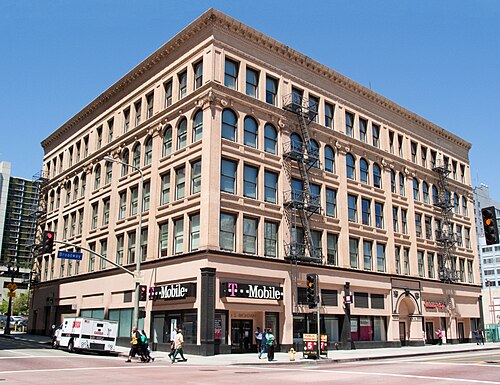 อาคารเออร์ไวน์-เบิร์น (สร้างเมื่อปี 1895)
บริเวณหัวมุมนี้เป็นที่ตั้งของอาคารที่เก่าแก่ที่สุดแห่งหนึ่งนอกเขตพลาซ่า นั่นคืออาคารเออร์ไวน์-เบิร์นหรือที่รู้จักกันในชื่อ เออร์ไวน์บล็อก หรือ เบิร์น บิลดิ้ง ซึ่งสร้างขึ้นในปี 1895 ปัจจุบันเรียกว่าแพน อเมริกัน ลอฟท์สถาปนิกคือซัมเนอร์ ฮันท์อาคารนี้สร้างขึ้นในสไตล์ผสมผสานระหว่างสเปนโคโลเนียลรีไววัลและโบซ์อาร์ต
อาคารนี้เป็นที่ตั้งของร้านขายเสื้อผ้าชื่อดังI. Magninซึ่งเปิดทำการที่นี่เมื่อวันที่ 2 มกราคม พ.ศ. 2442 [ 43 ]เมื่อวันที่ 19 มิถุนายน พ.ศ. 2447 I. Magnin ได้ประกาศว่าร้านในลอสแอนเจลิสจะรู้จักกันในชื่อMyer Siegelนับ จากนี้เป็นต้นไป [ 36 ]หลังจากเกิดเพลิงไหม้ที่อาคาร Irvine Byrne ซึ่งทำลายร้านค้าของตนเมื่อวันที่ 16 กุมภาพันธ์ พ.ศ. 2454 Myer Siegel จึงย้ายไปทางใต้บนถนนบรอดเวย์
อาคารนี้ได้รับการปรับปรุงให้ทันสมัยและดัดแปลงเป็นห้องใต้หลังคาในปี 2550 และได้รับชื่อปัจจุบัน ห้องโถงและบันไดปรากฏในภาพยนตร์และโฆษณาทางโทรทัศน์หลายเรื่อง[ 44 ]
จากถนนเธิร์ดสตรีททางใต้ไปจนถึงถนนโอลิมปิกบูเลอวาร์ด (เดิมคือถนนเทนท์สตรีท) และจากถนนฮิลล์สตรีททางตะวันออกไปจนถึงถนนลอสแอนเจลิสสตรีท รวมถึงถนนบรอดเวย์ คือ ย่าน ใจกลางเมืองประวัติศาสตร์ซึ่งเป็นย่านการค้าและความบันเทิงหลักของเมืองในช่วงครึ่งแรกของศตวรรษที่ 20
มุมตะวันออกเฉียงเหนือ
 ถนนบรอดเวย์ ฝั่งตะวันออก มองไปทางทิศใต้ ผ่านถนนสายที่ 3 ประมาณปี 1903-1904 จากซ้ายไปขวา: ศาลาว่าการเมืองปี 1888, อาคารรินด์จ์, อาคารแบรดเบอรี
 ถนนบรอดเวย์ ฝั่งตะวันออก มองไปทางทิศเหนือ ผ่านถนนสายที่ 3 ประมาณปี ค.ศ. 1888 จากซ้ายไปขวา: ศาลาว่าการเมืองปี ค.ศ. 1888, อาคารรินด์จ์, อาคารแบรดเบอรี
ที่มุมนี้: [ 45 ]
- เดิมทีบ้านหลังนี้เป็นของ เจ.ซี. เกรฟส์โดยเกรฟส์ซื้อที่ดินผืนนี้ในปี 1879 ในราคา 2,250 ดอลลาร์ ต่อมาบ้านหลังนี้ถูกขายและย้ายไปอยู่ที่ถนนสายที่ 10 และถนนโฮป ในปี 1888
- อาคาร Rindge Block (สร้างในปี 1898 ขายในปี 1899 ในราคา 190,000 ดอลลาร์ ให้กับFrederick H. Rindgeผู้ได้รับฉายาว่า "ราชาแห่งมาลิบู") ตั้งอยู่ที่ 248–260 S. Broadway เป็นอาคารพาณิชย์ ปัจจุบันชั้นบนสุดถูกรื้อออก เหลือเพียงชั้นล่างเท่านั้น
มุมตะวันตกเฉียงใต้
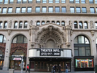 โรงละครล้านดอลลาร์
- โรงภาพยนตร์ Million Dollar Theatre (สร้างในปี 1917-1918 ออกแบบโดยสถาปนิก Albert C. Martin และ William Lee Woollettสไตล์สเปนบาโร ก มีที่นั่ง 2,345 ที่นั่ง) ตั้งอยู่ที่เลขที่ 307 (เดิมเลขที่ 301–313) ถนนบรอดเวย์ใต้ เป็นโรงภาพยนตร์ที่อยู่ทางเหนือสุดของโรงภาพยนตร์ขนาดใหญ่ใน ย่านโรงภาพยนตร์บรอดเวย์และได้รับการขึ้นทะเบียนเป็นที่ทางประวัติศาสตร์แห่งชาติ[ 46 ]สร้างโดย Sid Graumanผู้ซึ่งต่อมาได้เปิดโรงภาพยนตร์ Grauman's Chinese Theatreในฮอลลีวูดโรงภาพยนตร์แห่งนี้ได้รับการออกแบบโดยสถาปนิกที่มีด้านหน้าอาคารแปลกตาใน สไตล์ Churrigueresqueหลังจากเป็นหนึ่งในโรงภาพยนตร์ฉายรอบปฐมทัศน์ที่มีชื่อเสียงที่สุดของเมืองมานานกว่า 30 ปี โรงภาพยนตร์ Million Dollar Theatre ได้นำเสนอภาพยนตร์ภาษาสเปนและรายการวาไรตี้โชว์ตั้งแต่ปี 1950 จนถึงปลายทศวรรษ 1980 โรงภาพยนตร์แห่งนี้มีที่นั่ง 2,345 ที่นั่งเมื่อเปิดทำการในปี 1918 [ 47 ]
- ก่อนหน้านั้น ตั้งแต่ราวปี ค.ศ. 1895–1917 อาคารMuskegon Blockตั้งอยู่บนพื้นที่ดังกล่าว[ 48 ] (สร้างขึ้นราวปี ค.ศ. 1895) [ 49 ]ซึ่งตั้งชื่อตามเมือง Muskegon รัฐมิชิแกน ที่ซึ่ง Thomas Douglas Stimsonผู้พัฒนาเมืองได้สร้างฐานะร่ำรวยจากธุรกิจไม้ ตั้งแต่ปี ค.ศ. 1905–1917 ห้างสรรพสินค้า Ville de Parisตั้งอยู่ติดกันที่อาคาร Homer Laughlinและอาคาร Muskegon Block เป็นที่ตั้งของร้านค้าปลีกต่างๆ เช่น ร้านขายหมวก ร้านขายเครื่องแต่งกายบุรุษ ร้านขายเครื่องประดับ ร้านขายเปียโนและเครื่องดนตรี[ 50 ]รวมถึงสำนักงานต่างๆ ด้วย
มุมตะวันออกเฉียงใต้
 จาก Bunker Hillไปยังอาคาร Bradbury และStimson Blockปี 1894–1895
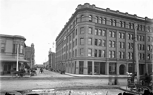 อาคารแบรดเบอรี ค.ศ. 1894
- อาคารแบรดเบอรี (ค.ศ. 1893 ออกแบบโดยสถาปนิกซัมเนอร์ ฮันต์และจอร์จ ไวแมน สไตล์ เรเนสซองส์อิตาลี โรมาเนสก์และชิคาโกสคูล ) เป็นอาคารพาณิชย์ที่เก่าแก่ที่สุดที่ยังคงเหลืออยู่ในย่านดาวน์ทาวน์ของลอสแอนเจลิสองค์กรอนุรักษ์ลอสแอนเจลิส เรียกอาคารนี้ว่าเป็นสัญลักษณ์และ "สมบัติอันล้ำค่าที่ไม่เหมือนใคร" สร้างขึ้นตามคำสั่งของ ลูอิส แบรดเบอรีมหาเศรษฐีด้านการทำเหมืองทองคำและอสังหาริมทรัพย์ อาคารนี้มีชื่อเสียงในด้านห้องโถงกลางที่สว่างไสว ลิฟต์แบบกรงเปิด บันไดหินอ่อน และราวเหล็กดัดที่ประดับประดาอย่างวิจิตร และปรากฏในภาพยนตร์หลายเรื่อง รวมถึง Blade Runner [ 47 ]
ถนนสปริง
แกลเลอรี่
 ภาพถ่ายมองไปทางทิศตะวันออกเฉียงเหนือบนถนนสปริง จากถนนเฟิร์สต์ ในช่วงทศวรรษ 1880 ร้าน Peoples Store ของAsher Hamburger อยู่ตรงกลาง อาคารสูงของ Baker Blockมองเห็นได้ในระยะไกล
 ภาพถ่ายมองไปทางทิศตะวันออกเฉียงเหนือของถนนสปริง จากถนนเฟิร์สต์ ในช่วงทศวรรษ 1890 ร้านแฮมเบอร์เกอร์ พีเพิลส์ สโตร์ ซึ่งปัจจุบันอยู่ในอาคารฟิลลิปส์อยู่ตรงกลางภาพ รถรางไฟฟ้าเข้ามาแทนที่รถม้า และถนนก็ปูด้วยแอสฟัลต์ ปัจจุบัน ที่นี่เป็นที่ตั้งของศาลากลางเมือง
 ภาพถ่ายมองไปทางทิศใต้ของถนนสปริงจากอาคารเทมเปิล ประมาณปี 1883–1894 หอคอยในฉากหลังคืออาคารฟิลลิปส์บล็อกอาคารขนาดใหญ่สองหลังทางด้านขวาคืออาคารโจนส์บล็อกและอาคารซิตี้ออฟปารีส (มีหอคอยเล็กๆ) ทางด้านขวาสุดคืออาคารอัลเลนบล็อกและ บริษัทเสื้อผ้าลอนดอนของ แฮร์ริสและแฟรงค์พร้อมนาฬิกาที่เป็นแลนด์มาร์ค
ฝั่งตะวันตกของสปริง ทางใต้ของเทมเปิล
 อาคารธนาคารออมทรัพย์และแลกเปลี่ยนเงินตราต่างประเทศ (ค.ศ. 1907) มุมตะวันตกเฉียงใต้ของถนนเทมเปิล/สปริง
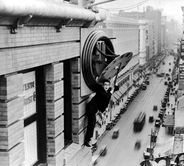 แบบจำลองด้านหน้าอาคารออมทรัพย์ระหว่างประเทศที่ปรากฏในภาพยนตร์เรื่องSafety Last!
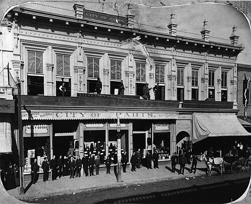 ห้างสรรพสินค้า ซิตี้ออฟปารีสตั้งอยู่ทางเหนือของถนนฟิลลิปส์บล็อกและทางใต้ของถนนเทมเปิล ในช่วงระหว่างปี 1883-1890 โปรดสังเกตเคเบิลคาร์ที่ให้บริการระหว่างปี 1885-1902
 อาคารโจนส์ เลขที่ 171–201 ถนนนอร์ทสปริง ฝั่งตะวันตก ตรงข้ามถนนมาร์เก็ต อาคารทางใต้ สร้างขึ้นประมาณปี 1880-1885
 อาคารโจนส์บล็อกในช่วงระหว่างปี 1886-1895 เคยเป็นที่ตั้งของร้านขายสินค้าแห้งบอสตันของ เจ.ดับบลิว. โรบินสัน
บริเวณด้านตะวันตกของถนนสปริงเคยมีอาคารดังต่อไปนี้ ถนนสปริงได้รับการปรับแนวใหม่ในช่วงทศวรรษ 1920 และปัจจุบันทอดตัวไปทางทิศตะวันตกของที่ตั้งอาคารเหล่านี้ และที่ตั้งของอาคารเหล่านี้ในอดีต ปัจจุบันเป็นส่วนหนึ่งของบล็อกเมืองทั้งหมดที่ศาลาว่าการเมืองตั้งอยู่:
- ที่มุมตะวันตกเฉียงใต้ของถนนสปริงและถนนเทมเปิลคืออาคารอัลเลนซึ่งระหว่างปี 1883 ถึง 1894 เป็นที่ตั้งของบริษัทเสื้อผ้าลอนดอนของแฮร์ริสและแฟรงค์ พร้อมด้วยนาฬิกาที่เป็นแลนด์มาร์ค ร้านขาย สินค้าแห้งบอสตันแห่งแรกของเจดับบลิว โรบินสันก็ตั้งอยู่ในบล็อกนี้เช่นกันตั้งแต่ปี 1883 ถึง 1886 ก่อนที่จะย้ายไปยังบล็อกโจนส์ทางทิศใต้เล็กน้อย[ 51 ]อาคารอัลเลนถูกแทนที่ด้วยอาคารธนาคารออมทรัพย์และแลกเปลี่ยนระหว่างประเทศ (10 ชั้น ปี 1907 ออกแบบโดยเอช. อัลบัน รีฟส์ สไตล์เรเนสซองส์และอิตาเลียน ถูกรื้อถอนในปี 1954-1955) [ 52 ]ซึ่งตั้งอยู่ที่มุมตะวันตกเฉียงใต้ของถนนเทมเปิลและถนนสปริง แบบจำลองของด้านหน้าอาคารปรากฏในภาพยนตร์เรื่องSafety Last! ของ แฮโรลด์ลอยด์ ในฉากที่มีชื่อเสียงซึ่งลอยด์ห้อยตัวอยู่บนนาฬิกาใกล้กับหลังคาอาคาร ในช่วงหลังๆ อาคารนี้เป็นที่ตั้งของสำนักงานสาธารณสุขของเมืองและถูกเรียกว่า "อาคารสาธารณสุขเมืองเก่า" [ 52 ]
- ห้างสรรพสินค้า ซิตี้ออฟปารีสตั้งอยู่ที่ 203–7 ถนนนอร์ทสปริง ฝั่งตะวันตก ระหว่างถนนเทมเปิลและถนนฟิลลิปส์ ปัจจุบันถนนสปริงอยู่ทางทิศตะวันตกของพื้นที่นี้ ซึ่งเป็นส่วนหนึ่งของศาลาว่าการนครปารีส
- บล็อกโจนส์
- สร้างขึ้นใน ปีพ.ศ. 2425 หรือ พ.ศ. 2426 [ 53 ]และได้รับมอบหมายจากDoria Deighton-Jones [ 54 ]ถูกรื้อถอนในช่วงปี พ.ศ. 2463 เพื่อสร้างอาคารศาลากลาง
- หมายเลขหลังปี พ.ศ. 2433 คือ 171–179 และ 201 ถนนนอร์ทสปริง[ 55 ]
- ผู้เช่าประกอบด้วย:
- สำนักงาน Los Angeles Heraldและโรงพิมพ์ไอน้ำจนถึงปี พ.ศ. 2431 [ 56 ]
- ร้าน JW Robinson's Boston Dry Goods ที่หมายเลข 171–173 เปิดให้บริการตั้งแต่ปี 1886 ถึง 1895 ต่อมา Robinson's ได้กลายเป็นห้างสรรพสินค้าขนาดใหญ่ระดับภูมิภาค
- ห้างสรรพสินค้า ซิตี้ออฟปารีสที่หมายเลข 177 ในช่วงไม่กี่ปีสุดท้ายของการดำเนินงาน ประมาณปี 1895–1897 [ 57 ]
ฟิลลิปส์ บล็อก
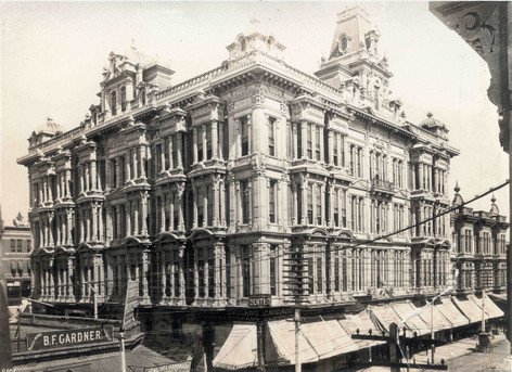
 ทางเข้า ห้างสรรพสินค้า แฮมเบอร์เกอร์ (ซึ่งเป็นต้นกำเนิดของบริษัทเมย์ โค. แคลิฟอร์เนีย ) ตั้งอยู่ที่ฟิลลิปส์ บล็อกระหว่างปี 1888-1908
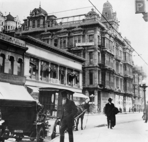 ฟิลลิปส์ บล็อกประมาณปี 1900
- ภาพถ่ายจาก ถนนเฟิร์สต์สตรีท มองไปทางทิศเหนือบนถนนสปริงสตรีท ในช่วงทศวรรษ 1890 แสดงให้เห็นอาคาร ฟิลลิป ส์บล็อก
 มองไปทางทิศเหนือบนถนนสปริงจากถนนเฟิร์สสตรีท จะเห็นอาคารฟิลลิปส์บล็อกอยู่ด้านหลัง และ บริษัทเสื้อผ้าลอนดอนของ แฮร์ริส แอนด์ แฟรงค์อยู่ที่มุมตะวันตกเฉียงใต้ของถนนแฟรงคลินและถนนสปริง
บริเวณมุมตะวันตกเฉียงเหนือของถนนแฟรงคลินและถนนสปริง เคยมีอาคารสองหลังตั้งอยู่ติดกัน คือ บ้านดินโรชา และอาคารฟิลลิปส์ ปัจจุบันพื้นที่ดังกล่าวอยู่ใต้แนวถนนสปริงในปัจจุบัน ซึ่งถูกปรับให้ตรงขึ้น หรือก็คือปรับแนวให้วิ่งไปทางทิศตะวันตกมากขึ้น ในช่วงทศวรรษ 1920
- บ้านดินโรชา (สร้างขึ้นในปี พ.ศ. 2363 เป็นที่อยู่อาศัยของอันตูส โฮเซ โรชา) เลขที่ 31–33 ถนนสปริง (หมายเลขก่อนปี พ.ศ. 2333) ซึ่งตั้งแต่ปี พ.ศ. 2396 ถึง พ.ศ. 2327 ทำหน้าที่เป็นศาลากลางเมือง และอาคารในลานด้านหลังทำหน้าที่เป็นเรือนจำของเมืองและเทศมณฑล[ 58 ]ต่อมาได้มีการรื้อถอนและสร้างอาคารใหม่ขึ้นแทนที่
- อาคารฟิลลิปส์บล็อก (สูงสี่ชั้นครึ่ง เปิดใช้งานในปี 1888 ออกแบบโดยเบอร์เจส เจ. รีฟสถาปัตยกรรมแบบฟื้นฟูศิลปะเรเนส ซองส์ ฝรั่งเศส) ตั้งอยู่ที่ 25–37 ถนนนอร์ทสปริง (หมายเลขอาคารก่อนปี 1890) บริเวณมุมตะวันตกเฉียงเหนือของถนนแฟรงคลิน ติดกับถนนนิวไฮสตรีททางด้านตะวันตก อาคารนี้เป็นของ หลุยส์ ฟิลลิปส์ เจ้าของ ฟาร์มปศุสัตว์ในหุบเขาโพโมนามีราคา 260,000 ดอลลาร์ มีหน้ากว้างติดถนนสปริง 120 ฟุต (37 เมตร) ติดถนนแฟรงคลิน 218 ฟุต (66 เมตร) และติดถนนนิวไฮสตรีท 121 ฟุต (37 เมตร) อาคารนี้เป็นอาคารสี่ชั้นหลังที่สองในลอสแอนเจลิส บางครั้งเรียกว่าฟิลลิปส์บล็อกหมายเลข 1 (มี "ฟิลลิปส์บล็อกหมายเลข 2" ที่ 135–145 ถนนลอสแอนเจลิส ทางด้านตะวันตก ระหว่างถนนมาร์เก็ตและถนนเฟิร์สต์) [ 59 ]ในเดือนกรกฎาคม พ.ศ. 2431 แอชเชอร์ แฮมเบอร์เกอร์เปิดร้าน Peoples Storeที่นี่ ซึ่งต่อมาเป็นที่รู้จักในชื่อHamburger'sและกลายเป็นร้านค้าปลีกที่ใหญ่ที่สุดในภาคตะวันตกของสหรัฐอเมริกา ในปี พ.ศ. 2451 ร้านได้ย้ายไปอยู่ที่ถนนสายที่ 8 และบรอดเวย์ และในปี พ.ศ. 2466 แฮมเบอร์เกอร์ได้ขายกิจการให้กับ May Co. และกลายเป็นMay Company California [ 60 ] อาคาร Phillips Block ถูกรื้อถอนในช่วงกลางทศวรรษ พ.ศ. 2463 เพื่อเปิดทางให้กับถนน Spring Street ที่ปรับแนวใหม่และศาลากลางเมืองในปัจจุบัน
แฟรงคลินถึงเฟิร์ส
ในช่วงปี พ.ศ. 2437-2448 ที่มุมตะวันตกเฉียงใต้ของถนนแฟรงคลิน มีร้านเสื้อผ้าลอนดอนของแฮร์ริส แอนด์ แฟรงค์พร้อมนาฬิกาอันเป็นสัญลักษณ์[ 61 ] [ 62 ]แฮร์ริส แอนด์ แฟรงค์ ได้กลายเป็นเครือข่ายห้างสรรพสินค้าขนาดเล็กสำหรับเสื้อผ้าบุรุษทั่วภูมิภาค
ฝั่งตะวันออกของสปริง ทางใต้ของเทมเปิล
บล็อกวัด
 ภาพถ่ายมองไปทางทิศใต้บนถนนเมนสตรีท มุ่งหน้าไปยังเทมเปิลบล็อก ซึ่งมีร้านขายสินค้าแห้งของอดอล์ฟ โปรตุเกส ตั้งอยู่ ในช่วงกลางทศวรรษ 1870
 มองไปทางทิศใต้ไปยัง Temple Block บนถนน Main St. ทางเหนือขึ้นไปอีกเล็กน้อย ในช่วงกลางทศวรรษ 1870
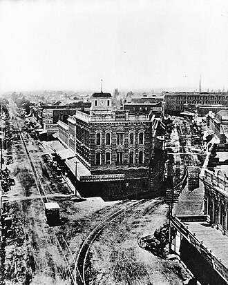 อาคาร Temple Block ประมาณปี ค.ศ. 1885 หอนาฬิกาของศาลปรากฏให้เห็นอยู่ด้านหลังอาคาร Temple Block ทันที ถนน Main St. (ซ้าย) ถนน Spring St. (ขวา)
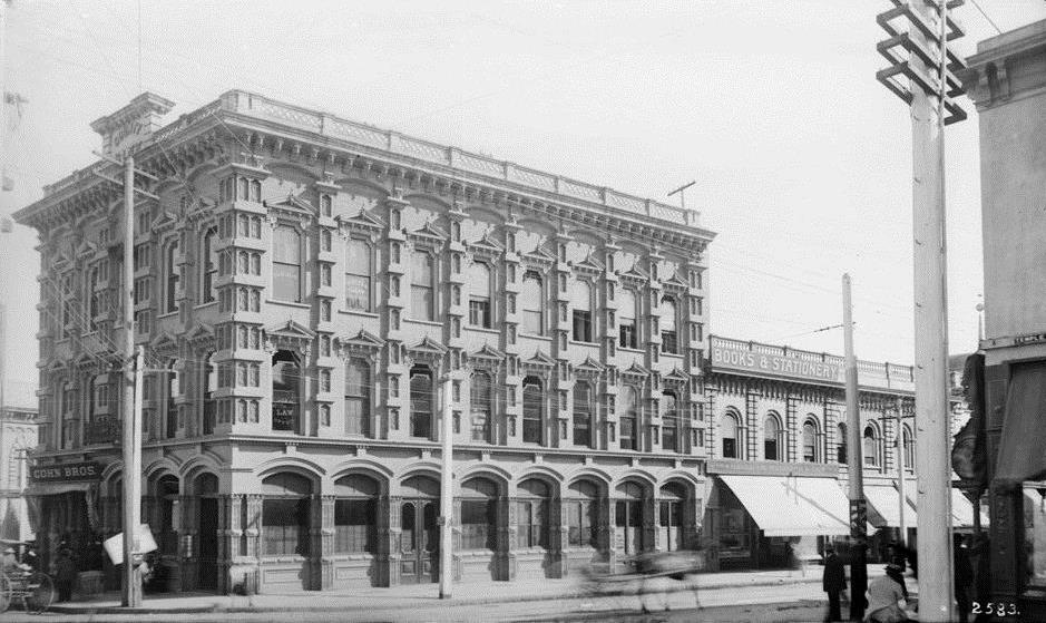 ป้ายร้าน Cohn Bros. ฝั่งถนน Spring St. บริเวณ Temple Block ช่วงกลางทศวรรษ 1890
 ส่วนตะวันออกเฉียงเหนือของ Temple Block บริเวณมุมตะวันตกเฉียงใต้ของ Temple (ขวา) และ Main (ซ้าย) ปี 1924
 ด้านตะวันออกของ Temple Block มองไปทางทิศเหนือตามแนวฝั่งตะวันตกของถนน Main Street ไปยัง Temple St. (ขวา) ปี 1924
พื้นที่รูปสามเหลี่ยมตรงจุดที่ถนนสปริงและถนนเมนมาบรรจบกันทางด้านใต้ของถนนเทมเปิล คือที่ตั้งของเทมเปิลบล็อกซึ่งแท้จริงแล้วเป็นกลุ่มอาคารหลายหลังที่ตั้งอยู่บนพื้นที่ซึ่งล้อมรอบด้วยถนนสปริง ถนนเมน และถนนเทมเปิล เทมเปิลบล็อกหลังแรกหรือเทมเปิลบล็อกเก่าสร้างโดยฟรานซิสโก (เอฟพีเอฟ) เทมเปิล ในปี 1856 เป็นอาคารดินเหนียวสองชั้น หันหน้าไปทางทิศเหนือสู่ถนนเทมเปิล ต่อมาได้รวมเข้ากับเทมเปิลบล็อกที่ขยายใหญ่ขึ้นในภายหลังในปี 1871 แล้วจึงถูกรื้อถอน จอร์จ พี. แมคเลน เขียนไว้ว่าเมื่อเขามาถึงเมืองนี้ในปี 1868 เทมเปิลบล็อกเป็นศูนย์กลางการค้าและชีวิตทางสังคมที่ไม่มีใครโต้แย้งได้ในเมือง แม้กระทั่งในช่วงต้นทศวรรษ 1880 ก็ยังถือว่าเป็นอาคารที่สง่างามที่สุดของเมือง เป็นที่ตั้งของสำนักงานกฎหมายหลายแห่ง รวมถึงของสตีเฟน เอ็ม. ไวท์วิล ดี. กูลด์ และกลาส เซลล์ แชปแมน แอนด์สมิธ[ 63 ]บล็อกนี้มีบทบาทสำคัญในประวัติศาสตร์การค้าปลีกของลอสแอนเจลิสเนื่องจากเป็นที่ตั้งแห่งแรกของร้านค้าปลีกระดับไฮเอนด์หลายแห่งที่จะกลายเป็นชื่อดังในเมือง ได้แก่Desmond's (1870–1882) [ 64 ]และJacoby Bros. (1879–1891) [ 65 ]นอกจากนี้ยังเป็นที่ตั้งของOdd Fellows , Fashion Saloon, Temple and Workman Bank, ร้านขายปืน Slotterbeck's และ สำนักงาน Wells Fargoมุมตะวันออกเฉียงเหนือเป็นที่ตั้งของร้านขายสินค้าแห้งของ Adolph Portugal (1874-1879?), Jacoby Bros. (1879–1891) และCohn Bros. (1892–1897) ตามลำดับ[ 66 ] [ 67 ]
ในช่วงปี ค.ศ. 1925-1927 บริเวณนี้และพื้นที่โดยรอบอื่นๆ ถูกรื้อถอนเพื่อสร้างศาลาว่าการเมืองลอสแอนเจลิส ใน ปัจจุบัน
ทางด้านทิศใต้ของ Temple Block คือถนน Market Streetซึ่งเป็นถนนเล็กๆ ที่ทอดยาวระหว่างถนน Spring และถนน Main
ศาลหอนาฬิกา/อาคารบูลลาร์ด
 ศาลากลางหอนาฬิกา มองจากเนินป้อม (จากทางทิศตะวันตก)
 ภาพจากถนนสปริง มองเห็นศาลากลางเมืองคล็อกทาวเวอร์ (ขวา), ด้านทิศใต้ของเทมเปิลบล็อก (ซ้าย), โรงแรมยูไนเต็ดสเตทส์ (ด้านหลัง)
 หอนาฬิกา (วัด) ศาล ตลาด และโรงละคร
 ศาลากลางจังหวัดคล็อกทาวเวอร์ มองจากถนนสปริงไปทางทิศตะวันออกเฉียงใต้ โดย เห็น ร้าน Vienna Buffetบนถนนคอร์ทสตรีท
 ศาลหอนาฬิกา
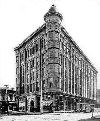 อาคารบูลลาร์ดบล็อก สร้างขึ้นราวปี ค.ศ. 1900 แทนที่ศาลคล็อกทาวเวอร์ในปี ค.ศ. 1895
บนพื้นที่บล็อกเล็กๆ ทางทิศใต้ของ Temple Block ระหว่างถนน Market และ Court ซึ่งหันหน้าเข้าหาทั้งถนน Spring และถนน Main มีอาคารสองหลังตั้งเรียงกัน:
- อาคารศาลหอนาฬิกา : ตั้งอยู่ทางใต้ของ Temple Block ข้ามถนน Market Street เล็กๆ เป็นอาคารที่มีชื่อเรียกหลายชื่อ เช่นTemple Courthouse , Temple Market, Temple Theater, Old County Courthouse เป็นต้น อาคารนี้สร้างโดย John Temple ในปี 1858 เดิมทีเป็นตลาด (ชั้นล่าง) และโรงละคร (ชั้นบน) ถูกรื้อถอนในช่วงปี 1890 [ 68 ] [ 69 ]ใช้เป็นตลาดและร้านค้าปลีก รวมทั้งเป็นศาลประจำเทศมณฑลตั้งแต่ปี 1861-1891 จนกระทั่งศาล Red Sand Courthouse สร้างเสร็จ[ 70 ]มีหอคอยทรงสี่เหลี่ยมผืนผ้าอยู่ด้านบน มีนาฬิกาอยู่ทั้งสี่ด้าน[ 71 ] [ 72 ]อาคารศาลหอนาฬิกาถูกรื้อถอนในปี 1895 และถูกแทนที่ด้วย:
- อาคาร Bullard Blockสร้างขึ้นในปี 1895-1896 โดยสถาปนิกMorgan & Walls [ 73 ] ตั้งอยู่ที่ 154–160 N. Spring มุมตะวันออกเฉียงเหนือของถนน Court Street แทนที่ Clocktower Courthouse เคยเป็นที่ตั้งของThe Hub Clothing Co. ซึ่งเป็นห้างสรรพสินค้าขนาดใหญ่สำหรับเสื้อผ้า ดูภาพ "La Fiesta" ด้านล่างด้วย ถูกรื้อถอนในปี 1925-1926 เพื่อสร้าง ศาลาว่าการเมืองลอส แอนเจลิส ในปัจจุบัน [ 74 ]
ศาลทางใต้ไปยังแห่งแรก
 ร้าน Vienna Buffetซึ่งมีบทบาทสำคัญในประวัติศาสตร์ของกลุ่ม LGBTQ ในเมืองเวียนนา ภาพถ่ายนี้ถ่ายในช่วงระหว่างปี 1891-1902
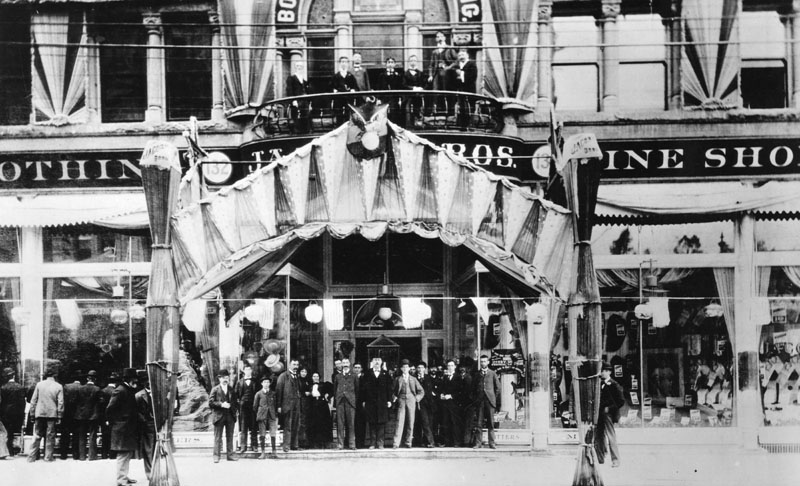 ร้าน Jacoby Bros.ที่โอ่อ่าหรูหราตั้งอยู่ที่ 128–134 ถนน N. Spring Street ประมาณปี 1896
- ถนนคอร์ทสตรีทเป็นถนนเล็กๆ ที่ทอดยาวระหว่างถนนสปริงและถนนเมน ที่เลขที่ 12-14-16 ถนนคอร์ทสตรีท (การกำหนดหมายเลขก่อนปี 1890) เลขที่ 112–116 ถนนคอร์ทสตรีท (การกำหนดหมายเลขหลังปี 1890) คือโรงละครทิโวลีซึ่งเปิดและปิดในปี 1890 ตั้งแต่ปี 1891 ถึงปี 1902 สถานที่แห่งนี้คือ ร้านอาหาร เวียนนาบุฟเฟต์ (ใหม่) ซึ่งมีดนตรีสด และเป็นที่ที่เกิดเรื่องอื้อฉาวและการรวมตัวของชายรักร่วมเพศ รวมถึงสิ่งที่ในสมัยนั้นเรียกว่า "she boys" [ 75 ]จากนั้นตั้งแต่ปี 1902 ถึงประมาณปี 1910 สถานที่แห่งนี้คือโรงละครซิ นี โอกราฟ ซึ่งเป็นสถานที่จัดแสดงวอเดวิลล์ ตั้งแต่ปี 1918 ถึงปี 1925 สถานที่แห่งนี้ถูกทำเครื่องหมายว่าเป็นโรงละครจีนโดยมีบริษัทซุนจุงหวาทำการแสดงละครจีน[ 76 ]
- ร้านขายของชำ H. Jevne & Co.ตั้งอยู่ที่เลขที่ 38–40 (หลังปี 1890: 136-138) ถนน N. Spring (อาคาร "Wilcox Block" เดิม หรือที่รู้จักกันในชื่อ Strelitz Block) ตั้งแต่ปี 1890-1896 ก่อนที่จะย้ายไปยังอาคาร Wilcoxเมื่อเปิดทำการที่ถนน 2nd และ Spring [ 77 ] [ 78 ]
- ร้านขายสินค้าแห้ง Jacoby Bros.ตั้งอยู่ที่ 128–134 N. Spring St. ตั้งแต่ปี 1891-1900 และได้เพิ่มพื้นที่ของ Jevne ในปี 1896 (จึงครอบคลุมพื้นที่ทั้งหมดตั้งแต่ 128 ถึง 138 N. Spring) ร้านค้าย้ายไปที่ Broadway ทางใต้ของถนนสายที่ 3 ในปี 1900 [ 79 ] [ 80 ]ซึ่งเป็นสัญญาณอีกอย่างหนึ่งว่าย่านช้อปปิ้งระดับไฮเอนด์กำลังเคลื่อนตัวไปทางทิศตะวันตกเฉียงใต้ห่างจากบริเวณนี้ในเวลานั้น
แรกและฤดูใบไม้ผลิ

 มองไปทางทิศเหนือบนถนนสปริงจากถนนเฟิร์สต์ อาคารธนาคารแห่งชาติลอสแอนเจลิสอยู่ด้านหน้าทางขวา อาคารลาร์รอนด์อยู่ด้านหน้าทางซ้าย อาคารฟิลลิปส์ปรากฏให้เห็นในฉากหลัง สังเกตรถรางไฟฟ้าที่วิ่งไปยังถนนแกรนด์อเวนิว
ภาพด้านบนซ้ายมองไปทางทิศใต้ผ่านจุดตัดระหว่างถนนเฟิร์สและถนนสปริง ในช่วงประมาณปี 1900-1906 ยอดแหลมของอาคารวิลสันบล็อกโดดเด่นอยู่ทางด้านซ้าย เช่นเดียวกับโรงแรมนาเดาทางด้านขวา ด้านหน้าเราจะเห็นธนาคารแห่งชาติลอสแอนเจลิสทางด้านซ้ายและอาคารลาร์รอนด์บล็อกทางด้านขวา จากถนนเฟิร์สถึงถนนเซคันด์ ถนนสปริงยังคงเป็นย่านช้อปปิ้งที่คึกคัก แม้ว่าถนนบรอดเวย์กำลังเริ่มเป็นที่นิยมสำหรับการช้อปปิ้งระดับไฮเอนด์มากขึ้น รถรางไฟฟ้ามุ่งหน้าไปยังถนนกริฟฟินในมอนเตซิโตไฮท์ซึ่งต่อมาจะกลายเป็นสาย 2ของทางรถไฟล อสแอนเจลิส ปัจจุบัน มุมมองนี้จะเป็นสำนักงานใหญ่ของ กรมตำรวจลอสแอนเจลิส (LAPD)ในปี 2009 ซึ่งกินพื้นที่ทั้งบล็อกทางด้านซ้าย และทางด้านขวาคืออาคารลอสแอนเจลิสไทมส์ในปี 1935 และด้านหลังคืออาคารครอว์ฟอร์ดมิเรอร์แอดดิชั่นในปี 1948
มุมตะวันตกเฉียงเหนือของถนนเฟิร์สและถนนสปริง
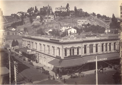
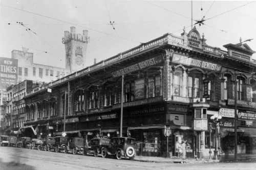 ภาพถ่ายอาคารลาร์รอนด์ บล็อก ไม่ระบุวันที่ น่าจะเป็นช่วงทศวรรษ 1910
 มุมตะวันตกเฉียงเหนือของถนน 1st/Spring ปี 2020 ที่ดินว่างเปล่า ด้านหลังขวา: ศาลประจำเทศมณฑล (ปี 1972)
- อาคารลาร์รอนด์สร้างขึ้นในปี พ.ศ. 2425 ด้วยงบประมาณ 10,000 ดอลลาร์[ 82 ]เลขที่ 211 ถนนเวสต์ 1 และเลขที่ 101–105 ถนนนอร์ทสปริง อาคารสองชั้น[ 81 ]สำนักงานและร้านค้าปลีก รวมถึง:
- Mullen & Bluettร้านขายเสื้อผ้าขนาดใหญ่ 101–105 N. Spring [ 83 ]ตั้งแต่ก่อตั้งในปี พ.ศ. 2432 จนถึงปี พ.ศ. 2453 [ 84 ]
- อาคารรัฐแคลิฟอร์เนีย (สร้างเสร็จในปี 1931 เปิดในปี 1932 ออกแบบโดยสถาปนิกJohn C. Austinในปี 1931 รื้อถอนในปี 1976) [ 85 ]
- ที่ดินแปลงนี้ว่างเปล่าในขณะนี้
มุมตะวันออกเฉียงเหนือของถนนเฟิร์สและถนนสปริง
 ภาพถ่ายด้านตะวันออกของถนนสปริง ทางเหนือของถนนเฟิร์สท์ ในช่วงเทศกาลฟิเอสต้า เดอ ลอสแองเจลิสปี 1903 อาคารบูลลาร์ดอยู่ไกลออกไปทางด้านบน ตรงกลางด้านซ้าย
 อาคารธนาคารแห่งชาติลอสแอนเจลิส
 อาคารธนาคารออมทรัพย์ยุติธรรม
 ด้านทิศเหนือของถนนเฟิร์สสตรีท ระหว่างถนนสปริงและถนนเมน อาคารวิทนีย์ ประมาณปี 1888
- อาคารธนาคารแห่งชาติลอสแอนเจลิส (ค.ศ. 1887-1906) ถูกรื้อถอนและสร้างใหม่เป็นอาคารหลังใหม่
- อาคาร Equitable (ธนาคารออมทรัพย์ Equitable, 1906-1920s) [ 86 ]
ถนนสายแรกจากสปริงถึงเมน
ถนนเฟิร์สต์สตรีทฝั่งตะวันออกของสปริง: อาคารวิทนีย์ (หรือ อาคาร โจเซฟ วิทนีย์ ) สร้างขึ้นในปี 1883 ตั้งอยู่ทางด้านเหนือ ร้านหนังสือหลักของออลมสเตด แอนด์ เวลส์ตั้งอยู่ในอาคารนี้ในช่วงกลางทศวรรษ 1880
มุมตะวันตกเฉียงใต้ของถนนเฟิร์สและถนนสปริง
 อาคารนาเดา ซึ่งเป็นที่ตั้งของโรงแรมนาเดา (ค.ศ. 1882–1932)
 อาคาร LA Times เปิดใช้งานในปี 1935 ภาพถ่ายปี 2006
- อาคาร Nadeau Block หรือโรงแรม Nadeauสร้างขึ้นในปี 1881-1882 และถูกรื้อถอนในปี 1932 ออกแบบโดยสถาปนิกKysor & Morganตั้งอยู่มุมตะวันตกเฉียงใต้ของถนน Spring และถนน First เป็นอาคารสี่ชั้นหลังแรกในเมือง[ 87 ]
- บริเวณหัวมุมนี้ปัจจุบันเป็นที่ตั้งของอาคารลอสแอนเจลิสไทมส์ซึ่งเปิดทำการในปี 1935 เป็นส่วนหนึ่งของ กลุ่มอาคาร ไทม์ส มิเรอร์ สแควร์ที่กินพื้นที่ทั้งบล็อกระหว่างถนนสปริง ถนนบรอดเวย์ ถนนเฟิร์สต์ และถนนเซคันด์ ซึ่งเดิมเป็นสำนักงานใหญ่ของหนังสือพิมพ์ลอสแอนเจลิสไทมส์ปัจจุบันว่างเปล่า
มุมตะวันออกเฉียงใต้ของถนนเฟิร์สและถนนสปริง
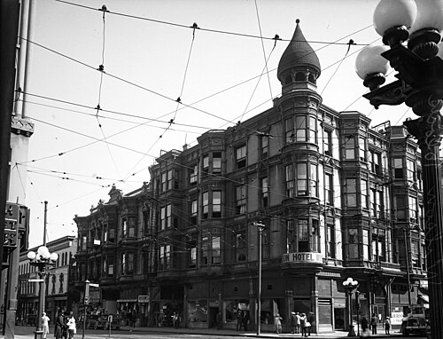 วิลสัน บล็อก ในปี 1920
 อาคารพาณิชย์สองชั้นที่สร้างขึ้นราวปี 1927 ซึ่งมีสาขาของธนาคารซีเคียวริตี้ แปซิฟิก ตั้งอยู่ มองเห็นได้จากหอคอยศาลากลาง
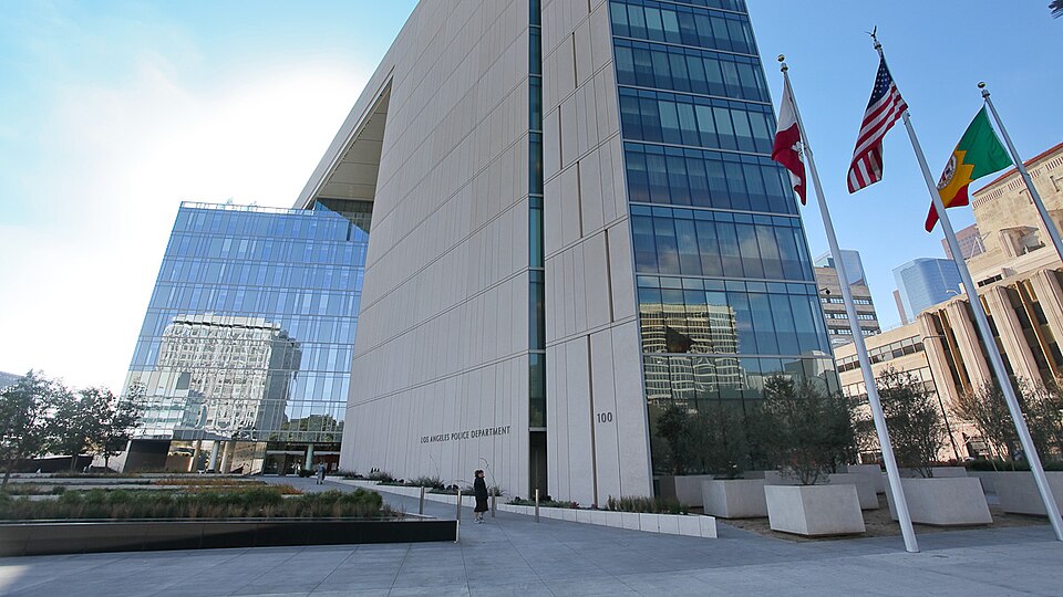 อาคารสำนักงานใหญ่ LAPD ปี 2009
มีอาคารสี่หลังตั้งอยู่ ณ ที่แห่งนี้เรียงต่อกัน:
- บ้านของจอร์จ เอส. วิลสัน[ 88 ]
- อาคารวิลสันบล็อกบางครั้งเรียกว่าตึกระฟ้าแห่งแรกของเมือง[ 89 ]สร้างขึ้นระหว่างปี 1886-1888 และถูกรื้อถอนประมาณปี 1927 [ 90 ]ปัจจุบันมุมนี้เป็นที่ตั้งของ อาคารสำนักงานใหญ่ กรมตำรวจลอสแอนเจลิสซึ่งสร้างเสร็จในปี 2009 [ 91 ]ปัจจุบันสถานที่แห่งนี้เป็นที่ตั้งของ:
- อาคารค้าปลีกสองชั้นที่สร้างขึ้นใหม่[ 89 ]ซึ่งเป็นที่ตั้งของสาขา "Equitable" ของธนาคาร Security Pacific National Bankซึ่งในขณะนั้นคือธนาคาร Security Trust and Savings Bank ( อาคาร Equitableอยู่ฝั่งตรงข้ามถนนทางทิศเหนือ) [ 92 ]
- ตั้งแต่ปี 2009 อาคารสำนักงานใหญ่ตำรวจได้กินพื้นที่ทั้งบล็อกระหว่างถนนเฟิร์ส ถนนเซคันด์ ถนนสปริง และถนนเมน
ครั้งที่สองและฤดูใบไม้ผลิ
มุมตะวันตกเฉียงเหนือของถนนเซคันด์และถนนสปริง
 อาคารไบรสัน หรือ ไบรสัน-โบนเบรก สร้างขึ้นระหว่างปี 1886-1888 ภาพถ่ายปี 1905
 อาคาร "Crawford Addition" ปี 1948 บริเวณไทม์ส มิเรอร์ สแควร์ มุมตะวันตกเฉียงเหนือของถนนสายที่ 2 และถนนสปริง เดือนกันยายน 2020
- อาคารไบรสันหรือที่รู้จักกันในชื่ออาคารไบรสัน-โบนเบรก หรืออาคารไบรสัน โบนเบรก ตั้งอยู่มุมตะวันตกเฉียงเหนือของถนนสายที่ 2 และถนนสปริง สร้างขึ้นระหว่างปี 1886-1888 ด้วยงบประมาณ 224,000 ดอลลาร์ บนพื้นที่ซึ่งเคยเป็นโรงเรียนของรัฐและศาลากลางเมืองในยุคแรก โดยเป็นอาคารธนาคารและสำนักงานขนาด 126 ห้องสถาปัตยกรรมแบบโรมาเนสก์มีการต่อเติมเพิ่มอีกสองชั้นระหว่างปี 1902-1904 และถูกรื้อถอนในปี 1934 สถาปนิกคือ โจเซฟ แคเธอร์ นิวซัม ( นิวซัม แอนด์ นิวซัม ) ฐานข้อมูลสถาปัตยกรรมชายฝั่งแปซิฟิกกล่าวว่าอาคารนี้ "น่าทึ่งอย่างยิ่ง แสดงให้เห็นถึงการผสมผสานที่หลากหลายและแปลกใหม่" สร้างขึ้นสำหรับนายกเทศมนตรีจอห์น ไบรสันและพันตรีจอร์จ เอช. โบนเบรก ประธานธนาคารแห่งชาติลอสแอนเจลิสและบริษัทสินเชื่อและทรัสต์แห่งรัฐ[ 93 ]ห้างสรรพสินค้าเดสมอนด์ตั้งอยู่ที่นี่ตั้งแต่ปี 1890 ถึง 1900 [ 64 ]
อาคารหลังนั้นถูกแทนที่ด้วย อาคาร Crawford Addition ที่สร้างขึ้น ในปี 1948 ซึ่งเป็นส่วนหนึ่งของ กลุ่มอาคาร Times Mirror Squareและปัจจุบันว่างเปล่า
มุมตะวันออกเฉียงเหนือของถนนเซคันด์และถนนสปริง
 ภาพถ่ายปี 1902 ของอาคาร Burdick Block ซึ่งตั้งอยู่มุมตะวันออกเฉียงเหนือของถนน 2nd และ Spring สร้างขึ้นในปี 1888 และต่อเติมชั้นบนในปี 1900
 สำนักงานใหญ่ LAPDเปิดทำการในปี 2012 ตั้งอยู่มุมตะวันออกเฉียงเหนือของถนนสายที่ 2 และถนนสปริง
- อาคาร Burdick Blockหรือที่รู้จักกันในชื่อTrust Buildingเลขที่ 127 W. 2nd St. สร้างขึ้นในปี 1888 ( JN Preston & Son ) ชั้นบนสุดถูกต่อเติมในปี 1900 ( John Parkinson ) ในปี 1910 ได้มีการปรับปรุงใหม่และเปลี่ยนชื่อเป็นAmerican Bank Buildingปัจจุบันเป็นที่ตั้งของสำนักงานใหญ่กรมตำรวจลอสแอนเจลิส ซึ่งครอบคลุมพื้นที่ทั้งบล็อกตั้งแต่ First ถึง Second และจาก Spring ถึง Main สร้างเสร็จในปี 2009 [ 94 ] [ 95 ]
มุมตะวันตกเฉียงใต้ของถนนเซคันด์และถนนสปริง
 มองไปทางทิศตะวันตกบนถนนสายที่ 2 บริเวณแยกสปริง อาคารฮอลเลนเบ็ค (ซ้าย) เมื่อครั้งยังมีเพียงสองชั้น สังเกตร้านของคูลเตอร์ ; ศาลากลางเมืองหลังที่ 2 (ขวา) ปี 1886
 ภาพถ่ายมองไปทางทิศใต้บนถนนสปริงตัดกับถนนสายที่ 2 บริเวณอาคารฮอลเลนเบ็คบล็อก ซึ่งเคยเป็นอาคารสองชั้น และร้านค้าของคูลเตอร์ ในปี 1886
 อาคาร Hollenbeck Block (ค.ศ. 1884-1933) มุมตะวันตกเฉียงใต้ของถนน 2nd และ Spring ประมาณปี ค.ศ. 1900-1905
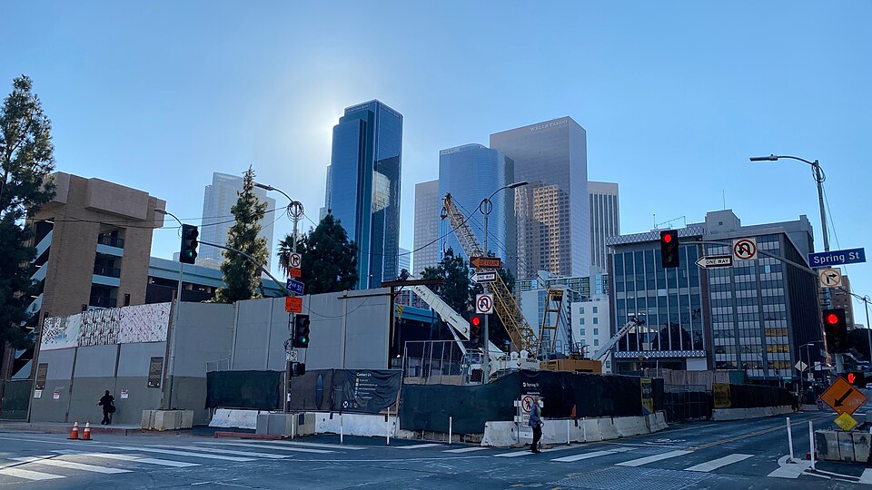 สถานีบรอดเวย์อันเก่าแก่กำลังอยู่ระหว่างการก่อสร้าง กันยายน 2020
- อาคารHollenbeck Blockตั้งอยู่มุมตะวันตกเฉียงใต้ของถนน Spring และถนน Second สร้างขึ้นในปี 1884 โดยJohn Edward Hollenbeckและเป็นที่ตั้ง ของ โรงแรม Hollenbeckและที่มุมถนน ตั้งแต่ปี 1884–1898 เป็น ที่ตั้งของห้างสรรพสินค้า Coulter'sขนาด 6,000 ตาราง ฟุต (560 ตาราง เมตร) ซึ่งต่อมาได้กลายเป็นห้างสรรพสินค้าชั้นนำของลอสแอนเจลิส สร้างขึ้นในปี 1884 และถูกรื้อถอนในปี 1933 สถาปนิกคือRobert Brown Young [ 96 ] ปัจจุบันเป็นสถานที่ก่อสร้างสถานี Historic Broadwayซึ่งเป็นสถานีรถไฟใต้ดินของรถไฟฟ้ารางเบาLos Angeles Metro Rail
มุมตะวันออกเฉียงใต้ของถนนเซคันด์และถนนสปริง
 อาคารวิลค็อกซ์ สร้างขึ้นระหว่างปี 1895-1896 ภาพถ่ายจากปี 1905
 อาคารวิลค็อกซ์ ในเดือนกันยายน ปี 2020
- อาคาร Wilcoxสร้างขึ้นในปี 1895-1896 ออกแบบโดยสถาปนิก Pissis และ Moore มีทั้งหมดห้าชั้น ส่วนที่เหลือทั้งหมดถูกรื้อถอนในปี 1971 หลังจากได้รับความเสียหายจากแผ่นดินไหว Sylmar ในปี 1971อาคารนี้เคยเป็นที่ตั้งของ ร้านขายของชำระดับพรีเมียม H. Jevne & Co. สาขาใหญ่กว่าสองสาขา รวมถึงCalifornia Clubจนถึงปี 1904 เมื่อ California Club ย้ายไปอยู่ที่ถนน Fourth และ Hill โรงเรียนกฎหมาย Southwesternตั้งอยู่บนชั้นบนสุดของอาคารนี้ระหว่างปี 1915–1924 [ 97 ]
บล็อก 200
 หอแสดงดนตรี (Turnverein) (ซ้าย) และโรงละครลอสแอนเจลิส (Lyceum) (ขวา) ฝั่งตะวันตกของถนน Spring ระหว่างซอย 2 และ 3 ปี 1895
 ภาพถ่ายมองไปทางทิศเหนือของถนนสปริงจากถนนสายที่ 3 ปี 1905
 ภาพถ่ายมองไปทางทิศใต้ของถนนสปริง ระหว่างถนนสายที่ 2 และ 3 ประมาณปี 1905 ด้านหลังตรงกลางคือหอคอยของโรงแรมราโมนาทางด้านขวาคืออาคารดักลาสอาคารวูลลาคอตต์ ร้านอาหารแอนเฮาเซอร์ อาคารร้านรองเท้าแฮมิลตัน บราเธอร์ส และส่วนหนึ่งของหอประชุมเทิร์นเวอรีน
ทางด้านทิศตะวันตก:
- เลขที่ 217 (ก่อนปี 1890 หมายเลข 119) ร้านParisian Cloak and Suit Co.ตั้งแต่ปี 1888 ถึง 1892 จากนั้นย้ายไปที่ 221 S. Spring จนถึงปี 1899 เป็นหนึ่งในร้านค้าปลีกเสื้อผ้าสตรีที่มีชื่อเสียงของเมืองในช่วงเวลานั้น
โรงละครสองแห่งที่รวมกันเรียกว่าอาคารเพอร์รี:
- ที่หมายเลข 225–9 คือโรงละคร Lyceum Theatreซึ่งเปิดทำการในปี 1888 ในชื่อLos Angeles Theatre (ไม่ควรสับสนกับLos Angeles Theatreบนบรอดเวย์ ซึ่งยังคงตั้งอยู่) ตั้งแต่ปี 1903-1911 สถานที่แห่งนี้ดำเนินการในชื่อOrpheum Theatreเนื่องจากOrpheum Circuitเป็นเครือข่ายและมีการเปลี่ยนสถานที่หลายครั้ง "Orpheum Theatre" ในลอสแอนเจลิสจึงตั้งอยู่ที่Grand Opera Houseบนถนน Main Street ก่อน จากนั้นจึงย้ายมาอยู่ที่สถานที่แห่งนี้ และสุดท้ายก็ย้ายมาอยู่ที่สถานที่ที่ปัจจุบันรู้จักกันในชื่อPalace Theatreบนบรอดเวย์[ 98 ]
- ที่หมายเลข 231–5 คือTurnverein Hall (เปิดในปี 1879) ซึ่งเป็นโรงละคร เปลี่ยนชื่อเป็นMusic Hallในปี 1894, Elks Hallในช่วงต้นทศวรรษ 1900 และLyceum Hallในปี 1915 ถูกรื้อถอน[ 99 ]
- #237–241 บล็อก Hamilton Bros., Hamilton Bros. (ต่อมาคือ Hamilton & Baker, CH Baker ) [ 100 ]ร้านขายรองเท้าที่ #239 [ 101 ]
- #243, โรงเหล้า Anheuser-Buschซึ่งต่อมาเป็นที่รู้จักในชื่อ The Anheuser Restaurant [ 102 ]
- #245–7, บล็อกวูลลาคอตต์[ 101 ]
ทางด้านทิศตะวันออก:
- อาคาร Stowell Blockหมายเลข 224–228 ในปี พ.ศ. 2437 สโมสร Los Angeles Athletic Clubตั้งอยู่ที่นี่ตั้งแต่ปี พ.ศ. 2436 จนถึงปี พ.ศ. 2438 [ 103 ] [ 104 ]
- อาคาร Workman Blockหมายเลข 230–234 และ 232–234 เป็นที่ตั้งของร้านParmelee-Dohrmannตั้งแต่ปี 1899 ถึง 1906 ซึ่งเป็นร้านค้าชั้นนำของเมืองสำหรับเครื่องลายคราม เครื่องแก้ว และเครื่องเงิน รวมถึงเครื่องใช้ไฟฟ้า เช่น เตาและตู้เย็นด้วย ในปี 1906 ร้านค้าได้ย้ายไปอยู่ที่บริเวณถนนสายที่ 5 และบรอดเวย์[ 105 ]
ที่สามและฤดูใบไม้ผลิ
 ภาพถ่าย ปี 1903 มองไปทางทิศตะวันตกบนถนน Third past Spring: ร้านค้า ของ Desmondซึ่งตั้งอยู่ระหว่างปี 1900-1906 ในอาคารRamona Blockที่มีหอคอยอยู่ทางมุมตะวันตกเฉียงใต้ (ซ้าย) และ สำนักงาน รถไฟ Southern Pacificในอาคาร Douglas ซึ่งยังคงตั้งอยู่จนถึงปัจจุบัน ทางมุมตะวันตกเฉียงเหนือ (ขวา) ไกลออกไปในฉากหลังคือAngel's Flight ที่ ถนน3rd และHill
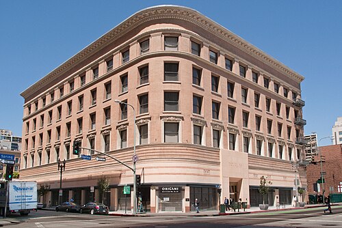 อาคารดักลาส (ค.ศ. 1899– ) มุมตะวันตกเฉียงเหนือ
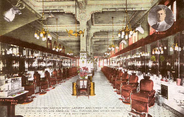 ร้านตัดผม Metropolitan Barber Shop เลขที่ 215 W. 3rd (ถูกรื้อถอนไปแล้ว)
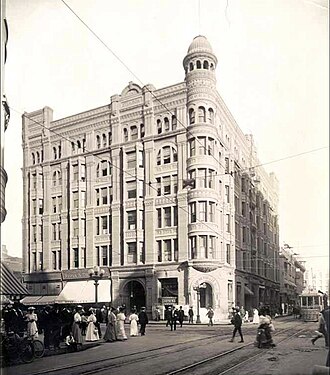 อาคารสติมสัน มุมตะวันออกเฉียงเหนือ (ค.ศ. 1893–1963)
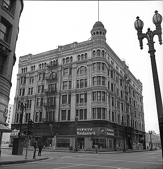 สติมสัน บล็อก ในช่วงกลางศตวรรษที่ 20
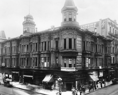 โรงแรมราโมนา มุมตะวันตกเฉียงใต้ (ค.ศ. 1885–1903)
 อาคารวอชิงตัน (ปี 1912) ที่มุมตะวันตกเฉียงใต้
 อาคารลันเคอร์ชิม (ค.ศ. 1896–1959) มุมตะวันออกเฉียงใต้
 ปัจจุบันอาคารสำนักงานรัฐบาลโรนัลด์ เรแกน ตั้งอยู่มุมตะวันออกเฉียงใต้ของถนนสายที่ 3 และถนนสปริง โดยมีถนนสปริงไหลผ่านด้านขวาของอาคาร ภาพนี้มองไปทางทิศใต้บนถนนเมน
มุมตะวันตกเฉียงเหนือของถนนเธิร์ดและถนนสปริง
- อาคารแฮมเมลและเดนเกอร์ (เปิดในปี 1890 รื้อถอนในปี 1899); [ 106 ]เฮนรี แฮมเมลและแอนดรูว์ เอช. เดนเกอร์เป็นหุ้นส่วนทางธุรกิจในโรงแรมและฟาร์มปศุสัตว์โทมัส ดักลาส สติมสันซื้ออาคารนี้ในปี 1893 จึงเป็นเจ้าของอาคารสองหลังที่ทางแยกนี้ ได้แก่ อาคารนี้และอาคารสติมสัน (ดูด้านล่าง) แฟรงค์ เกรย์ แอนด์ โค ผู้ค้าปลีกสินค้าแห้งชั้นนำ เปิดร้านที่นี่ในปี 1890 [ 107 ]และต่อมาร้านค้านี้ถูกซื้อและเปลี่ยนเป็นสาขาของเจเอ็ม เฮล[ 108 ]
- อาคาร Hammel & Denker ถูกรื้อถอนและแทนที่ด้วยอาคาร Douglasในปี พ.ศ. 2442 และยังคงตั้งอยู่จนถึงปัจจุบัน ซึ่งปัจจุบันเป็นคอนโดมิเนียม[ 109 ]
- ทางทิศตะวันตกของ Douglas Block เป็นที่ตั้งของร้านตัดผม Metropolitan Barber Shopซึ่งเดิมอยู่ที่ 214 W. 3rd ต่อมาในปี พ.ศ. 2451 ได้ย้ายไปอยู่ที่ 215-9 W. 3rd หนังสือพิมพ์Los Angeles Heraldอ้างว่าเป็นร้านตัดผมที่ใหญ่ที่สุดในโลกในเวลานั้น และเป็นร้านตัดผมที่แพงที่สุดเท่าที่เคยสร้างมา โดยมีเก้าอี้ 30 ตัว โคมระย้า และเฟอร์นิเจอร์ไม้มะฮอกกานี[ 110 ]
มุมตะวันออกเฉียงเหนือของถนนเธิร์ดและถนนสปริง
- อาคารสติมสันหรืออาคารสติมสันสร้างขึ้นในปี 1893 ออกแบบโดยสถาปนิก แคร์โรลล์ เอช. บราวน์ (ซึ่งเป็นผู้ออกแบบบ้านสติมสัน ด้วย ) ถูกรื้อถอนในปี 1963 เคยเป็นอาคารที่สูงที่สุดของเมืองเมื่อเปิดใช้งาน สร้างขึ้นเพื่อโทมัส ดักลาส สติมสัน มหาเศรษฐีด้านไม้ ปัจจุบันเป็นที่ตั้งของลานจอดรถ[ 111 ]
มุมตะวันตกเฉียงใต้ของถนนเธิร์ดและถนนสปริง
- อาคารCallaghan BlockหรือRamona Blockซึ่งเป็นที่ตั้งของโรงแรม Ramona (สร้างในปี 1885 โดยBurgess J. Reeveออกแบบสไตล์หน้าต่างโค้งแบบคลาสสิก) [ 112 ]ถูกรื้อถอนในปี 1903 และแทนที่ด้วยอาคาร Washington Buildingซึ่งสร้างในปี 1912 โดยParkinson และ Bergstromซึ่งยังคงตั้งอยู่จนถึงปัจจุบัน[ 113 ] [ 114 ]
มุมตะวันออกเฉียงใต้ของถนนเธิร์ดและถนนสปริง
- ที่ตั้งของอาคาร Lankershim (ค.ศ. 1896-7 โดยRobert Brown Youngถูกรื้อถอนในปี ค.ศ. 1959) [ 115 ]ปัจจุบันเป็นที่ตั้งของอาคาร Ronald Reagan State Building
ถนนสายหลัก
 ภาพถ่ายถนนเมนสตรีทมองไปทางทิศเหนือจากเทมเปิล ถ่ายโดย ที.อี. สแตนตัน ปี 1886 อาคารเบเกอร์บล็อกเป็นอาคารที่โดดเด่นอยู่ด้านหลัง ด้านซ้าย: โรงแรมคอสโมโพลิแทน ธนาคารฟาร์เมอร์สแอนด์เมอร์แชนท์ส อาคารดาวนีย์บล็อกพร้อมร้านอาหารคอมเมอร์เชียล
ถนนสายหลักจากพลาซ่าไปทางใต้สู่ Arcadia
แกลเลอรี (ฝั่งตะวันตก)
 อาคารเซนทัสหรือ อาคารเซนทัส สร้างขึ้นในปี 1920


Gallery (east side)
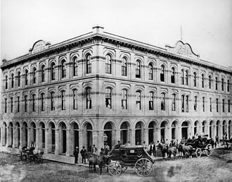 Pico House in 1875
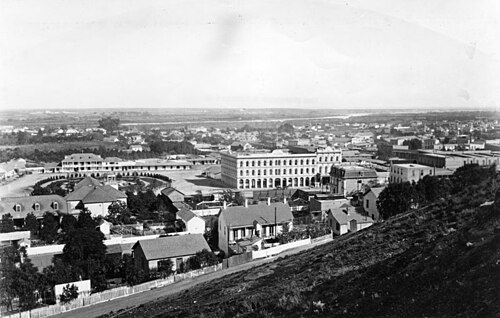 Pico House and the Plaza in 1876, photo taken from Fort Moore
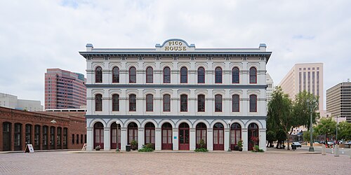 Pico House today
 Pico House, Merced Theater and Masonic Hall
Pico House
Pico House was a luxury hotel built in 1870 by Pío Pico, a successful businessman who was the last Mexican Governor of Alta California. With indoor plumbing, gas-lit chandeliers, a grand double staircase, lace curtains, and a French restaurant, the Italianate three-story, 33-room hotel was the most elegant hotel in Southern California. It had a total of nearly eighty rooms. The Pico House is listed as a California Historical Landmark (No. 159).
Masonic Hall
Masonic Hall at 416 N. Main St., was built in 1858 as Lodge 42 of the Free and Accepted Masons. The building was a painted brick structure with a symbolic "Masonic eye" below the parapet. In 1868, the Masons moved to larger quarters further south. Afterward, the building was used for many purposes, including a pawn shop and boarding house. It is the oldest building in Los Angeles south of the Plaza.
Merced Theater
The Merced Theater, completed in 1870, was built in an Italianate style and operated as a live theatre from 1871 to 1876. When the Woods Opera House opened nearby in 1876, the Merced ceased being the city's leading theatre.[116] Eventually, it gained an "unenviable reputation" because of "the disreputable dances staged there, and was finally closed by the authorities."[117]
Plaza House
This two-story building at 507–511 N. Main St. houses part of the LA Plaza de Cultura y Artes, which includes the Vickrey -Brunswig Building next door.[118] It is inscribed on its upper floor, and on 1890s maps it is marked, "Garnier Block" (not to be confused with the Garnier Block/Building on Los Angeles Street, one block away). Commissioned in 1883 by Philippe Garnier, once housed the "La Esperanza" bakery.[119]
Vickrey-Brunswig Building
This five-story brick building facing the Plaza at 501 N. Main St. houses LA Plaza de Cultura y Artes, which also occupies the Plaza House next door. It was built in 1888 and combines Italianate and Victorian architecture; the architect was Robert Brown Young.[120]
Site of Sentous Building
The Sentous Block or Sentous Building (19th c., demolished late 1950s) was located at 615-9 N Main St., with a back entrance on 616-620 North Spring St. (previously called Upper Main St., then San Fernando St.). Designed in 1886 by Burgess J. Reeve. Louis Sentous was a French pioneer in the early days of Los Angeles.[121] The San Fernando Theatre was located here. The site is now part of the El Pueblo parking lot.[122][123]
West side of Main from Republic south to Temple
 St. Elmo (orig. Lafayette) Hotel circa 1890
This block is part of the site of the current Spring Street Courthouse. Buildings previously located here include:
- Lafayette Hotel, 343 N. Main, opened in the 1850s, c.1882 renamed the Cosmopolitan Hotel, then the St. Elmo Hotel.[124] Razed in 1933.[125]
- Farmers and Merchants Bank of Los Angeles location from 1874 through 1883, after leaving their original quarters in the Pico Building. Architect Ezra F. Kysor.[126][127]
Northwest corner of Temple and Main
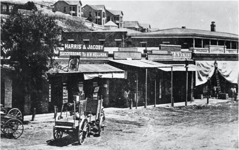 View to the NW of Old Downey Block, c.1870, before Downey Block was built in 1871: "Harris & Jacoby", forerunners to Harris & Frank and Jacoby Bros., and M. Kremer, forerunner of the City of Paris, the city's first department store
 South end of the Downey Block, at the NW corner of Temple/Main, 1880s
 North end of the Downey Block along the west side of Main St., 1887. Temple Block at left; Spring Street runs towards the Phillips Block (tower) in the background at center-left.
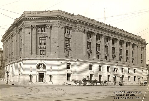 1910 Post Office and Courthouse which replaced the Downey Block NW corner Temple and Main
 The 1940 Spring Street Courthouse, NW corner Temple/Main, 2008
On this corner stood four buildings in succession, the first two of which had a key role in the history of retail in Southern California, as it was home to a number of upscale retailers who would later grow to be big names in the city, and some, regional chains.
- Old Downey Block (?-1871), northwest corner of Temple and Main, Replaced by the Downey Block (1871-1910). Retailers that got their start here included Harris & Jacoby,[128][129] forerunners to the Harris & Frank clothing chain and the large Jacoby Bros. department store; and M. Kremer,[130] forerunner of the Los Angeles City of Paris.
- Downey Block (1871–1910), replaced by the New Post Office in 1910. Retailers who were located here included Coulter's (1878-9),[131]Jacoby Bros. (1878-9),[132] and Quincy Hall (1876–1882),[133] forerunner of Harris & Frank.
- New Post Office also known as the Federal Building (1910–1937). Razed in 1937 and replaced by a new Federal Building now known as the Spring Street Courthouse, opened in 1940.[134]
- Spring Street Courthouse, opened in 1940.[134]
East side of Main from Arcadia south to Commercial
Baker Block
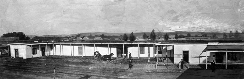 Abel Sterns adobe c.1857. Built in 1835-1838, demolished in 1877 to make way for the Baker Block
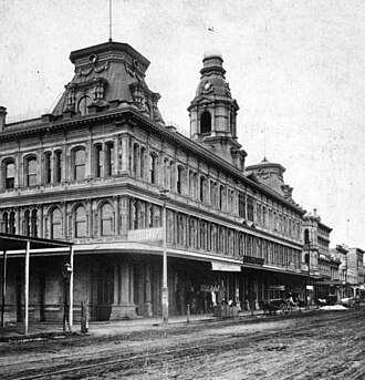 Baker Block, built 1878, demolished 1942, site now under US 101 freeway. Photo c.1880
 Lithograph of the Baker Block
- Baker Block, 334–348** N. Main at the southeast corner of Arcadia Street, opened late 1878, Second Empire architecture. The Baker Block was erected on the site of Don Abel Stearns' adobe mansion also called El Palacio, built in 1835-1838 and demolished in August and September of 1877;[135] Col. Robert S. Baker who had the Baker Block built, had married Stearns' widow, Arcadia Bandini de Stearns Baker. When built, it was called the "finest emporium of commerce south of San Francisco". The ground floor housed retail tenants such as Coulter's (1879–1884), George D. Rowan and Eugene Germain. The second floor was offices, and the third floor held the city's most upscale apartments. In 1919, Goodwill Industries bought the building and opened its store and operations. That is not to say though, that nobody fought to save the building. The Metropolitan Garden Association tried to move the Baker Block to another location for use as a public recreation center, while city councilman Arthur E. Briggs raised funds to convert the building into a city history museum. Nonetheless, in 1941, Goodwill sold the building to the city, which demolished it in 1942. Currently, the US 101 freeway, and the new, more southerly route of Arcadia Street, run over most of the site.[136]
South of Baker Block
 c.late 1870s: Grand Central Hotel branded as part of the St. Charles, Bank of Los Angeles in the Pico Bldg., St. Charles hotel proper, 312 bldg. and L. Harris store, forerunner of Harris & Frank
 Sketch of east side of the 300 block of North Main Street, between Arcadia and Commercial streets, as it appeared circa 1880
 Downey ("Libería Española"), Grand Central ("Osaka Co.", "Chop Suey"), Pico ("Arizona Cafe", "Money to Loan"), Bella Union/St Charles ("Azteca"), 312 and 306-8 buildings, 1930s.
 2005 view. Main St. runs along the left (west) side from the Plaza area (top left), over US 101 (site of the Baker Block) and along the western edge of the Los Angeles Mall (bottom center), site of the buildings described below (Downey Building through Ducommun Block).
South of the Baker Block stood buildings that are now the site of the northwestern-most part of the Los Angeles Mall:
- Downey Building (not to be confused with the "Downey Block"), 324–330** N. Main, opened 1878, three stories, captured in a 1957 color photo standing alone as the last building on the block, demolished that year.[137] In the 1930s photo above, it is home to the Librería Española.
- Grand Central Hotel, opened 1876, demolished.
- Pico Building, 318-322** N. Main, opened 1867, the city’s first bank building, to house the new Hellman, Temple & Co. bank, then in 1871 the first location of Hellman’s own bank Farmers and Merchants Bank of Los Angeles, forerunner of Security Pacific National Bank. Later tenants included the Los Angeles County Bank (1874-1878), Charles H. Bush, jeweler and watchmaker (1878-1905), Louis E. Pearlson’s jewelry, loan and pawnshop (from 1905), as well as several barber shops and then a succession of owner-operated restaurants. The last occupants were a jewelers and the Mexican restaurant Arizona Cafe #2. Demolished 1957 to make way for a parking lot.[138]
- Bella Union Hotel, later the St. Charles Hotel, 314–316** N. Main. Opened 1835, demolished 1940. Home to the Azteca Cafe in the 1930s.
- 312 N. Main, two stories, home to a saloon in the mid-1890s
- 306–308 N. Main, three stories, home to offices (at #308) and Bright's Cheap Store (#306) in 1882.[139]
- Ducommun Block or Ducommun Building, 300-2-4** N. Main (200-2-4* N. Main). In the 1880s, home to the Ducommun hardware store, a furniture store and Prager Dry Goods. In the early 20th century, site of the Security Pacific National Bank.[140] Home to the Federal Theatre from c.1913–1917.[141]
The Los Angeles Mall replaced these blocks; it is a small shopping center at the Los Angeles Civic Center, between Main and Los Angeles Streets on the north and south sides of Temple Street, connected by both a pedestrian bridge and a tunnel. It features Joseph Young's sculpture Triforium, with 1,500 blown-glass prisms synchronized to an electronic glass bell carillon. The mall opened in 1974 and includes a four-level parking garage with 2,400 spaces.
East side of Main from Commercial south to First
 The 1888 New Lanfranco Block, early 1920s
 Main and Requena: United States Hotel right, Victorian 200–202 N. Main at left (Southern Pacific ticket office in 1888)
 United States Hotel, SE corner Requena/Main. c.1880
 Triforium sculpture at the Los Angeles Mall just N of the NE corner of 1st/Temple, 2018.
Currently, this site is the southernmost end of the Los Angeles Mall; Triforium is approximately on the site of Commercial Street.[142]
- #240 Farmers and Merchants Bank was located here in 1896[142]
- #236 Los Angeles Savings Bank was located here in 1896[142]
- #226-8 Commercial Bank, renamed First National Bank in 1880, was located here in 1896.[143]First National Bank was located here in 1896.[142]
- #214–222 (pre-1890 numbering: 74): New Lanfranco Block, built 1888, architects Curlett, Eisen & Cuthbertson[144] Site of the Old Lanfranco Block, demolished in 1888.[145][142]
- #200–202 (NE corner of Requena) Southern Pacific ticket office as of 1888-9[146]
- #158–172: United States Hotel, southeast corner of Main and Requena St. (a.k.a. Market St.). Built 1861-2, demolished 1939. When built it was one of three hotels in the city, alongside the Bella Union and the Lafayette Hotel. It was ornate and Italianate in style, with a "profusion of brackets, corbel tables and oriel windows. On one end, a tower with a mansard roof lit by l'oeil de boeuf windows, poked up another story to signal the hotel's location to travelers.”[147] Today, location of the south plaza of the Los Angeles Mall.
West side of Main from Temple south to First
 Illich's Restaurant ad from March 1890
This block is, since 1928, the site of Los Angeles City Hall
- Before 1926, Spring Street and Main Street met at Temple Street. From Temple, Main and Spring streets proceeded south; Spring at a more southwesterly angle. This created a narrow triangle with the triangle's northern point at Temple. Proceeding south along Main on the right-hand side one would pass the east side of Temple Block.
- Junction with Market Street
- Clock Tower Courthouse until demolished in 1895, or the Bullard Block built in its place after 1895.
- Junction with Court Street
- Illich's Restaurant and Oyster Parlors, 41–43 (pre-1890 numbering) 145–7 (post-1890) N. Main St.. Starting in the 1870s as a small chophouse, Illich's grew to be the largest restaurant in the city. Owner Jerry Illich was born in Dalmatia. He was connected with the Maison Doree restaurant at 4th and Main and later opened his own restaurant in 1896 on west 2nd Street between Broadway and Hill.[148]
- Northwest corner of First and Main streets.
East side of Main from First to Second
 Two horsecars pass in a blur c.1889. Looking north along Main from just south of 1st Street. Grand Opera House at right. Towers of the United States Hotel at back, behind which the towers of the Baker Block.
 Grand Opera House, 110 S. Main, c.1884–1893
 Orpheum Theatre when located at the Grand Opera House building, c.1898
 Forster Block
- Grand Opera House (1884, demolished 1936, capacity 1311, 110 S. Main, in later years known as the Orpheum (Dec. 1894–Sep. 1903), Clune's Grand (c.1912), The Grand (c.1920s), and Teatro México (1930s). (The Orpheum Circuit (circuit meaning "chain") moved the Orpheum name to a different venue in 1903 at 227 S. Spring, and again in 1911 to what is now the Palace Theatre). This theater was the site of the first commercial showing of motion pictures in the city. Demolished in 1936 to make way for a parking lot.[149][150]
- Forster Block, 122–128 S. Main St. (post-1890 numbering), 22–28 S. Main St. (per-1890 numbering), was a two-story building built in the early 1880s, five doors south of the Grand Opera House. It housed a coffee house of the Women's Christian Temperance Union at #26, heavily damaged in an 1885 fire, and a saddlery.[151]
Third from Spring to Main, Third and Main
 c.1887 view looking east along south side of 3rd Street incl. former New York Brewery, towards Main (across top). Back left: The Thom Block. Back right: Olmsted & Wales bookstore in the Panorama Building.
 Panorama Building, E side of Main between Mayo (3rd) and 4th, c.1890. The center entrance led through to the panorama exhibition space in the back. Note the Olmsted & Wales Panorama Bookstore, and the offices of the Evening Express. At right, the Hotel Westminster at the NE corner of 4th/Main.
On the corner of Third and Main:[152]
- Wells Fargo and Co. offices, northwest corner of 3rd/Main as of 1894
- The Thom Block, southeast corner of Mayo/Third and Main as of 1894
- Schwartz Block and Jackson House, southwest corner of 3rd/Main as of 1894
Buildings along Los Angeles Street
 Old Chinatown stretched from Sanchez Street across Los Angeles Street to what is now Union Station. c.1885.
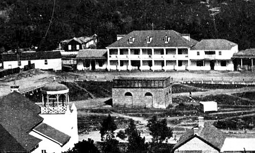 Lugo Adobe lining the eastern edge of Los Angeles Plaza. The street in front of the adobe was part of Los Angeles St. starting in the 1880s.
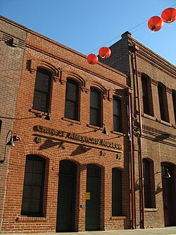 Chinese American Museum in the Garnier Building
 1882 view, looking north from Broad Place along Calle de los Negros to the Ignacio Del Valle adobe in the far background. At left, with the peeling paint, is the Coronel Adobe (SE corner of Arcadia). A few years later, both adobes would be demolished and Los Angeles St. would be extended northward to (and past) the Plaza.
 Looking east on Arcadia towards houses lining the east side of Broad Place. Aliso Street runs form their right side towards the background. Calle de los Negros runs to the left in front of them. The Coronel Adobe is at left.
 Adobes in Calle de los Negros
 Broad Place at north end of Los Angeles Street c.1870s. At back, Coronel Adobe (l), Calle de los Negros (r)
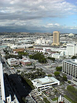
Northern end of Los Angeles Street

The Coronel Adobe was demolished in 1888 and 1896 Sanborn maps show that the Del Valle adobe had been removed, and Los Angeles Street had been extended[153] to form the eastern edge of the Plaza, thus passing in front of the Lugo Adobe. Calle de los Negros remained for a few more decades, behind a row of houses lining the east side of Los Angeles Street between Arcadia and Aliso streets. This was also the western edge of Old Chinatown from around the 1880s through 1930s. It reached eastward across Alameda St. to cover most of the area that is now Union Station. It proceeded one more block past the Plaza, with the buildings on the east side of Olvera Street forming its western edge, until terminating at Alameda Street.[154]
Eastern edge of Plaza
Since the early 1950s, Los Angeles Street has formed the eastern edge of the Plaza, but the buildings lining its eastern edge, including the Lugo Adobe, were removed.[155][156] The site is now Father Serra Park.
From the Plaza north to Alameda

When it was extended past the Plaza in 1888,[153] Los Angeles Street terminated one short block north of the Plaza at Alameda Street. Now, Los Angeles Street turns east at the north side of the Plaza to terminate at Alameda Street at a right angle, directly across from the Union Station complex. What was the short block of Los Angeles Street north of the Plaza is now part of Placita Dolores, a small open plaza which surrounds a statue of Mexican charro entertainer Antonio Aguilar on horseback.[157]
Calle de los Negros
Until the late 19th century, Los Angeles Street did not form the east side of the Plaza; it ran south only from Broad Place at the intersection of Arcadia Street. Here, the Coronel Adobe blocked the path north one block to the Plaza, but just slightly to the right (east) of the path of Los Angeles Street was Calle de los Negros (Spanish-language name; marked on post-1847 maps as Negro Alley or Nigger Alley), a narrow, one-block north–south street likely named after darker-skinned Mexican afromestizo and/or mulatto residents during the Spanish colonial era.[158][159]. At the north end of Calle de los Negros stood the Del Valle adobe (also known as the Matthias or Matteo Sabichi house),[160][161] at the southern edge of which one could turn left and enter the plaza at its southeast corner. Calle de los Negros was famous for its saloons and violence in the early days of the town, and by the 1880s was considered part of Chinatown, lined with Chinese and Chinese American residences, businesses and gambling dens.[162][163]
The neglected dirt alley was already associated with vice by the early 1850s, when a bordello and its owner both known as La Prietita (the dark-skinned lady) were active here. Its other businesses included malodorous livery stables, a pawn shop, a saloon, a theater and a connected restaurant. Historian James Miller Guinn wrote in 1896, "in the flush days of gold mining, from 1850 to 1856, it was the wickedest street on earth...In length it did not exceed 500 feet, but in wickedness, it was unlimited. On either side it was lined with saloons, gambling hells, dance houses and disreputable dives. It was a cosmopolitan street. Representatives of different races and many nations frequented it. Here the ignoble red man, crazed with aguardiente, fought his battles, the swarthy Sonorian plied his stealthy dagger, and the click of the revolver mingled with the clink of gold at the gaming table when some chivalric American felt that his word of “honah” had been impugned."[158]
By 1871, the alley was notorious as a "racially, spatially, and morally disorderly place", according to historian César López. It was here that a growing number of Chinese immigrant railroad laborers settled after the completion of the transcontinental railroad in 1869. There, William Estrada notes, the "Chinese of Los Angeles came to fill an important sector of the economy as entrepreneurs. Some became proprietors and employees of small hand laundries and restaurants; some were farmers and wholesale produce peddlers; others ran gambling establishments; and some occupied other areas left vacant by the absence of workers in the gold rush migration to California." The Chinese population increased from 14 in 1860 to almost 200 by 1870. Guinn stated that the alley stayed "wicked" through and after its transition to the city's Old Chinatown.[158]
Calle de los Negros was reconfigured in 1888 when Los Angeles Street was extended north, with a small, shallow row of houses remaining between the new section of Los Angeles street's eastern edge and the western edge of the new, shortened alley.[153][164] The site of Calle de los Negros is now the Pueblo parking lot and a cloverleaf-style entrance to the US 101 freeway.
Coronel Adobe
The Coronel Adobe was built in 1840 by Ygnacio Coronel as a family home. It stood at the northwest corner of Arcadia Street and Calle de los Negros; Los Angeles Street terminated at its southern end. The area gradually became an area for gambling and saloons, and upper-class families left to live elsewhere. Around 1849, they sold the house to a "sporting fraternity", which operated a popular 24-hour gambling establishment with games including monte, faro, and poker; up to $200,000 in gold could be seen on the tables at a time. Arguments ensued and murders were frequent. The building later became a dance hall where "lewd women" were employed, aimed at the Mexican-American population. After that, still in the 1850s, it became a grocery and dry goods store (Corbett & Barker), then a storage house for iron and hard lumber for Harris Newmark Co. It was then leased to a Chinese immigrant. In 1871, it was the site of the Chinese massacre of 1871. The Adobe was torn down in 1888 in order to extend Los Angeles Street north past the Plaza.[153]
Garnier Building
At 419 N. Los Angeles Street, at the northwest corner of Arcadia, is the Garnier Building, built in 1890, part of the Los Angeles' original Chinatown. The southern portion of the building was demolished in the 1950s to make way for the Hollywood Freeway. The Chinese American Museum is now located in the Garnier Building. It should not be confused with another Garnier Block/Building on Main St. a block away now commonly known as Plaza House.
 Haas, Baruch & Co., successor to Hellman, Haas & Co., SE corner of Aliso St. c.1890s
 1885 view of the east side of Los Angeles St. with Bell Block at center with its two story porch, to its right Mellus Row, then Hellman, Haas & Co. At center is Aliso St. heading east (top center of photo).
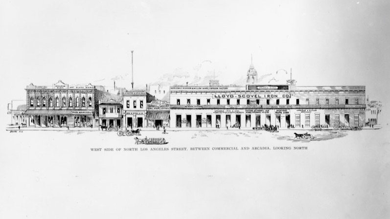 West side of Los Angeles street from Arcadia to Commercial, 1890s. Hellman Block at left, Arcadia Block at right
 Arcadia Block, 1870s. SW corner of Los Angeles and Arcadia streets.
 Los Angeles St. north from 1st St. ca. 1910
 Los Angeles St. north from 3rd St. ca. 1910
Los Angeles Street was lined with mostly commercial buildings; the southeast end of the business district around Los Angeles and 3rd streets was the Wholesale District. Only a few buildings were notable:
West side south of Arcadia
- Arcadia Block: southwest corner of Arcadia Street. Built 1858, razed in 1927.[165]
- Hellman Block: in 1870, banker and University of Southern California founder Isaias W. Hellman erected the Hellman Block at the northwest corner of Los Angeles and Commercial streets.[166] This is one of several Hellman Blocks or Hellman Buildings in the city.
East side south of Aliso
- Bell Block was at the southeast corner of Aliso Street. It was General John C. Fremont's headquarters and the first Los Angeles City Hall. Captain Alexander Bell and Mellus lived here (Francis Mellus married a niece of Mrs. Bell's). It was taken over by General Fremont for his headquarters and thus became the state capital for the short period of his acting as governor. The Los Angeles City organization was formed in this building in 1850.[167]
- Mellus Row, adjacent to Bell Block on the south
- Hellman, Haas & Co. grocers (a partnership of Abraham Haas and Herman W. Hellman), the predecessors of Smart & Final. Located in the 1880s and 1890s at 218-224 (pre-1890 numbering, post-1890 numbering: 318-324) N. Los Angeles St., adjacent to Mellus Row on the south.[168] Not to be confused with the Haas Building.
- Between Aliso and Temple streets on the east side of Los Angeles St. at #300 is the Federal Building, opened in 1965-6, architect Welton Becket.[169] Temple was extended east of Main Street between Aliso Street and a street that was known as both Requena and Market street. Adjacent and to its east is the Edward R. Roybal Federal Building and United States Courthouse, completed in 1992.
- Between Temple and First streets is Parker Center, the Los Angeles Police Department headquarters from 1955–2009
- At the southeast corner of First Street, Little Tokyo begins. At this corner was the Tomio Department Store, and two more Japanese-American department stores, the Asia Company and Hori Brothers were located east of it on 1st Street during the 1920s.[170] Now the site of Weller Court and the DoubleTree by Hilton Hotel Los Angeles Downtown, formerly the New Otani Hotel.
Transportation
 Lithograph showing the Baker Block and horse-drawn streetcar, c.1890
 Cable car of the Temple Street Cable Railway in 1890 at Fort (Broadway) at Temple streets looking northwest
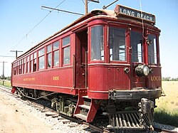 "Red car" of the Pacific Electric
 A Los Angeles Railway electric streetcar, 1891
 Main Street & Agricultural Park electric streetcar, c.1896
 A Los Angeles Railway electric streetcar, c.1900-1910
Horsecars (1874–1897)
- Horse-drawn streetcars started with the Spring and Sixth Street Railroad in 1874. The last horsecars were converted to electric in 1897.[171][172]
Cable cars (1885–1902)
Cable car street railways in Los Angeles first began operating up Bunker Hill in 1885, with a total of three companies operating in the period through 1902,[173] when the lines were electrified and electric streetcars were introduced largely following the cable car routes. There were roughly 25 miles of routes, connecting 1st and Main in what was then the Los Angeles Central Business District as far as the communities known today as Lincoln Heights, Echo Park/Filipinotown, and the Pico-Union district.
Electric streetcar systems (1887–1963)
Electrically-powered streetcar systems were numerous starting with the Los Angeles Electric Railway in 1887, but were over time consolidated into two large networks:
- In 1901, Henry Huntington bought various electric streetcar companies operating mostly within the City of Los Angeles (and not in the San Fernando Valley, Harbor area or Westside) and combined them into the Los Angeles Railway with its "yellow cars".
- In 1902, Huntington and banker Isaias W. Hellman established the Pacific Electric Railway, which would acquire other railways, providing interurban service to surrounding towns in what is now Greater Los Angeles (Los Angeles, Orange, San Bernardino and Riverside counties) and new suburban developments. The Pacific Electric Building, with station underneath, was opened in 1905 at 6th and Main Street.
Funiculars
Angel's Flight and Court Flight were funicular railways operating from Broadway up Bunker Hill.
Railroad depots
 Los Angeles & San Pedro Railroad Depot, SW corner Alameda and Commercial streets, c.1880
 Los Angeles and Independence Railroad Depot, 5th & San Pedro streets, c.1875
 Southern Pacific Railroad's Arcade Depot, Alameda between 5th/6th, c.1895-1900
 Central Station of the Southern Pacific Railroad c.1918, Central & 5th streets, c.1918
 La Grande Station of the Atchison, Topeka and Santa Fe Railway, Santa Fe and 2nd streets, c.1915
- Los Angeles & San Pedro Railroad Depot, SW corner Alameda and Commercial streets
- Los Angeles and Independence Railroad Depot, San Pedro and 5th street (southeast of the business district)
- Arcade Depot of the Southern Pacific Railroad along Alameda Street between 5th to 6th streets. Opened 1888, closed 1914.
- La Grande Station of the Atchison, Topeka and Santa Fe Railway, Santa Fe at 2nd (East of the business district), opened 1893, closed 1939
- Central Station of the Southern Pacific Railroad, Central and 5th streets (southeast of the business district), opened 1914. Union Pacific Railroad started operating from the station in 1924. Disused 1939.
- Union Station was opened in 1939, replacing the existing Central and La Grande stations.
Landmarks shown on schematic map
This is a map of the former and current buildings located in the Victorian business district of Los Angeles around 1890–1905.
Abbreviations and notes
- CH = Concert Hall
- "Female boarding" was a euphemism for small rooms, "cribs", used by prostitutes.[174]
- †(Dagger) indicates a street that no longer exists
Building numbering is according to the system introduced in 1890.[175]
To be read like a map:
| now US 101 1951–pres[176] | formerFORTST.nowBROADWAY | now US 101 | formerBUENAVISTAST. | now US 101 | formerNEWHIGHST. | now US 101 1951–pres[176] | SPRINGST.EXTENSION1931 | now US 101 Hollywood Freeway1951–pres[176] | MAINSTREET | Stearns House1835-77/BAKER BLOCK1875–1942now US 101 | Arcadia Block1858–1927nowUS101 | LOSANGELESSTREET | Calle de los NegrosnowUS101 | ||||||||||||||||||||||||||||||||||||||||||||||||||||||||||||||||||||||||||||||||||||||||||||||||||||||||||||||||||||||||||||||||||||||||||||||||||||||||||||||||||||||||||||||||||||||||||||||||||
FORT MOORE | ST. | ARCADIA STREETformer route | ALISO fmr. rt. | ||||||||||||||||||||||||||||||||||||||||||||||||||||||||||||||||||||||||||||||||||||||||||||||||||||||||||||||||||||||||||||||||||||||||||||||||||||||||||||||||||||||||||||||||||||||||||||||||||||||||||||
201–21 W. Temple, 131 W. Temple p1906: Hotel Aberdeen – County Jail 315 N Spring 211 W. Temple Hall of Justice1925–pres ---------- north side of Temple from Broadway to Spring St. ext. | [177] 335–47 N Lafayette Hotel/Cosmopolitan Hotel/St. Elmo Hotel 1850s–? [177] 301–25 N 1st Downey Block ?–18712nd Downey Block1871–?Post Office & Courthouse1910-1937Spring St. US Courthouse1940–pres | Grand Central Hotel1876–? Pico Bldg/ Farmers & Merchants Bank1867–1957 Bella Union/St. Charles Hotel 1835–1940 Ducommun Block/Security Pacific Bank now part of Los Angeles Mall | Hellman Block1870–? now part of Los Angeles Mall | 300–16 N [178]Bell Block (aka Bell's Row, Mellus Row) c.1845–92 318–24 N Hellman, Haas & Co.1880s-90s/Haas, Baruch & Co p1906 block is now300 N. L. A. St. Federal Bldg1965 arch. Welton Becket | |||||||||||||||||||||||||||||||||||||||||||||||||||||||||||||||||||||||||||||||||||||||||||||||||||||||||||||||||||||||||||||||||||||||||||||||||||||||||||||||||||||||||||||||||||||||||||||||||||||||||||
| SAND/CALIFORNIA | ex-COMMERCIAL ST. | ex-COMM. ST. | |||||||||||||||||||||||||||||||||||||||||||||||||||||||||||||||||||||||||||||||||||||||||||||||||||||||||||||||||||||||||||||||||||||||||||||||||||||||||||||||||||||||||||||||||||||||||||||||||||||||||||||
313 N p1894: St. Nicholas Hotel 301–5 N 1888–1950s:Temperance Templenow L. A. Co. Heating & Refrigeration Plant | 240 N Mascarel-Barri adobe 1850s[179] Arbuckle dry goods 1850s[179]John Jones wholesale grocery 1850s Adolph Portugal dry goods 1854–65[180]Hellman dry goods 1865–8[180][181]Polaski and Goodwin's dry goods 1868–c.1878[181] Farmers & Merchants Bank p1894[182]–dU.S. Nat'l Bank p1906–d 236 N L. A. Savings Bank p1894[182]–d 226–8 N Commercial Bank 1870s/1st Nat'l Bank 1880[183]–d now part ofLos Angeles Mallnorth block | 230–4 N White House hotel 1872–81/[184] Smith's hotel, rest. p1882–4/[184] European Hotel p1894/[185] New Arlington Hotel c.1910s[186]block is now300 N. L. A. St. Federal Bldg1965 arch. Welton Becket | |||||||||||||||||||||||||||||||||||||||||||||||||||||||||||||||||||||||||||||||||||||||||||||||||||||||||||||||||||||||||||||||||||||||||||||||||||||||||||||||||||||||||||||||||||||||||||||||||||||||||||||
| TEMPLE STREET | 214–22 N New Lanfranco Block 1888–d TEMPLE STREET extended 1930 | TEMPLE ST.1930–pres | |||||||||||||||||||||||||||||||||||||||||||||||||||||||||||||||||||||||||||||||||||||||||||||||||||||||||||||||||||||||||||||||||||||||||||||||||||||||||||||||||||||||||||||||||||||||||||||||||||||||||||||
Pound Cake Hilllowered c.1887–90, leveled 1961[187] High School 1873-87d/"Red Sandstone" Courthouse 1891-1936dPlaza de Justicia public space –1961 now County Courthouse1972–pres L.A. Co. Hall of Records1911-73d |
| now part ofLos Angeles Mall south block | bldgsNofMarket | ||||||||||||||||||||||||||||||||||||||||||||||||||||||||||||||||||||||||||||||||||||||||||||||||||||||||||||||||||||||||||||||||||||||||||||||||||||||||||||||||||||||||||||||||||||||||||||||||||||||||||||
| formerREQUENA ST. | former MARKET ST. | ||||||||||||||||||||||||||||||||||||||||||||||||||||||||||||||||||||||||||||||||||||||||||||||||||||||||||||||||||||||||||||||||||||||||||||||||||||||||||||||||||||||||||||||||||||||||||||||||||||||||||||||
United States Hotel1861–1939Now part of L. A. Mall south block | now City Hall East 1972–pres | Parker Center (former LAPD HQ) | |||||||||||||||||||||||||||||||||||||||||||||||||||||||||||||||||||||||||||||||||||||||||||||||||||||||||||||||||||||||||||||||||||||||||||||||||||||||||||||||||||||||||||||||||||||||||||||||||||||||||||||
Hotel Broadway dCourt Flight Funicular 1905–1943 | PHILLIPS BLOCK1887–1912Hamburger's Peoples Store 1888–1908 | ||||||||||||||||||||||||||||||||||||||||||||||||||||||||||||||||||||||||||||||||||||||||||||||||||||||||||||||||||||||||||||||||||||||||||||||||||||||||||||||||||||||||||||||||||||||||||||||||||||||||||||||
| SPRINGSTREET | ex-COURT ST. | ||||||||||||||||||||||||||||||||||||||||||||||||||||||||||||||||||||||||||||||||||||||||||||||||||||||||||||||||||||||||||||||||||||||||||||||||||||||||||||||||||||||||||||||||||||||||||||||||||||||||||||||
| formerFRANKLIN ST. | 128-38 N Jacoby Bros. DS 1879–1900 100-10 N L. A. Nat'l Bank Bldg 1887–1906[188][189]Odd Fellows Lodge p1894[190]/ Equitable Savings Bank Bldg1906-20s[191]/ Now park at City Hall | 125-31 N Hall of the Amigos del Paísc.1844-47/Dos Amigos barc.1850/60s-70s/McDonald Blkc.1876-?[192] 121-7 N Jacoby Bros. DS 1879–1900 101-11 N Lichtenberger Blocknow park at City Hall |
German-AmericanSavings Bank1894–1906now part of L .A. Mall south block | ||||||||||||||||||||||||||||||||||||||||||||||||||||||||||||||||||||||||||||||||||||||||||||||||||||||||||||||||||||||||||||||||||||||||||||||||||||||||||||||||||||||||||||||||||||||||||||||||||||||||||||
Tajo Bldg1896–mid-20th c.now Law Library | LosAngelesTimesBldg#3, 1912–38now vacant lot | Larronde Block1892-c.1930/Calif. State Bldg.1931–1976now vacant lot | |||||||||||||||||||||||||||||||||||||||||||||||||||||||||||||||||||||||||||||||||||||||||||||||||||||||||||||||||||||||||||||||||||||||||||||||||||||||||||||||||||||||||||||||||||||||||||||||||||||||||||||
| FIRST ST. | FIRST ST. | FIRST ST. | FIRST ST. | FIRST ST. | |||||||||||||||||||||||||||||||||||||||||||||||||||||||||||||||||||||||||||||||||||||||||||||||||||||||||||||||||||||||||||||||||||||||||||||||||||||||||||||||||||||||||||||||||||||||||||||||||||||||||||
107: Old J. Serra State Office Bldg 1958–2006[193] now1st St. Courthouse2016, entire block #127 Mason Opera House 1902-56[194] #141–145Frost (Haig M. Prince) Bldg 1898–1960 JP[195] Parking structure 1960–97[193] | Culver Block/ nowTimes Mirror Sq. Pereira Bldg1973–pres 128-130Southwest Bldg 1903–?Chamber of Commerce;The Herald | Nadeau H.1882–1932nowTimes Mirror Sq. Kaufmann Bldg 1935–pres. | Wilson Block1886–d | Natick House1883–1950 JP |
#110: Grand Opera House/Orpheum Theatre #1[196]
Now Caltrans(entire block) | Doubletree Hotel (ex-New Otani)1977–presWeller Court mall | |||||||||||||||||||||||||||||||||||||||||||||||||||||||||||||||||||||||||||||||||||||||||||||||||||||||||||||||||||||||||||||||||||||||||||||||||||||||||||||||||||||||||||||||||||||||||||||||||||||||||
1st Roeder BlkBryson BlkMueller's Blk | Now LAPD HQ2009, entire block | ||||||||||||||||||||||||||||||||||||||||||||||||||||||||||||||||||||||||||||||||||||||||||||||||||||||||||||||||||||||||||||||||||||||||||||||||||||||||||||||||||||||||||||||||||||||||||||||||||||||||||||||
#138Hellman Bldg.1897-1959now parking garage | Bryson-BonebrakeBlock1888now Times Mirror Sq. Crawford Bldg 1948–pres | Corfu Hotel Burdick Blockk/American Bank Bldg 1888-d | Newell Block | ||||||||||||||||||||||||||||||||||||||||||||||||||||||||||||||||||||||||||||||||||||||||||||||||||||||||||||||||||||||||||||||||||||||||||||||||||||||||||||||||||||||||||||||||||||||||||||||||||||||||||||
| SECOND ST. | SECOND ST. | SECOND ST. | SECOND ST. | SECOND ST. | |||||||||||||||||||||||||||||||||||||||||||||||||||||||||||||||||||||||||||||||||||||||||||||||||||||||||||||||||||||||||||||||||||||||||||||||||||||||||||||||||||||||||||||||||||||||||||||||||||||||||||
201-5 American Nat'l/California Bank 1878-1911/ 2nd Calif. Bank Bldg 1911–? now Broadway Media Center |
| 200–10 Wilcox Bldg1895/6–pres | Higgins Bldg.1910 | Little Tokyo district | |||||||||||||||||||||||||||||||||||||||||||||||||||||||||||||||||||||||||||||||||||||||||||||||||||||||||||||||||||||||||||||||||||||||||||||||||||||||||||||||||||||||||||||||||||||||||||||||||||||||||||
207-11 YMCA Bldg1889-1911/Merchants Trust Co. Bldg. 1910–?now parking lot 213-223 Potomac Block1890–1953Ville de Paris DS1893–1905Coulter's DS 1905–17now parking lot 237-41 J. W. Robinson's Boston Dry Goods1895–1915 Now church | Now parking garage. 212-6 Crocker Bldg Victor Clothing1926–1964 218-24 Temple B’nai B’rith1872/3–95[199][197] Copp Bldg 1896–pres[199]Pig 'n Whistle 226-8 City Hall 1888-1928 Now parking garage. 240-6 Hosfield Bldg 1914–presCity Hall NorthNatatoriumVictor Clothing1964–2001 | Now parking garage. 225-235 Perry Bldg 227 1st Los Angeles Theatre/2nd Orpheum Theatre/Lyceum Theatre1888–1941[200] 229 Turnverein (Lyceum) Hall 1894–1950s 243-7 Woollacott Bldg Now parking garage. | 212–8 Wilcox Annex 220–8 Stowell Block p1894[190]L. A. Athletic Club p1894[190]German Bldg p1906 230–4 Workman Block p1894[190] | 251 1924–40: Arrow Th.1940–5: Aztec Th.1945–80: Linda Lea Th.2007–8: Imaginasian Th.2008–20: Downtown Independent th. | 214 St. Vibiana Bldg 1876–prescathedral 1876–1994now culinary event center[201] | ||||||||||||||||||||||||||||||||||||||||||||||||||||||||||||||||||||||||||||||||||||||||||||||||||||||||||||||||||||||||||||||||||||||||||||||||||||||||||||||||||||||||||||||||||||||||||||||||||||||||||
249–59 Irvine Byrne Block, now Pan American Lofts1895–pres | 248-62 Rindge Bldg c.1901–pres | Metropolitan Barber Shop[202] | 249-257 Douglas Bldg1897–pres | 250-60 Stimson Bldg1893–1963 | Now misc. retail | Now parking garage. | |||||||||||||||||||||||||||||||||||||||||||||||||||||||||||||||||||||||||||||||||||||||||||||||||||||||||||||||||||||||||||||||||||||||||||||||||||||||||||||||||||||||||||||||||||||||||||||||||||||||||
| THIRD ST. | THIRD ST. | THIRD ST. | THIRD ST. | THIRD ST. | |||||||||||||||||||||||||||||||||||||||||||||||||||||||||||||||||||||||||||||||||||||||||||||||||||||||||||||||||||||||||||||||||||||||||||||||||||||||||||||||||||||||||||||||||||||||||||||||||||||||||||
| Hotel Ramona (?-1903)/[203]Million Dollar Theatre1917-pres | Bradbury Building1893–pres | Washington Bldg. 1912 | Lankershim Bldg.1897–1959d, Robert Brown YoungNow Reagan Bldg. | Wesley Roberts Bldg.Now Reagan Bldg. | Now parking lot. | ||||||||||||||||||||||||||||||||||||||||||||||||||||||||||||||||||||||||||||||||||||||||||||||||||||||||||||||||||||||||||||||||||||||||||||||||||||||||||||||||||||||||||||||||||||||||||||||||||||||||||
See also
External links
- Photos of Los Angeles during the 1880s and 1890s at Calisphere (University of California photo search across multiple libraries)
- Los Angeles Theatres (blog with detailed information about cinemas in Los Angeles including streetscapes, neighboring buildings, etc.)
- "Early Los Angeles city views", Water and Power Associates
- "A Visit to Old Los Angeles", with support from CSULB
- Victorian Downtown Los Angeles (blog)
34°03′11″N118°14′38″W / 34.053°N 118.244°W / 34.053; -118.244