อ่าน 97 นาที
ทางหลวงที่มีการควบคุมการเข้าออก
ทางหลวง ควบคุมการเข้าออก คือ ทางหลวง ประเภทหนึ่งที่ออกแบบมาสำหรับการจราจรของยานพาหนะความเร็วสูง โดยมีการควบคุมการไหลของจราจรทั้งหมด ทั้งขาเข้าและขาออก...
ทางหลวงที่มีการควบคุมการเข้าออก


ทางหลวงควบคุมการเข้าออก คือ ทางหลวงประเภทหนึ่งที่ออกแบบมาสำหรับการจราจรของยานพาหนะความเร็วสูง โดยมีการควบคุมการไหลของจราจรทั้งหมด ทั้งขาเข้าและขาออก คำศัพท์ภาษาอังกฤษที่ใช้กันทั่วไป ได้แก่freeway [a] motorway [ b ]และ expressway [ c ] คำศัพท์อื่นๆที่คล้ายกัน ได้แก่throughwayหรือthruway [ d ]และparkwayทางหลวงเหล่านี้บางส่วนอาจเป็นทางหลวงจำกัดการเข้าออก แม้ว่าคำนี้ยังสามารถหมายถึงทางหลวงประเภทหนึ่งที่มีการแยก จากจราจรอื่นๆ น้อยกว่าด้วย
ในประเทศที่ปฏิบัติตามอนุสัญญาวiennaการกำหนดคุณสมบัติของทางหลวงหมายความว่าห้ามเดินและจอดรถบนทางหลวง
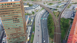
ทางหลวงที่มีการควบคุมการเข้าออกอย่างสมบูรณ์ช่วยให้การจราจรไหลลื่นโดยไม่มีสัญญาณไฟจราจรทางแยกหรือการเข้าถึงทรัพย์สินไม่มีทางข้ามระดับพื้นดินกับถนนอื่น ทางรถไฟ หรือทางเท้า ซึ่งจะใช้สะพานลอยและอุโมงค์ แทน ทางเข้าและทางออกสู่ทางหลวงมีให้ที่ทางแยกโดยใช้ทางลาด (ทางขึ้นลง) ซึ่งช่วยให้สามารถเปลี่ยนความเร็วระหว่างทางหลวงและถนนสายหลักและถนนเชื่อมต่อได้บนทางหลวงที่มีการควบคุมการเข้าออก โดยทั่วไปแล้วทิศทางการเดินทางที่สวนทางกันจะถูกแยกออกจากกันด้วยเกาะกลางถนนหรือเกาะกลางที่มีแผงกั้นจราจรหรือหญ้า การกำจัดความขัดแย้งกับทิศทางการจราจรอื่น ๆ ช่วยเพิ่มความปลอดภัยอย่างมาก[ 2 ]ในขณะเดียวกันก็เพิ่มความจุและความเร็วของการจราจร
ทางหลวงที่มีการควบคุมการเข้าออกพัฒนาขึ้นในช่วงครึ่งแรกของศตวรรษที่ 20 อิตาลีเป็นประเทศแรกในโลกที่เชื่อมต่อเมืองต่างๆ ด้วยทางหลวงที่มีการควบคุมการเข้าออกซึ่งสงวนไว้สำหรับการจราจรความเร็วสูงและสำหรับยานยนต์เท่านั้น[ 3 ] [ 4 ]อิตาลีเปิดทางหลวง สายแรก ในปี 1924 คือA8ซึ่งเชื่อมต่อมิลานกับวาเรเซเยอรมนีวางแผนตั้งแต่ปี 1907 และเริ่มสร้างAVUSในเบอร์ลินในปี 1913 แต่ 'ถนนสำหรับการจราจรและการฝึกอบรมยานยนต์' นี้เป็นวงจรปิดที่มีทางตรงยาวสองช่วง ซึ่งยานพาหนะสามารถทำความเร็วสูงสุดได้สองครั้งก่อนที่จะกลับไปยังทางเข้า เปิดใช้งานในปี 1921 และส่วนใหญ่ใช้สำหรับการทดสอบและการแข่งขันเป็นเวลาสองทศวรรษ AVUS ได้เชื่อมต่อกับเครือข่าย ถนน Reichsautobahn ทั่วประเทศในปี 1940 ซึ่งได้รับการเสนอในทศวรรษ 1920 โดยความคิดริเริ่มต่างๆ แต่ล่าช้าเนื่องจากภาวะเศรษฐกิจตกต่ำครั้งใหญ่และสร้างขึ้นในทศวรรษ 1930 ด้วยเงินภาษี ในปี พ.ศ. 2475 ทางหลวงออโต บาห์น สายแรกที่ควบคุมการเข้าออกโดยไม่มีการจำกัดความเร็วได้สร้างเสร็จสมบูรณ์ระหว่างเมืองโคโลญและบอนน์ ทางตะวันตกของเยอรมนี ระยะทาง 30 กิโลเมตร [19 ไมล์] บนเส้นทางที่ปัจจุบันคือA555นั้น ในขณะนั้นเรียกว่าทางหลวงสองเลนด้วยแผนการที่วางไว้ก่อนหน้านี้ เยอรมนีจึงสร้างระบบถนนดังกล่าวทั่วประเทศเป็น ครั้งแรกอย่างรวดเร็ว [ 5 ]ทางหลวงฟรีเวย์ สายแรก ของอเมริกาเหนือ (ที่รู้จักกันในชื่อพาร์คเวย์) เปิดให้บริการใน พื้นที่ นครนิวยอร์กในช่วงทศวรรษ พ.ศ. 2463 สหราชอาณาจักรซึ่งได้รับอิทธิพลอย่างมากจากทางรถไฟ ไม่ได้สร้างมอเตอร์เวย์ สายแรกของตน คือ ทางเลี่ยงเมืองเพรสตัน ( M6 ) จนกระทั่งปี พ.ศ. 2491
ประเทศที่พัฒนาทางเทคโนโลยีส่วนใหญ่มีเครือข่ายทางด่วนหรือมอเตอร์เวย์ที่กว้างขวาง เพื่อรองรับการเดินทางในเมืองที่มีประสิทธิภาพสูง หรือการเดินทางในชนบทด้วยความเร็วสูง หรือทั้งสองอย่าง หลายประเทศมีระบบการกำหนดหมายเลขเส้นทางในระดับชาติ หรือแม้แต่ระดับนานาชาติ (เช่นเส้นทาง E ของยุโรป )
มาตรฐานคำจำกัดความ


มีมาตรฐานสากลหลายฉบับที่ให้คำจำกัดความของคำต่างๆ เช่น ทางหลวง แต่ไม่มีคำจำกัดความอย่างเป็นทางการของคำในภาษาอังกฤษ เช่นfreeway , motorwayและexpresswayหรือคำที่เทียบเท่าในภาษาอื่นๆ เช่นautoroute , Autobahn , autostrada , autocesta, autoputที่ได้รับการยอมรับทั่วโลก ในกรณีส่วนใหญ่ คำเหล่านี้จะถูกกำหนดโดยกฎหมายท้องถิ่น มาตรฐานการออกแบบ หรือสนธิสัญญาระหว่างประเทศระดับภูมิภาค คำอธิบายที่ใช้กันอย่างแพร่หลาย ได้แก่:
- "มอเตอร์เวย์" หมายถึงถนนที่ได้รับการออกแบบและสร้างขึ้นเป็นพิเศษสำหรับรถยนต์โดยเฉพาะ ซึ่งไม่ได้ให้บริการแก่ที่ดินที่อยู่ติดกับถนน และมีคุณสมบัติดังนี้:
- โดยทั่วไปแล้ว ถนนจะมีช่องทางแยกสำหรับรถยนต์สองทิศทาง โดยคั่นด้วยแถบแบ่งที่ไม่ใช่ช่องทางสำหรับรถยนต์ หรือในกรณีพิเศษ อาจใช้ช่องทางอื่นคั่นก็ได้
- ไม่ตัดผ่านถนน ทางรถไฟ ทางรถราง หรือทางเท้าในระดับเดียวกัน และ
- มีป้ายบอกทางพิเศษว่าเป็นมอเตอร์เวย์[ 6 ]
ในประเทศที่ปฏิบัติตามอนุสัญญาวienna จะปรากฏ สัญลักษณ์สีเขียวหรือสีฟ้า (เช่น![]() หรือ
หรือ![]() ) ที่ทางเข้ามอเตอร์เวย์ ส่วนทางออกจะใช้สัญลักษณ์อีกแบบหนึ่งคือ
) ที่ทางเข้ามอเตอร์เวย์ ส่วนทางออกจะใช้สัญลักษณ์อีกแบบหนึ่งคือ ![]() หรือ
หรือ![]()
คำจำกัดความของ "มอเตอร์เวย์" จากOECD [ 7 ]และPIARC [ 8 ]เกือบจะเหมือนกัน
- ทางมอเตอร์เวย์ : ถนน สองเลน ที่มีการจำกัดการเข้าออก ไม่ตัดผ่านช่องทางจราจร อื่นในระดับเดียวกัน และสงวนไว้สำหรับรถยนต์บางประเภทเท่านั้น
- ITE (รวมถึงCITE )
- ทางด่วน : ถนนสายหลักที่มีการแบ่งช่องทางจราจร มีการควบคุมการเข้าออกอย่างสมบูรณ์ และไม่มีทางข้ามระดับพื้นดิน คำจำกัดความนี้ใช้ได้กับทั้งทางด่วนเก็บค่าผ่านทางและทางด่วนที่ไม่เก็บค่าผ่านทาง
- ทางหลวง A : ทางหลวงประเภทนี้มีลักษณะทางทัศนียภาพที่ซับซ้อนและปริมาณการจราจรสูง โดยปกติแล้วทางหลวงประเภทนี้จะพบได้ในเขตเมืองใหญ่หรือใกล้กับใจกลางเมือง และจะใช้งานต่อเนื่องไปจนถึงช่วงค่ำมืดด้วยปริมาณการจราจรที่ใกล้เคียงกับระดับที่ออกแบบไว้
- ทางหลวง B : หมายถึงถนนที่มีการแบ่งช่องจราจรทั้งหมดที่มีการควบคุมการเข้าออกอย่างเต็มที่และจำเป็นต้องมีไฟส่องสว่าง
- ทางด่วน : ถนนสายหลักที่มีการแบ่งช่องทางจราจร มีการควบคุมการเข้าออกอย่างสมบูรณ์ และไม่มีทางข้ามระดับพื้นดิน คำจำกัดความนี้ใช้ได้กับทั้งทางด่วนเก็บค่าผ่านทางและทางด่วนที่ไม่เก็บค่าผ่านทาง
ในสหภาพยุโรปเพื่อวัตถุประสงค์ทางสถิติและความปลอดภัย อาจมีการแยกความแตกต่างระหว่างมอเตอร์เวย์และทางด่วนตัวอย่างเช่น ถนนสายหลักอาจถูกพิจารณาว่าเป็น:
ถนนที่ให้บริการการเดินทางระยะไกลและส่วนใหญ่ระหว่างเมือง รวมถึงมอเตอร์เวย์ (ในเมืองหรือชนบท) และทางด่วน (ถนนที่ไม่ให้บริการทรัพย์สินที่อยู่ติดกันและมีช่องทางแยกสำหรับทิศทางการจราจรสองทิศทาง) ถนนสายหลักอาจตัดผ่านพื้นที่ในเมืองเพื่อให้บริการการเดินทางในเขตชานเมือง ลักษณะการจราจรคือความเร็วสูงและการควบคุมการเข้าออกอย่างเต็มรูปแบบหรือบางส่วน (ทางแยกหรือจุดเชื่อมต่อที่ควบคุมด้วยสัญญาณไฟจราจร) ถนนอื่นๆ ที่นำไปสู่ถนนสายหลักจะเชื่อมต่อกับถนนสายรอง[ 9 ]
ในมุมมองนี้ นิยามของ CARE ที่ว่ามอเตอร์เวย์นั้นหมายถึง... จึงยังคงใช้ได้อยู่
ถนนสาธารณะที่มีช่องทางคู่ขนานและอย่างน้อยสองเลนในแต่ละทิศทาง ทางเข้าและทางออกทั้งหมดมีป้ายบอกทาง และทางแยกต่างระดับทั้งหมดแยกต่างระดับ มีแผงกั้นกลางหรือเกาะกลางถนนตลอดทาง ไม่อนุญาตให้ข้ามถนน อนุญาตให้หยุดได้เฉพาะในกรณีฉุกเฉินเท่านั้น จำกัดการเข้าถึงสำหรับยานยนต์ ห้ามคนเดินเท้า สัตว์ จักรยาน รถจักรยานยนต์ รถเกษตรกรรม ความเร็วขั้นต่ำไม่ต่ำกว่า 50 กม./ชม. [31 ไมล์/ชม.] และความเร็วสูงสุดไม่สูงกว่า 130 กม./ชม. [81 ไมล์/ชม.] (ยกเว้นประเทศเยอรมนีที่ไม่มีการกำหนดขีดจำกัดความเร็ว) [ 9 ]
ทางหลวงได้รับการออกแบบมาเพื่อรองรับการจราจรหนาแน่นด้วยความเร็วสูงและลดอุบัติเหตุให้น้อยที่สุด นอกจากนี้ยังได้รับการออกแบบมาเพื่อรวบรวมการจราจรระยะไกลจากถนนสายอื่น ๆ เพื่อหลีกเลี่ยงความขัดแย้งระหว่างการจราจรระยะไกลและการจราจรในท้องถิ่น[ 10 ]ตามคำจำกัดความทั่วไปของยุโรป ทางหลวงถูกกำหนดให้เป็น "ถนนที่ออกแบบและสร้างขึ้นเป็นพิเศษสำหรับการจราจรของยานยนต์ ซึ่งไม่ได้ให้บริการทรัพย์สินที่อยู่ติดกัน และซึ่ง: (ก) มีช่องทางแยกสำหรับทิศทางการจราจรสองทิศทาง ยกเว้นในจุดพิเศษหรือชั่วคราว โดยแยกจากกันด้วยแถบแบ่งที่ไม่ใช่สำหรับการจราจร หรือโดยวิธีอื่นในกรณีพิเศษ (ข) ไม่ตัดผ่านถนน ทางรถไฟ หรือทางรถราง หรือทางเท้าในระดับเดียวกัน (ค) มีป้ายบอกทางเป็นทางหลวงโดยเฉพาะและสงวนไว้สำหรับยานยนต์บนถนนประเภทเฉพาะ" [ 11 ]ทางหลวงในเมืองก็รวมอยู่ในคำจำกัดความนี้ด้วย อย่างไรก็ตาม คำจำกัดความระดับชาติและประเภทของถนนที่ครอบคลุมอาจมีความแตกต่างกันเล็กน้อยในประเทศต่างๆ ของสหภาพยุโรป[ 12 ]
ประวัติศาสตร์

ทางหลวงควบคุมการเข้าออกสมัยใหม่รุ่นแรกพัฒนาขึ้นในช่วงครึ่งแรกของศตวรรษที่ 20 ทางหลวงLong Island Motor Parkwayบนเกาะลองไอส์แลนด์รัฐนิวยอร์กซึ่งเปิดในปี 1908 ในฐานะโครงการเอกชน ถือเป็นทางหลวงควบคุมการเข้าออกแห่งแรกของโลก ประกอบด้วยคุณสมบัติสมัยใหม่หลายอย่าง เช่นทางโค้งยกพื้นราวกั้น และพื้น ผิวถนนคอนกรีตเสริมเหล็ก[ 13 ] การจราจรสามารถเลี้ยวซ้ายระหว่างทางหลวงและทางเชื่อม โดยข้ามการจราจรที่สวนทาง ดังนั้นจึงไม่ใช่ทางหลวงควบคุมการเข้าออก (หรือ "ทางด่วน" ตามที่กำหนดไว้ในภายหลังโดย คู่มืออุปกรณ์ควบคุมการจราจรที่เป็นมาตรฐานของรัฐบาลกลาง)
ทางหลวงควบคุมการเข้าออกสมัยใหม่ถือกำเนิดขึ้นในช่วงต้นทศวรรษ 1920 เพื่อตอบสนองต่อการใช้งานรถยนต์ ที่เพิ่มขึ้นอย่างรวดเร็ว ความต้องการการเดินทางระหว่างเมืองที่รวดเร็วยิ่งขึ้น และเป็นผลมาจากการพัฒนาในกระบวนการ เทคนิค และวัสดุในการปูผิวทาง ทางหลวงความเร็วสูงดั้งเดิมเหล่านี้เรียกว่า " ทางหลวงคู่ " และได้รับการปรับปรุงให้ทันสมัยและยังคงใช้งานอยู่ในปัจจุบัน

อิตาลีเป็นประเทศแรกในโลกที่สร้างทางหลวงควบคุมการเข้าออกที่สงวนไว้สำหรับการจราจรความเร็วสูงและสำหรับยานยนต์เท่านั้น[ 3 ] [ 4 ]ทางหลวงAutostrada dei Laghi ("ทางหลวงทะเลสาบ") เชื่อมต่อมิลานกับทะเลสาบโคโมและทะเลสาบมาจโจเรและปัจจุบันเป็นส่วนหนึ่งของ ทางหลวง A8และA9ทางหลวงสายนี้ได้รับการออกแบบโดยPiero Puricelliและเปิดใช้งานในปี 1924 [ 4 ]ทางหลวงสายนี้เรียกว่าautostradaมีเพียงเลนเดียวในแต่ละทิศทางและไม่มีทางแยก ทางหลวง Bronx River Parkway เป็นถนนสายแรกในอเมริกาเหนือที่ใช้เกาะกลางถนนเพื่อแยกเลนที่สวนทางกัน โดยสร้างผ่านสวนสาธารณะและถนนที่ตัดกันจะข้ามสะพาน[ 14 ] [ 15 ]ทางหลวงSouthern State Parkwayเปิดให้บริการในปี 1927 ในขณะที่ทางหลวงLong Island Motor Parkwayถูกปิดในปี 1937 และถูกแทนที่ด้วยทางหลวงNorthern State Parkway (เปิดให้บริการในปี 1931) และทางหลวงGrand Central Parkway ที่อยู่ติดกัน (เปิดให้บริการในปี 1936) ในประเทศเยอรมนี การก่อสร้างทางหลวงBonn-Cologne Autobahnเริ่มขึ้นในปี 1929 และเปิดให้บริการในปี 1932 โดยKonrad Adenauer ซึ่งดำรง ตำแหน่งนายกเทศมนตรีเมืองโคโลญใน ขณะนั้น [ 16 ]ทางหลวง Autobahnของเยอรมนีกลายเป็นระบบทางหลวงทั่วประเทศระบบแรก[ 17 ]
ในแคนาดาทางหลวงสายแรกที่มีการควบคุมการเข้าออกบางส่วนคือถนนมิดเดิลโรดระหว่างแฮมิลตันและโทรอนโตซึ่งมีเกาะกลางถนนคั่นระหว่างการจราจรที่สวนทางกัน รวมถึงทางแยกต่างระดับรูปใบไม้สี่แฉก แห่งแรกของประเทศ ทางหลวงสายนี้พัฒนาเป็นถนนควีนเอลิซาเบธเวย์ซึ่งมีทางแยกต่างระดับรูปใบไม้สี่แฉกและรูปแตรเมื่อเปิดให้บริการในปี 1937 และจนกระทั่งสงครามโลกครั้งที่สอง ทางหลวงสายนี้ก็มีช่วงถนนที่มีไฟส่องสว่างยาวที่สุด[ 18 ]สิบปีต่อมาทางหลวงหมายเลข 401 ส่วนแรก ก็เปิดให้บริการ โดยอิงจากแบบแผนก่อนหน้านี้ และต่อมาก็กลายเป็นทางหลวงที่มีการจราจรหนาแน่นที่สุดในโลก
คำว่า"freeway"ถูกใช้ครั้งแรกในเดือนกุมภาพันธ์ พ.ศ. 2473 โดยEdward M. Bassett [ 19 ] [ 20 ] [ 21 ] [ 22 ] Bassettโต้แย้งว่าถนนควรถูกจัดประเภทเป็นสามประเภทพื้นฐาน ได้แก่ ทางหลวงสวนสาธารณะและทางด่วน[ 19 ] ใน ระบบการแบ่งเขตและกฎหมายทรัพย์สินของ Bassett เจ้าของทรัพย์สินที่อยู่ติดกันมีสิทธิ์ในแสงสว่างอากาศและการเข้าถึงทางหลวง แต่ไม่มีสิทธิ์ในสวนสาธารณะและทางด่วน ซึ่งสองประเภทหลังนี้แตกต่างกันตรงที่จุดประสงค์ของสวนสาธารณะคือการพักผ่อนหย่อนใจ ในขณะที่จุดประสงค์ของทางด่วนคือการสัญจร[ 19 ]ดังนั้น ตามที่คิดไว้แต่เดิม ทางด่วนจึงเป็นเพียงแถบที่ดินสาธารณะที่อุทิศให้กับการสัญจร ซึ่งเจ้าของทรัพย์สินที่อยู่ติดกันไม่มีสิทธิ์ในแสงสว่าง อากาศ หรือการเข้าถึง[ 19 ]
ออกแบบ


ตามนิยามแล้ว ทางหลวงพิเศษไม่มีทางแยก ที่ระดับพื้นดิน กับถนนอื่นทางรถไฟหรือทางสัญจรอเนกประสงค์ดังนั้นจึงไม่จำเป็นต้องมีสัญญาณไฟจราจร และโดยปกติแล้วรถที่วิ่งบนทางหลวงพิเศษไม่จำเป็นต้องหยุดที่สัญญาณไฟจราจร อย่างไรก็ตาม บางประเทศ เช่น สหรัฐอเมริกา อนุญาตให้มีข้อยกเว้นบางประการ เช่นสะพานเคลื่อนย้ายได้ บางแห่ง ตัวอย่างเช่นสะพาน Interstate Bridgeบนทางหลวง Interstate 5ระหว่างรัฐโอเรกอนและรัฐวอชิงตันกำหนดให้ผู้ขับขี่ต้องหยุดเมื่อเรือแล่นผ่าน
การตัดผ่านทางด่วนด้วยเส้นทางอื่น ๆ โดยทั่วไปจะใช้วิธีการแยกต่างระดับ ไม่ว่าจะเป็นทางลอดหรือทางข้ามนอกจากทางเท้าที่ติดกับถนนที่ตัดผ่านทางด่วนแล้ว อาจมีการสร้าง สะพานลอยหรืออุโมงค์สำหรับคนเดินเท้า โดยเฉพาะ ด้วย โครงสร้างเหล่านี้ช่วยให้คนเดินเท้าและนักปั่นจักรยานสามารถข้ามทางด่วน ณ จุดนั้นได้โดยไม่ต้องอ้อมไปยังทางข้ามถนนที่ใกล้ที่สุด
โดยทั่วไป การเข้าถึงทางด่วนจะทำได้เฉพาะที่ ทางแยกต่างระดับเท่านั้นแม้ว่า การเข้าถึงแบบ เลี้ยวขวาเข้า/เลี้ยวขวาออก (เลี้ยวซ้ายเข้า/เลี้ยวซ้ายออกในประเทศที่ขับรถทางซ้าย) ที่มีมาตรฐานต่ำกว่าจะสามารถใช้สำหรับการเชื่อมต่อโดยตรงกับถนนด้านข้างได้ ในหลายกรณี ทางแยกต่างระดับที่ซับซ้อนช่วยให้การเปลี่ยนผ่านระหว่างทางด่วนที่ตัดกันและถนนสายหลัก ที่พลุกพล่านเป็นไปอย่างราบรื่นและต่อเนื่อง อย่างไรก็ตาม บางครั้งจำเป็นต้องออกจากทางด่วนไปยังถนนระดับพื้นดินเพื่อเปลี่ยนจากทางด่วนหนึ่งไปยังอีกทางด่วนหนึ่ง ตัวอย่างหนึ่งในสหรัฐอเมริกา (ซึ่งขึ้นชื่อเรื่องความแออัดที่เกิดขึ้น) คือการเชื่อมต่อจาก ทางหลวงระหว่าง รัฐหมายเลข 70ไปยังทางด่วนเพนซิลเวเนีย ( ทางหลวง ระหว่างรัฐหมายเลข 70และทางหลวงระหว่างรัฐหมายเลข 76 ) ผ่านเมืองบรีซวูด รัฐเพนซิลเวเนีย[ 23 ]
โดยทั่วไปแล้ว ทางด่วนจะมีจำกัดความเร็ว สูงกว่า และบางแห่งอาจไม่มีการกำหนดจำกัดความเร็วเลย (เช่นเดียวกับทางด่วน ออโตบาห์น ส่วนใหญ่ในเยอรมนี ) เนื่องจากความเร็วที่สูงขึ้นช่วยลดเวลาในการตัดสินใจ ทางด่วนจึงมักมีป้ายบอกทางมากกว่าถนนทั่วไป และป้ายเหล่านั้นก็มีขนาดใหญ่กว่า ป้ายบอกทางมักติดตั้งอยู่บนสะพานลอยหรือโครงเหล็ก เหนือศีรษะ เพื่อให้ผู้ขับขี่สามารถมองเห็นได้ว่าแต่ละเลนไปทางไหน หมายเลขทางออกมักคำนวณจากระยะทางเป็นไมล์หรือกิโลเมตรจากจุดเริ่มต้นของทางด่วน ในบางพื้นที่ ทางด่วนจะมีจุดพักรถ สาธารณะ หรือจุดบริการรวมถึงโทรศัพท์ฉุกเฉินริมไหล่ทางเป็นระยะๆ
ในสหรัฐอเมริกาหลักไมล์มักจะเริ่มต้นที่จุดใต้สุดหรือตะวันตกสุดของทางด่วน (ไม่ว่าจะเป็นจุดสิ้นสุดหรือเส้นแบ่งเขตแดนของรัฐ) รัฐแคลิฟอร์เนียโอไฮโอและเนวาดาใช้ ระบบ หลักไมล์แบบเสาซึ่งเครื่องหมายจะระบุระยะทางผ่านแต่ละเคาน์ตีของรัฐ อย่างไรก็ตาม เนวาดาและโอไฮโอยังคงใช้ระบบหลักไมล์มาตรฐานควบคู่ไปกับระบบหลักไมล์แบบเสาของตนเองด้วย รัฐแคลิฟอร์เนียกำหนดหมายเลขทางออกของทางด่วนตามระบบหลักไมล์ แต่ไม่ได้ใช้เครื่องหมายหลักไมล์

ในยุโรปและบางประเทศ ทางหลวงมอเตอร์เวย์มักมีลักษณะคล้ายคลึงกัน เช่น:
- ความเร็วในการออกแบบโดยทั่วไปอยู่ในช่วง 100–130 กม./ชม. (62–81 ไมล์/ชม.)
- ค่าต่ำสุดสำหรับรัศมีโค้งแนวนอนอยู่ที่ประมาณ 750 ถึง 900 เมตร (2,460 ถึง 2,950 ฟุต)
- โดยทั่วไปแล้ว ความชันตามแนวยาวสูงสุดจะไม่เกิน 4% ถึง 5%
- ลักษณะทางแยกที่ประกอบด้วยช่องจราจรอย่างน้อยสองช่องสำหรับแต่ละทิศทางการเดินทาง โดยมีความกว้างโดยทั่วไป 3.50 ถึง 3.75 เมตร (11 ฟุต 6 นิ้ว ถึง 12 ฟุต 4 นิ้ว) ในแต่ละช่อง และมีเกาะกลางคั่นอยู่
- พื้นที่ปลอดสิ่งกีดขวางที่มีความกว้างตั้งแต่ 4.5 ถึง 10 เมตร (15 ถึง 33 ฟุต) หรืออีกทางเลือกหนึ่งคือการติดตั้งระบบควบคุมการเคลื่อนที่ของยานพาหนะที่เหมาะสม
- การออกแบบทางแยกต่างระดับที่เหมาะสม เพื่อให้การจราจรสามารถเคลื่อนตัวระหว่างถนนสองสายขึ้นไปที่อยู่ต่างระดับกันได้
- มีการก่อสร้างอุโมงค์และสะพานลอยบ่อยกว่า (เมื่อเทียบกับถนนประเภทอื่น) ซึ่งต้องใช้อุปกรณ์และวิธีการปฏิบัติงานที่ซับซ้อน
- การติดตั้งอุปกรณ์ถนนและอุปกรณ์ควบคุมการจราจรที่มีประสิทธิภาพสูง[ 24 ]
ภาคตัดขวาง

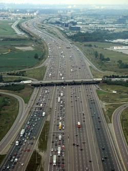
ทางหลวงควบคุมการเข้าออกอาจมีสองเลน ซึ่งรู้จักกันในชื่อทางด่วนสองเลนมักจะไม่มีเกาะกลาง มักสร้างขึ้นเมื่อปริมาณการจราจรต่ำ (แต่อาจได้รับการปรับปรุงในภายหลัง) หรือเนื่องจากพื้นที่จำกัด หรือเนื่องจากงบประมาณน้อย อาจออกแบบมาเพื่อให้ง่ายต่อการแปลงเป็นเลนเดียวของทางด่วนสี่เลน และอาจมีการจัดหาพื้นที่ไว้แล้ว (ตัวอย่างเช่น ทางด่วนMountain Parkwayในรัฐเคนตักกี้ ตะวันออกส่วนใหญ่ เป็นสองเลน แต่ได้เริ่มดำเนินการเพื่อขยายเป็นสี่เลนทั้งหมดแล้ว) ทางหลวงเหล่านี้มักถูกเรียกว่า " ถนน ซูเปอร์ทู " ถนนหลายสายดังกล่าวมีชื่อเสียงในด้านอัตราการเกิดอุบัติเหตุร้ายแรงสูง ซึ่งเป็นผลมาจากการออกแบบที่คำนึงถึงระยะการมองเห็นที่สั้น (เพียงพอสำหรับทางด่วนที่ไม่มีรถสวนทาง แต่ไม่เพียงพอสำหรับการใช้งานเป็นถนนสองเลนที่มีรถสวนทางเป็นเวลาหลายปี) ตัวอย่างของ "ทางหลวงสู่ขุมนรก" ดังกล่าวคือเส้นทางยุโรป E4จากGävleไปยังAxmartavlanประเทศสวีเดน อัตราการเกิดอุบัติเหตุที่มีผู้ได้รับบาดเจ็บสาหัสบนถนนสายนั้น (และถนนที่คล้ายกัน) ที่สูงยังคงดำเนินต่อไปจนกระทั่งมีการติดตั้งแผงกั้นกลางถนน ซึ่งเปลี่ยนอุบัติเหตุร้ายแรงให้กลายเป็นอุบัติเหตุที่ไม่ร้ายแรง มิฉะนั้น โดยทั่วไปแล้วทางด่วนจะมีอย่างน้อยสองเลนในแต่ละทิศทาง บางแห่งที่มีการจราจรหนาแน่นอาจมีมากถึง 16 เลนหรือมากกว่านั้น [ e ]
ใน เมือง ซานดิเอโก รัฐแคลิฟอร์เนียทางหลวงหมายเลข 5 ( Interstate 5 ) มีระบบช่องทางด่วนและช่องทางปกติที่คล้ายกัน โดยมีช่องทางกว้างสูงสุด 21 ช่องทาง ในช่วงระยะทาง 2 ไมล์ (3.2 กิโลเมตร) ระหว่างทางหลวงหมายเลข 805 (Interstate 805 ) และทางหลวงรัฐแคลิฟอร์เนียหมายเลข 56 (California State Route 56 ) ส่วนในเมืองมิสซิสซอกา รัฐออนแทรีโอทางหลวงหมายเลข 401 ( Highway 401 ) ใช้ช่องทางด่วนและช่องทางรวม (collector-express lanes)รวมทั้งหมด 18 ช่องทาง บริเวณทางแยกกับ ทางหลวง หมายเลข403/410และทางหลวงหมายเลข 427
ทางด่วนที่กว้างเหล่านี้อาจใช้ช่องทางเชื่อมต่อและช่องทางด่วน แยกต่างหาก เพื่อแยกการจราจรที่ผ่านไปมาออกจากการจราจรในท้องถิ่น หรือช่องทางสำหรับรถยนต์ที่มีผู้โดยสารหลายคนโดยเฉพาะ อาจเป็นข้อจำกัดพิเศษในช่องทางในสุดหรือเป็นถนนแยกต่างหาก เพื่อส่งเสริมการใช้รถร่วมกันช่องทาง HOVเหล่านี้หรือถนนที่เปิดให้รถทุกคันใช้ได้ อาจเป็นช่องทางที่เปลี่ยนทิศทางได้เพื่อเพิ่มความจุในทิศทางที่มีการจราจรหนาแน่น และเปลี่ยนทิศทางก่อนที่การจราจรจะเปลี่ยนทาง บางครั้งถนนเชื่อมต่อ/กระจายรถ ซึ่งเป็นช่องทางท้องถิ่นที่สั้นกว่า จะย้ายการสลับเลนระหว่างทางแยกที่อยู่ใกล้กันไปยังถนนแยกต่างหาก หรืออาจกำจัดไปเลยก็ได้
ในบางส่วนของโลก โดยเฉพาะบางส่วนของสหรัฐอเมริกาถนนด้านข้าง ถือเป็นส่วนสำคัญของระบบทางด่วน ถนนพื้นผิวขนานเหล่า นี้ทำหน้าที่เป็นทางเชื่อมระหว่างการจราจรความเร็วสูงที่วิ่งผ่านกับการจราจรในท้องถิ่น ทางลาดเชื่อมต่อที่ถี่ช่วยให้สามารถเข้าถึงระหว่างทางด่วนและถนนด้านข้าง ซึ่งในทางกลับกันก็ช่วยให้สามารถเข้าถึงถนนและธุรกิจในท้องถิ่นได้โดยตรง[ 25 ]
ยกเว้นบนทางด่วนสองเลนบางแห่ง (และพบได้น้อยมากบนทางด่วนที่กว้างกว่า) เกาะกลางถนนจะแยกทิศทางการจราจรที่สวนทางกัน แถบนี้อาจเป็นเพียงพื้นที่หญ้า หรืออาจมีแผงกั้นกันชนเช่น " แผงกั้นเจอร์ซีย์ " หรือ "กำแพงสูงออนแทรีโอ" เพื่อป้องกัน การ ชนประสานงา[ 26 ]บนทางด่วนบางแห่ง ช่องทางเดินรถทั้งสองช่องสร้างขึ้นบนแนวที่แตกต่างกัน ซึ่งอาจทำเพื่อใช้ประโยชน์จากทางเดินรถที่มีอยู่แล้วในพื้นที่ภูเขา หรือเพื่อให้มีทางเดินรถที่แคบลงผ่านพื้นที่เมืองที่ มีความหนาแน่นสูง
การควบคุมการเข้าถึง
การควบคุมการเข้าถึงเกี่ยวข้องกับสถานะทางกฎหมายที่จำกัดประเภทของยานพาหนะที่สามารถใช้ทางหลวงได้ รวมถึงการออกแบบถนนที่จำกัดจุดที่ยานพาหนะเหล่านั้นสามารถเข้าถึงได้
ถนนสายหลักมักมีการควบคุมการเข้าออกบางส่วนหมายความว่าถนนสายรองจะตัดกับถนนสายหลักในระดับเดียวกัน แทนที่จะใช้ทางแยกต่างระดับ แต่ทางเข้าบ้านอาจไม่ได้เชื่อมต่อกับถนนสายหลักโดยตรง และผู้ขับขี่ต้องใช้ถนนที่ตัดกันเพื่อเข้าถึงที่ดินที่อยู่ติดกัน บริเวณทางแยกของถนนสายหลักที่มีถนนสายรองค่อนข้างเงียบ การจราจรจะถูกควบคุมโดยหลักๆ ด้วยป้ายหยุดสองทาง ซึ่งไม่ก่อให้เกิดการหยุดชะงักอย่างมีนัยสำคัญต่อการจราจรบนทางหลวงสายหลักวงเวียนมักใช้ในทางแยกที่มีการจราจรหนาแน่นในยุโรป เพราะช่วยลดการหยุดชะงักของการจราจร ในขณะที่สัญญาณไฟจราจรที่สร้างการรบกวนการจราจรมากกว่ายังคงเป็นที่นิยมในอเมริกาเหนือ อาจมีทางแยกต่างระดับกับถนนสายหลักอื่นๆ เป็นครั้งคราว ตัวอย่างเช่น ทางหลวงหมายเลข23 ของสหรัฐฯระหว่างจุดสิ้นสุดด้านตะวันออกของทางหลวงหมายเลข 15 และ เมืองเดลาแวร์ รัฐโอไฮโอรวมถึงทางหลวงหมายเลข 15 ระหว่างจุดสิ้นสุดด้านตะวันออกและทางหลวงหมายเลข 75 , ทางหลวงหมายเลข 30 ของสหรัฐฯ , ทางหลวงหมายเลข 29/33ของสหรัฐฯและ ทางหลวง หมายเลข 35 ของสหรัฐฯ ใน รัฐ โอไฮโอตอนตะวันตกและตอนกลาง ถนนประเภทนี้บางครั้งเรียกว่าทางด่วน
การเข้าถึงทางด่วนโดยไม่ใช้ยานยนต์
โดยทั่วไปแล้วทางด่วนจะจำกัดเฉพาะยานยนต์ที่มีกำลังหรือน้ำหนักขั้นต่ำเท่านั้น ป้ายอาจห้ามจักรยาน คนเดินเท้าและผู้ขี่ม้าและกำหนดความเร็วขั้นต่ำ การจราจรที่ไม่ใช้เครื่องยนต์สามารถใช้สิ่งอำนวยความสะดวกภายในเขตทางเดียวกันได้ เช่นทางเท้า ที่ สร้าง ขึ้นตาม สะพานมาตรฐานทางด่วนและทางเดินอเนกประสงค์ที่อยู่ติดกับทางด่วน เช่นเส้นทางซันโคสต์ เทรล ตาม แนว ซันโคสต์พาร์คเวย์ในฟลอริดา

ในบางเขตอำนาจศาลของสหรัฐอเมริกา โดยเฉพาะอย่างยิ่งในกรณีที่ทางด่วนเข้ามาแทนที่ถนนที่มีอยู่เดิมการเข้าถึงทางด่วนโดยไม่ใช้ยานยนต์ได้รับอนุญาต รัฐต่างๆ ในสหรัฐอเมริกามีกฎหมายที่แตกต่างกัน การปั่นจักรยานบนทางด่วนในรัฐแอริโซนาอาจถูกห้ามเฉพาะในกรณีที่มีเส้นทางอื่นที่ถือว่าดีเท่ากันหรือดีกว่าสำหรับการปั่นจักรยาน[ 27 ] รัฐ ไวโอมิง ซึ่งเป็นรัฐที่มีประชากรหนาแน่นน้อยที่สุดเป็นอันดับสอง อนุญาตให้ปั่นจักรยานบนทางด่วนทุกสาย รัฐโอเรกอนอนุญาตให้ใช้จักรยานได้ ยกเว้นบนทางด่วนในเมืองบางแห่งในพอร์ตแลนด์และเมดฟอร์ด[ 28 ]
ในประเทศต่างๆ เช่นสหราชอาณาจักรทางหลวงใหม่ต้องอาศัยพระราชบัญญัติจากรัฐสภาเพื่อให้แน่ใจว่ามีการจำกัดสิทธิ์ในการใช้ทาง เนื่องจากหากยกระดับถนนที่มีอยู่ ("ทางหลวงหลวงของกษัตริย์") ให้เป็นทางหลวงเต็มรูปแบบ จะทำให้สิทธิ์ในการเข้าถึงของกลุ่มบางกลุ่ม เช่น คนเดินเท้า นักปั่นจักรยาน และรถที่เคลื่อนที่ช้า หมดไป ถนนที่มีการควบคุมการเข้าถึงหลายแห่งจึงไม่ใช่ทางหลวงเต็มรูปแบบ[ 29 ]ในบางกรณี ทางหลวงจะเชื่อมต่อกันด้วยถนนช่วงสั้นๆ ซึ่งไม่สามารถใช้สิทธิ์ในการใช้ทางอื่นได้ เช่น สะพานดาร์ตฟอร์ด (ทางข้ามสาธารณะที่อยู่ไกลที่สุดทางตอนล่างของแม่น้ำเทมส์ ) หรือในกรณีที่ไม่คุ้มค่าที่จะสร้างทางหลวงขนานไปกับถนนที่มีอยู่ เช่น คัมเบอร์แลนด์แกปเดิม ทางหลวงA1เป็นตัวอย่างที่ดีของการปรับปรุงทีละส่วนเพื่อให้ได้มาตรฐานมอเตอร์เวย์ โดย ณ เดือนมกราคม 2556 เส้นทางยาว 639 กิโลเมตร (397 ไมล์) มีมอเตอร์เวย์ (กำหนดให้เป็น A1(M)) จำนวน 5 ช่วง และลดลงเหลือ 4 ช่วงในเดือนมีนาคม 2561 เมื่อการก่อสร้าง A1(M) ในน อร์ทยอร์กเชียร์ เสร็จสมบูรณ์
เทคนิคการก่อสร้าง

วิธีการสร้างทางด่วนที่พบได้บ่อยที่สุดคือการสร้างขึ้นใหม่ตั้งแต่ต้นหลังจากที่สิ่งกีดขวาง เช่น ป่าไม้หรืออาคารต่างๆ ถูกกำจัดออกไป บางครั้งวิธีการนี้ทำให้พื้นที่ทำการเกษตรลดลง แต่ก็มีการพัฒนาวิธีการอื่นๆ ขึ้นมาด้วยเหตุผลทางเศรษฐกิจ สังคม และแม้กระทั่งสิ่งแวดล้อม
บางครั้งมีการสร้างทางด่วนเต็มรูปแบบโดยการเปลี่ยนทางด่วนระดับพื้นดิน หรือโดยการแทนที่ทางแยกระดับพื้นดินด้วยสะพานลอย อย่างไรก็ตาม ในสหรัฐอเมริกา ทางแยกระดับพื้นดินใดๆ ที่สิ้นสุดทางด่วนมักจะยังคงเป็นทางแยกระดับพื้นดินอยู่ บ่อยครั้งที่ทางด่วนหรือทางด่วนสองเลนที่ไม่มีเกาะกลาง จะถูกเปลี่ยนโดยการสร้างทางคู่ขนาน และเว้นเกาะกลางไว้ระหว่างสองทิศทางการจราจร เลนการจราจรด้านเกาะกลางของทางคู่ขนานสองเลนเดิมจะกลายเป็นเลนแซง
เทคนิคอื่นๆ ได้แก่ การสร้างช่องทางเดินรถใหม่ด้านข้างทางหลวงที่มีช่องทางแบ่ง ซึ่งมีทางเข้าออกส่วนบุคคลจำนวนมากอยู่ด้านหนึ่ง และบางครั้งก็มีทางเข้าออกบ้านที่ยาวอยู่ด้านตรงข้าม เนื่องจากมีการใช้สิทธิ์ในการขยายช่องทางเดินรถ โดยเฉพาะในพื้นที่ชนบท
เมื่อ มีการเพิ่มช่องทางจราจร ที่สามบางครั้งอาจทำให้ช่องทางจราจรหลักเบี่ยงเบนไป 20–60 เมตร (50–200 ฟุต) (หรืออาจมากกว่านั้นขึ้นอยู่กับพื้นที่ว่าง) เพื่อรักษาสิทธิ์ในการเข้าถึงส่วนตัวในด้านหนึ่งที่สะดวกกว่าอีกด้านหนึ่ง วิธีการอื่น ๆ ได้แก่ การสร้างทางเข้าออกสำหรับบริการซึ่งจะช่วยลดความยาวของทางเข้าออกเดิม (โดยทั่วไปจะลดความยาวไม่เกิน 100 เมตร (330 ฟุต))
จุดเชื่อมต่อและทางเข้าออก


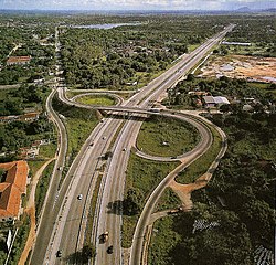
ทางแยกหรือจุดเชื่อมต่อ คือรูปแบบทางหลวงที่อนุญาตให้รถจากทางหลวงที่มีการควบคุมการเข้าออกเส้นหนึ่งไปยังอีกเส้นหนึ่ง และในทางกลับกัน ในขณะที่จุดเข้าออก คือรูปแบบทางหลวงที่รถจากถนนสายรองหรือถนนท้องถิ่นสามารถเข้าสู่ทางหลวงที่มีการควบคุมการเข้าออกได้ บางประเทศ เช่น สหราชอาณาจักรไม่แยกความแตกต่างระหว่างสองอย่างนี้ แต่บางประเทศก็แยกความแตกต่าง ตัวอย่างเช่นเยอรมนีใช้คำว่าKreuz ("กากบาท") หรือDreieck ("สามเหลี่ยม") สำหรับอย่างแรก และAusfahrt ("ทางออก") สำหรับอย่างหลัง ในทุกกรณี ถนนเส้นหนึ่งตัดกับอีกเส้นหนึ่งโดยใช้สะพานหรืออุโมงค์ ไม่ใช่การตัดกันแบบระดับพื้นดิน
ถนนเชื่อมต่อหรือทางลาดที่เชื่อมถนนสองสายเข้าด้วยกัน สามารถมีรูปแบบได้หลากหลาย รูปแบบที่แท้จริงนั้นขึ้นอยู่กับหลายปัจจัย รวมถึงลักษณะภูมิประเทศในท้องถิ่น ความหนาแน่นของการจราจร ต้นทุนที่ดิน ต้นทุนการก่อสร้าง ประเภทของถนน เป็นต้น ในบางพื้นที่ เลนเชื่อมต่อ/กระจายการจราจรเป็นเรื่องปกติ โดยเฉพาะอย่างยิ่งสำหรับทางแยกต่างระดับแบบใบไม้สี่แฉกในขณะที่ในบางพื้นที่ เช่น สหราชอาณาจักร ซึ่งทางแยกต่างระดับแบบวงเวียนเป็นเรื่องปกติ เลนเชื่อมต่อ/กระจายการจราจรจึงไม่ค่อยพบเห็น
โดยทั่วไปแล้วมอเตอร์เวย์ในยุโรปจะแยกความแตกต่างระหว่างทางออกและทางแยก ทางออกคือทางที่ออกจากระบบมอเตอร์เวย์ ในขณะที่ทางแยกคือจุดตัดระหว่างมอเตอร์เวย์หรือจุดแยก/รวมของมอเตอร์เวย์สองสาย กฎของมอเตอร์เวย์จะสิ้นสุดที่ทางออก แต่ไม่สิ้นสุดที่ทางแยก อย่างไรก็ตาม บนสะพานบางแห่ง มอเตอร์เวย์จะสิ้นสุดชั่วคราวระหว่างทางออกสองทางที่ใกล้กับสะพาน (หรืออุโมงค์) มากที่สุด และยังคงเป็นถนนสองเลน ต่อไป โดยไม่เปลี่ยนแปลงลักษณะ ที่ปรากฏ เพื่อให้รถที่วิ่งช้ากว่ามีโอกาสใช้สะพานได้สะพานควีนเอลิซาเบธที่ 2 / อุโมงค์ดาร์ตฟอร์ดบนลอนดอนออร์บิทัลเป็นตัวอย่างหนึ่งของเรื่องนี้ ลอนดอนออร์บิทัล หรือ M25 เป็นมอเตอร์เวย์ที่ล้อมรอบกรุงลอนดอนแต่ที่ จุดข้าม แม่น้ำเทมส์ สุดท้าย ก่อนถึงปากแม่น้ำ กฎของมอเตอร์เวย์จะไม่ใช้บังคับ (ที่จุดข้ามนี้ ลอนดอนออร์บิทัลจะใช้ชื่อ A282 แทน)
ตัวอย่างของ จุดเชื่อมต่อประเภททั่วไปบางส่วนแสดงไว้ด้านล่าง: [ 30 ] [ 31 ] [ 32 ]
 โครงสร้างสี่ระดับ : ใช้เป็นจุดเชื่อมต่อหลัก โดยปกติจะใช้กับจุดเชื่อมต่อทางด่วน
 ทางแยกวงเวียน : พบเห็นได้ทั่วไปในสหราชอาณาจักร ทั้งในฐานะทางแยกหรือทางออก
 สี่แยกรูปใบโคลเวอร์ : ใช้เป็นหลักในการเชื่อมต่อ
 ทางแยกต่างระดับ แบบพาร์โคล (รูปใบโคลเวอร์บางส่วน): มักใช้เชื่อมต่อถนนสายรองกับทางแยก
 ทางแยกรูปแตร: ทางแยกรูปตัว "T" บนมอเตอร์เวย์ ใช้ในกรณีที่ทางแยกนั้นเป็นจุดสิ้นสุดของถนนเส้นใดเส้นหนึ่งจากสองเส้น นอกจากนี้ยังพบได้ทั่วไปบนทางด่วนเก็บค่าผ่านทาง เนื่องจากใช้เพียงด่านเก็บค่าผ่านทางเดียว
 ทางด่วนแยกหรือรวมเลน; หลักการพื้นฐานคล้ายกับทางแยกรูปตัวที
 ทางแยกต่างระดับแบบจุดเดียวในเขตเมืองหรือ SPUI (Single-point Urban Interchange) ใช้ในเขตเมืองที่มีความหนาแน่นสูงเพื่อลดพื้นที่การใช้ที่ดินของทางแยก
 ทางแยกต่างระดับรูปเพชรแบบแยกออก ; ออกแบบมาเพื่อปรับปรุงการไหลเวียนของจราจรและความปลอดภัยโดยลดจำนวนการเลี้ยวที่ต้องตัดผ่านเลนจราจรที่สวนทางกัน


ความปลอดภัย
มีความแตกต่างมากมายระหว่างประเทศต่างๆ ในด้านภูมิศาสตร์ เศรษฐกิจ การเติบโตของการจราจร ขนาดของระบบทางหลวง ระดับความเป็นเมือง และการใช้ยานยนต์ เป็นต้น ซึ่งทั้งหมดนี้จำเป็นต้องนำมาพิจารณาเมื่อทำการเปรียบเทียบ[ 33 ]ตามเอกสารของสหภาพยุโรปบางฉบับ ความก้าวหน้าด้านความปลอดภัยบนมอเตอร์เวย์เป็นผลมาจากการเปลี่ยนแปลงหลายประการ รวมถึงความปลอดภัยของโครงสร้างพื้นฐานและพฤติกรรมของผู้ใช้ถนน (ความเร็วหรือการใช้เข็มขัดนิรภัย) ในขณะที่เรื่องอื่นๆ เช่น ความปลอดภัยของยานพาหนะและรูปแบบการเคลื่อนที่ส่งผลกระทบที่ยังไม่ได้วัดปริมาณ[ 34 ]
ทางหลวงและถนนอื่นๆ
ทางหลวงมอเตอร์เวย์ได้รับการออกแบบให้มีความปลอดภัยที่สุด แม้ว่าจะคิดเป็นสัดส่วนมากกว่าหนึ่งในสี่ของระยะทางขับขี่ทั้งหมด แต่กลับมีส่วนทำให้เกิดการเสียชีวิตบนท้องถนนในยุโรปเพียง 8% ในปี 2549 [ 2 ]สถาบันวิจัยทางหลวงแห่งสหพันธรัฐเยอรมนีได้จัดทำ สถิติฐาน ข้อมูลอุบัติเหตุและการจราจรทางถนนระหว่างประเทศ (IRTAD) สำหรับปี 2553 โดยเปรียบเทียบอัตราการเสียชีวิตโดยรวมกับอัตราการเสียชีวิตบนทางหลวงมอเตอร์เวย์ (โดยไม่คำนึงถึงความหนาแน่นของการจราจร)
| ประเทศ | ทุกเส้นทาง | ทางหลวง | |
|---|---|---|---|
| 2010 | 2010 | 2020 | |
| ออสเตรีย | 7.32 | 2.15 | 1.28 |
| เบลเยียม | 8.51 | 2.87 | |
| สาธารณรัฐเช็ก | 16.22 | 3.38 | 2.53 |
| เดนมาร์ก | 5.65 | 1.92 | 0.91 |
| ฟินแลนด์ | 5.05 | 0.61 | 1.24 |
| ฝรั่งเศส | 7.12 | 1.79 | 1.56 |
| เยอรมนี | 5.18 | 1.98 | 1.48 |
| สโลวีเนีย | 7.74 | 3.77 | 1.01 |
| สวิตเซอร์แลนด์ | 5.25 | 1.04 | 0.85 |
| สหรัฐอเมริกา | 6.87 | 3.62 | 4.19 (เบื้องต้น) |
| แหล่งที่มา: IRTAD-BAST-2020 [ 35 ] [ 36 ] | |||
เครือข่าย ทางด่วนของเยอรมนีแสดงให้เห็นถึงการแลกเปลี่ยนด้านความปลอดภัยของทางหลวงที่มีการควบคุมการเข้าถึง อัตราการเกิดอุบัติเหตุที่ทำให้เกิดการบาดเจ็บนั้นต่ำมากบนทางด่วน[ 37 ]ในขณะที่มีผู้เสียชีวิต 22 คนต่ออุบัติเหตุที่ทำให้เกิดการบาดเจ็บ 1,000 ครั้ง แม้ว่าทางด่วนจะมีอัตราการเสียชีวิตต่ำกว่า 29 คนต่ออุบัติเหตุที่ทำให้เกิดการบาดเจ็บ 1,000 ครั้งบนถนนชนบททั่วไป แต่ก็ยังสูงกว่าความเสี่ยงบนถนนในเมือง ความเร็วบนถนนชนบทและทางด่วนสูงกว่าถนนในเมือง ซึ่งเพิ่มศักยภาพความรุนแรงของการเกิดอุบัติเหตุ[ 38 ]
ตามข้อมูลของ ETSC ทางหลวงของเยอรมนีที่ไม่มีการจำกัดความเร็ว แต่มีคำแนะนำให้ขับที่ 130 กม./ชม. (81 ไมล์/ชม.) มีอันตรายมากกว่าทางหลวงที่มีการจำกัดความเร็วถึง 25% [ 39 ]
เยอรมนียังได้นำข้อจำกัดความเร็ว 130 กม./ชม. (81 ไมล์/ชม.) มาใช้ในบางช่วงของมอเตอร์เวย์ที่ไม่มีการจำกัดความเร็วมาก่อน ซึ่งส่งผลให้จำนวนผู้เสียชีวิตลดลงตั้งแต่ 20% ถึง 50% ในช่วงดังกล่าว[ 40 ]
สาเหตุของการเกิดอุบัติเหตุ
ความเร็วในยุโรปถือเป็นหนึ่งในปัจจัยหลักที่ทำให้เกิดอุบัติเหตุ ประเทศบางประเทศ เช่น ฝรั่งเศสและสวิตเซอร์แลนด์ สามารถลดจำนวนผู้เสียชีวิตลงได้ด้วยการตรวจสอบความเร็วที่ดีขึ้น เครื่องมือที่ใช้ในการตรวจสอบความเร็วอาจได้แก่ การเพิ่มความหนาแน่นของการจราจร การบังคับใช้กฎหมายความเร็วที่เข้มงวดขึ้น และกฎระเบียบที่เข้มงวดมากขึ้นซึ่งนำไปสู่การเพิกถอนใบอนุญาตขับขี่ กล้องตรวจจับความเร็ว การตัดแต้ม และค่าปรับที่สูงขึ้น บางประเทศใช้กล้องตรวจจับเวลาต่อระยะทางอัตโนมัติ (หรือที่เรียกว่าการควบคุมส่วนต่างๆ ) เพื่อจัดการความเร็ว[ 34 ]
ความเหนื่อยล้าถือเป็นปัจจัยเสี่ยงที่เฉพาะเจาะจงกับถนนที่น่าเบื่อ เช่น ทางหลวง แม้ว่าข้อมูลดังกล่าวจะไม่ได้ถูกตรวจสอบ/บันทึกในหลายประเทศก็ตาม[ 34 ]จากข้อมูลของVinci Autoroutesพบว่าหนึ่งในสามของอุบัติเหตุบนทางหลวงของฝรั่งเศสเกิดจากการขับขี่ขณะง่วงนอน[ 41 ]
ร้อยละ 23 ของผู้เสียชีวิตบนมอเตอร์เวย์ของฝรั่งเศสไม่ได้คาดเข็มขัดนิรภัย ในขณะที่ร้อยละ 98 ของผู้โดยสารที่นั่งด้านหน้าและร้อยละ 87 ของผู้โดยสารที่นั่งด้านหลังคาดเข็มขัดนิรภัย[ 34 ]
แนวโน้มการเสียชีวิต
แม้ว่าผลลัพธ์ด้านความปลอดภัยจะไม่เปลี่ยนแปลงมากนักในแต่ละปี แต่ในยุโรปก็มีการเปลี่ยนแปลงบางอย่างเกิดขึ้น: อัตราการเสียชีวิตบนทางหลวงลดลง 41% ในช่วงทศวรรษ 2006–2015 แต่กลับเพิ่มขึ้น 10% ระหว่างปี 2014 และ 2015 อย่างไรก็ตาม เมื่อพิจารณาความยาวของเครือข่ายทางหลวงเพื่อสะท้อนถึงความเสี่ยง ข้อมูลแสดงให้เห็นว่าอัตราการเสียชีวิตต่อพันกิโลเมตรลดลงครึ่งหนึ่งระหว่างปี 2006 และ 2015 [ 42 ]
| ปี | ผู้เสียชีวิต | อัตราต่อประชากรหนึ่งล้านคน | อัตราต่อ1,000 กิโลเมตรของทางหลวง |
|---|---|---|---|
| 2006 | 3,485 | 7.1 | 54.4 |
| 2010 | 2,329 | 4.7 | 32.9 |
| 2015 | 2,048 | 4.1 | 27.3 |
| แหล่งที่มา: ข้อเท็จจริงพื้นฐานด้านความปลอดภัยทางจราจร 2017 ทางหลวง[ 42 ] | |||
ผลกระทบจากค่าผ่านทาง
การศึกษา ของมหาวิทยาลัยบาร์เซโลนาชี้ให้เห็นว่า หาก มี การเก็บค่าผ่านทางบนทางหลวงที่มีการควบคุมการเข้าออก ผู้ขับขี่อาจมองหาเส้นทางอื่นเพื่อหลีกเลี่ยงการจ่ายค่าผ่านทาง ซึ่งอาจส่งผลให้ความปลอดภัยบนถนนที่ไม่ได้ออกแบบมาสำหรับการจราจรหนาแน่นลดลง[ 43 ]
ความปลอดภัยในเขตเมือง
ในสหราชอาณาจักร มีการศึกษาน้อยมากเกี่ยวกับผลกระทบของอุบัติเหตุจราจรทางถนนจากมอเตอร์เวย์ในเมืองที่มีอยู่และมอเตอร์เวย์ในเมืองใหม่[ 44 ]โดยเฉพาะอย่างยิ่ง มอเตอร์เวย์ในเมืองใหม่ไม่ได้ทำให้อุบัติเหตุจราจรลดลง
ในประเทศอิตาลี การศึกษาที่ดำเนินการบนทางหลวงในเมืองA56 Tangenziale di Napoliแสดงให้เห็นว่าการลดความเร็วส่งผลให้จำนวนอุบัติเหตุลดลง[ 45 ]
ในเมืองมาร์เซย์ประเทศฝรั่งเศส ตั้งแต่เดือนมิถุนายน พ.ศ. 2552 ถึงพฤษภาคม พ.ศ. 2553 CEREMA ซึ่งเป็นศูนย์วิจัยด้านความเสี่ยง การเคลื่อนที่ และสิ่งแวดล้อมของฝรั่งเศส ได้ทำการศึกษาเกี่ยวกับMariusซึ่งเป็นเครือข่ายมอเตอร์เวย์ในเมือง การศึกษานี้ได้สร้างความเชื่อมโยงระหว่างอุบัติเหตุและตัวแปรการจราจร: [ 46 ]
- สำหรับอุบัติเหตุรถยนต์คันเดียว ความเร็วเฉลี่ย 6 นาทีในเลนเร็ว และระยะห่างระหว่างรถ (ในทุกเลน)
- สำหรับอุบัติเหตุที่มีรถหลายคัน จะต้องพิจารณาจำนวนผู้โดยสาร และระยะห่างระหว่างรถ (สำหรับเลนกลาง)
เครือข่ายถนนมาริอุสซึ่งมีความยาว 150 กิโลเมตร (93 ไมล์) มีอุบัติเหตุที่ทำให้บาดเจ็บหรือเสียชีวิต 292 ครั้ง ต่อระยะทางการขับขี่ 1.5 พันล้านกิโลเมตร หรือคิดเป็นอุบัติเหตุที่ทำให้บาดเจ็บหรือเสียชีวิต 189 ครั้ง ต่อระยะทางการขับขี่ 1 พันล้านกิโลเมตร
บางประเทศในยุโรปได้ปรับปรุงความปลอดภัยของทางหลวงในเขตเมือง โดยใช้มาตรการต่างๆ เพื่อจัดการการจราจรอย่างมีประสิทธิภาพตามปริมาณ ความเร็ว และอุบัติเหตุที่เปลี่ยนแปลงไป ซึ่งรวมถึง:
- การจำกัดความเร็วแบบแปรผัน การควบคุมเส้นทาง และการประสานความเร็ว
- การวิ่งบนไหล่ทางพร้อมพื้นที่หลบภัยฉุกเฉิน
- การแจ้งเตือนคิวและการส่งข้อความตัวแปร
- การตรวจสอบการจราจรตลอด 24 ชั่วโมง 7 วันต่อสัปดาห์ ด้วยกล้องและ/หรือเซ็นเซอร์ฝังพื้นถนน (เพื่อตรวจจับเหตุการณ์และระบุเวลาที่ควรลดความเร็ว)
- การจัดการเหตุการณ์
- การบังคับใช้โดยอัตโนมัติ
- อัลกอริทึมเฉพาะสำหรับการวิ่งบนไหล่ทางชั่วคราว การจำกัดความเร็วแบบแปรผัน และ/หรือการตรวจจับและจัดการอุบัติเหตุ
- การวัดปริมาณทางลาด (ฟังก์ชันที่ประสานงานหรือเป็นอิสระ) [ 47 ]
ในปี พ.ศ. 2537 สันนิษฐานว่าการให้แสงสว่างแก่ทางหลวงในเมืองจะช่วยเพิ่มความปลอดภัยได้มากกว่าทางหลวงที่ไม่มีแสงสว่าง[ 48 ]
ในแคลิฟอร์เนียในปี 2544 การศึกษาวิจัยได้ระบุความสัมพันธ์บางประการระหว่างอุบัติเหตุบนทางด่วนในเมือง การจราจร สภาพอากาศ และสภาพแสงสว่าง: [ 49 ]
- มันแสดงให้เห็นถึงความแตกต่างระหว่างทางหลวงแห้งในเวลากลางวันและทางหลวงเปียกในเวลากลางคืน
- งานวิจัยนี้ระบุว่า อุบัติเหตุในเลนซ้ายมักเกิดจากปริมาณการจราจร ในขณะที่อุบัติเหตุในเลนขวาเกี่ยวข้องกับความเร็วที่แตกต่างกันในเลนข้างเคียงมากกว่า (ในแคลิฟอร์เนีย ผู้คนขับรถในเลนขวา ยกเว้นเมื่อต้องการแซง)
ผลกระทบต่อสิ่งแวดล้อม
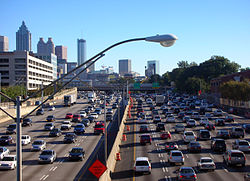


ทางหลวงที่มีการควบคุมการเข้าออกถูกสร้างขึ้นทั้งระหว่างเมืองใหญ่และภายในเมืองใหญ่ ส่งผลให้เกิด การพัฒนา ชานเมือง ที่แผ่ขยายออก ไปใกล้กับเมืองสมัยใหม่ส่วนใหญ่ ทางหลวงเหล่านี้ถูกวิพากษ์วิจารณ์อย่างหนักในเรื่องเสียงดัง[ 50 ]มลพิษ และการเปลี่ยนแปลงทางเศรษฐกิจที่เกิดขึ้น[ 51 ]นอกจากนี้ ผู้ขับขี่ยังวิพากษ์วิจารณ์ถึงความไม่มีประสิทธิภาพในการจัดการการจราจรในช่วงชั่วโมงเร่งด่วน[ 52 ] [ 53 ] [ 54 ]
ทางหลวงในชนบทมักเปิดพื้นที่กว้างใหญ่ให้กับการพัฒนาเศรษฐกิจและบริการของเทศบาล ซึ่งโดยทั่วไปแล้วจะทำให้มูลค่าทรัพย์สินสูงขึ้น ในทางตรงกันข้าม ทางหลวงระดับพื้นดินในเขตเมืองมักเป็นแหล่งที่มาของการลดลงของมูลค่าทรัพย์สิน ซึ่งส่งผลให้เกิดความเสื่อมโทรมของเมืองแม้จะมีสะพานลอยและอุโมงค์ลอดใต้ถนน แต่ชุมชนก็ยังคงถูกแบ่งแยก โดยเฉพาะอย่างยิ่งชุมชนที่ยากจนซึ่งผู้อยู่อาศัยมีโอกาสน้อยที่จะเป็นเจ้าของรถยนต์ หรือไม่มีอิทธิพลทางการเมืองและเศรษฐกิจที่จะต่อต้านความพยายามในการก่อสร้าง[ 55 ]ตั้งแต่ต้นทศวรรษ 1970 รัฐสภาสหรัฐฯได้ระบุว่าทางด่วนและทางหลวงในเมืองอื่นๆ เป็นสาเหตุหลักของการได้รับเสียงรบกวนของประชากรในสหรัฐฯ[ 56 ]ต่อมาได้มีการพัฒนารูปแบบคอมพิวเตอร์เพื่อวิเคราะห์เสียงรบกวนจากทางด่วนและช่วยในการออกแบบเพื่อช่วยลดเสียงรบกวนให้น้อย ที่สุด [ 57 ]
บางเมืองได้นำ นโยบาย การรื้อถอนทางด่วน มาใช้ โดยการทุบทางด่วนและเปลี่ยนพื้นที่เป็นถนนใหญ่หรือสวนสาธารณะ ตัวอย่างเช่น ในกรุงโซล ( คลองชองกเยชอน ), พอร์ตแลนด์ ( ถนน ฮาร์เบอร์ไดรฟ์ ), นครนิวยอร์ก ( ทางด่วนยกระดับเวสต์ ไซด์ ), บอสตัน ( ถนนเซ็นทรัลอาร์เทอรี ), ซานฟรานซิสโก ( ทางด่วนเอ็มบาร์คาเดโร ), ซีแอตเติล ( สะพานลอยอะแลสกันเวย์ ) และมิลวอกี ( ทางด่วนพาร์คอีสต์ )
ทางเลือกหนึ่งนอกเหนือจากการสร้างทางด่วนบนพื้นดิน คือการสร้างทางด่วนใต้ดินในเมืองโดยใช้เทคโนโลยีการขุดอุโมงค์ วิธีการนี้ได้ถูกนำมาใช้ในมาดริดและปรากรวมถึงเมืองซิดนีย์ (ซึ่งมีทางด่วนดังกล่าว 5 สาย) บริสเบน (ซึ่งมี 3 สาย) และเมลเบิร์น (ซึ่งมี 2 สาย) ในออสเตรเลียข้อดีของวิธีนี้คือไม่ทำให้เกิดถนนบนพื้นดินที่มีการจราจรหนาแน่น และในกรณีของทางด่วนอีสต์ลิงก์ ในเมลเบิร์น ยังช่วยป้องกันการทำลายพื้นที่ที่มีความอ่อนไหวทางนิเวศวิทยาอีกด้วย
เมืองอื่นๆ ในออสเตรเลียก็ประสบปัญหาคล้ายๆ กัน (การขาดแคลนที่ดิน ราคาซื้อบ้าน ปัญหาด้านสุนทรียภาพ และการต่อต้านจากชุมชน) บริสเบนซึ่งต้องรับมือกับข้อจำกัดทางกายภาพ ( แม่น้ำบริสเบน ) และการเพิ่มขึ้นของประชากรอย่างรวดเร็ว ได้นำเอาทางด่วนใต้ดินมาใช้ ปัจจุบันมีทางด่วนที่เปิดให้บริการแล้ว 3 แห่ง ( อุโมงค์เคลม โจนส์ (CLEM7) ทางเชื่อมสนามบินและทางเชื่อมเลกาซีเวย์ ) และอีก 1 แห่ง ( ทางเชื่อมตะวันออก-ตะวันตก ) กำลังอยู่ในระหว่างการวางแผน อุโมงค์ทั้งหมดได้รับการออกแบบให้ทำหน้าที่เป็น ถนนวงแหวน หรือทางเลี่ยง เมืองและรวมถึงการจัดเตรียมระบบขนส่งสาธารณะ ไม่ว่าจะเป็นใต้ดินหรือในพื้นที่ถมใหม่บนพื้นผิว[ 58 ]อย่างไรก็ตาม ทางด่วนไม่เป็นประโยชน์ต่อบริการขนส่งสาธารณะทางถนน เนื่องจากข้อจำกัดในการเข้าถึงถนนทำให้ผู้โดยสารเข้าถึงจุดขึ้นรถที่มีจำนวนจำกัดได้ยาก เว้นแต่พวกเขาจะขับรถไปเอง ซึ่งส่วนใหญ่แล้วจะทำให้จุดประสงค์ของทางด่วนเสียไป[ 59 ]
ในประเทศแคนาดา ส่วนต่อขยายของทางหลวงหมายเลข 401 ที่มุ่งหน้าไปยังดีทรอยต์ซึ่งรู้จักกันในชื่อเฮิร์บ เกรย์ พาร์คเวย์ได้รับการออกแบบให้มีอุโมงค์และทางลอดใต้ถนนจำนวนมาก ซึ่งจัดสรรพื้นที่สำหรับสวนสาธารณะและการใช้เพื่อการพักผ่อนหย่อนใจ
ผู้คัดค้านทางด่วนพบว่าการขยายทางด่วนมักจะส่งผลเสียต่อตนเอง กล่าวคือ การขยายทางด่วนจะยิ่งทำให้เกิดการจราจรติดขัดมากขึ้น แม้ว่าในตอนแรกการจราจรติดขัดจะถูกย้ายจากถนนในท้องถิ่นไปยังทางด่วนสายใหม่หรือทางด่วนที่ขยายกว้างขึ้น แต่ผู้คนก็จะเริ่มใช้รถยนต์ส่วนตัวมากขึ้นและเดินทางจากสถานที่ที่ห่างไกลออกไป เมื่อเวลาผ่านไป ทางด่วนและบริเวณโดยรอบก็จะกลับมาติดขัดอีกครั้ง เนื่องจากทั้งจำนวนและระยะทางเฉลี่ยของการเดินทางเพิ่มขึ้น ปรากฏการณ์นี้เรียกว่าอุปสงค์ที่เหนี่ยวนำ[ 60 ] [ 61 ]
ผู้เชี่ยวชาญด้านการวางผังเมือง เช่น Drusilla Van Hengel, Joseph DiMento และ Sherry Ryan โต้แย้งว่า แม้ว่าทางหลวงที่ได้รับการออกแบบและบำรุงรักษาอย่างเหมาะสมอาจสะดวกและปลอดภัย อย่างน้อยก็เมื่อเทียบกับถนนที่ไม่มีการควบคุม แต่ก็อาจไม่ได้ขยายโอกาสด้านการพักผ่อน การจ้างงาน และการศึกษาอย่างเท่าเทียมกันสำหรับกลุ่มชาติพันธุ์ต่างๆ หรือสำหรับผู้คนที่อาศัยอยู่ในย่านใดย่านหนึ่งของเมืองใดเมืองหนึ่ง[ 62 ]อย่างไรก็ตาม ทางหลวงเหล่านี้อาจเปิดตลาดใหม่ให้กับธุรกิจขนาดเล็ก บางแห่ง ได้[ 63 ]
การก่อสร้างทางด่วนในเมืองสำหรับระบบทางหลวงระหว่างรัฐของ สหรัฐอเมริกา ซึ่งเริ่มต้นในช่วงปลายทศวรรษ 1950 ส่งผลให้มีการรื้อถอนพื้นที่ในเมืองหลายพันบล็อกและทำให้ประชาชนอีกหลายพันคนต้องย้ายถิ่นฐาน ประชาชนในพื้นที่ใจกลางเมืองหลายแห่งตอบโต้ด้วยการประท้วงต่อต้านทางด่วนและทางหลวงพิเศษจากการศึกษา การตอบสนอง ของวอชิงตันพบว่าการเปลี่ยนแปลงที่มีประสิทธิภาพมากที่สุดไม่ได้มาจากการดำเนินการของฝ่ายบริหารหรือฝ่ายนิติบัญญัติ แต่มาจากการนำนโยบายไปใช้ หนึ่งในเหตุผลสำคัญที่สุดสำหรับการจัดตั้งกระทรวงคมนาคมของสหรัฐอเมริกา (USDOT) คือความจำเป็นต้องมีหน่วยงานเพื่อไกล่เกลี่ยระหว่างผลประโยชน์ที่ขัดแย้งกันของทางหลวงระหว่างรัฐและเมืองต่างๆ ในตอนแรก นโยบายเหล่านี้มาในรูปแบบของการกำกับดูแลกรมทางหลวงของรัฐ เมื่อเวลาผ่านไป เจ้าหน้าที่ USDOT ได้เปลี่ยนจุดสนใจของการสร้างทางหลวงจากระดับชาติไปสู่ระดับท้องถิ่น ด้วยการเปลี่ยนแปลงมุมมองนี้ จึงมีการส่งเสริมการขนส่งทางเลือกและหน่วยงานวางแผนในระดับท้องถิ่น[ 64 ]
ในปัจจุบัน การขยายทางด่วนในสหรัฐอเมริกา ส่วนใหญ่หยุดชะงักลง เนื่องจากปัจจัยหลายประการที่เกิดขึ้นพร้อมกันในช่วงทศวรรษ 1970 ได้แก่ ข้อกำหนด ด้านกระบวนการทางกฎหมาย ที่เข้มงวดมากขึ้น ก่อนการเวนคืนทรัพย์สิน ส่วนบุคคล มูลค่าที่ดินที่เพิ่มขึ้น ต้นทุนวัสดุก่อสร้างที่เพิ่มขึ้น การต่อต้านจากคนในท้องถิ่นต่อทางด่วนสายใหม่ในใจกลางเมือง การผ่านร่างพระราชบัญญัตินโยบายสิ่งแวดล้อมแห่งชาติ (ซึ่งกำหนดให้โครงการใหม่ที่ได้รับเงินทุนจากรัฐบาลกลางแต่ละโครงการต้องมี รายงาน หรือคำแถลงผลกระทบต่อสิ่งแวดล้อม ) และรายได้จาก ภาษีน้ำมัน ที่ลดลง อันเป็นผลมาจากลักษณะของภาษีแบบอัตราคงที่ (ซึ่งไม่ได้ปรับตามอัตราเงินเฟ้อโดยอัตโนมัติ) การเคลื่อนไหวต่อต้านภาษี[ 65 ]และการสนับสนุนจากประชาชนที่เพิ่มขึ้นสำหรับการขนส่งมวลชนความเร็วสูงแทนทางด่วนสายใหม่
การกำหนดหมายเลขเส้นทาง
สหราชอาณาจักร
บริเตนใหญ่

อังกฤษและเวลส์
ในอังกฤษและเวลส์ระบบการกำหนดหมายเลขของมอเตอร์เวย์สายหลักนั้นแยกต่างหากจากเครือข่ายถนน A แม้ว่าจะอิงตามหลักการเดียวกันคือโซนก็ตาม โดยเริ่มจากM1 ตามเข็มนาฬิกา โซนที่ 1 ถึง 4 กำหนดขึ้นตาม มอเตอร์เวย์ M2 , M3และM4 ที่เสนอไว้ ส่วนหมายเลข M5และM6นั้นสงวนไว้สำหรับมอเตอร์เวย์ระยะไกลอีกสองสายที่วางแผนไว้ทางเลี่ยงเมืองเพรสตัน ซึ่งเป็นมอเตอร์เวย์สายแรกของสหราชอาณาจักร ควรจะมีหมายเลข A6(M) ตามแผนที่กำหนดไว้ แต่ได้มีการตัดสินใจที่จะคงหมายเลข M6 ไว้เช่นเดิม เนื่องจากได้มีการใช้หมายเลขนี้ไปแล้ว
กระทรวงคมนาคมสงครามได้ออกแผนที่แสดงรูปแบบเส้นทางหลวงสายหลักในอนาคตในปี 1946 ไม่นานก่อนที่กฎหมายที่อนุญาตให้จำกัดการใช้ถนนเฉพาะรถยนต์บางประเภท ( พระราชบัญญัติถนนพิเศษปี 1949 ) จะถูกตราขึ้น ส่วนแรกของมอเตอร์เวย์ คือ ทางเลี่ยงเมืองเพรสตัน (M6 Preston Bypass ) เปิดให้บริการในปี 1958 ตามมาด้วยส่วนสำคัญของมอเตอร์เวย์ ( M1 ) ระหว่างCrickและ Berrygrove ในWatfordซึ่งเปิดให้บริการในปี 1959 นับจากนั้นจนถึงทศวรรษ 1980 มอเตอร์เวย์ได้เปิดให้บริการอย่างต่อเนื่อง จนกระทั่งปี 1972 มอเตอร์เวย์ได้ถูกสร้างขึ้นครบ 1,600 กิโลเมตร (1,000 ไมล์)
ในขณะที่การก่อสร้างถนนนอกเขตเมืองยังคงดำเนินต่อไปตลอดทศวรรษ 1970 การต่อต้านเส้นทางในเมืองกลับทวีความรุนแรงมากขึ้น โดยเฉพาะอย่างยิ่ง แผนการ สร้าง ถนนวงแหวนหลายสาย ของ สภามหานครลอนดอนถูกยกเลิกหลังจากมีการประท้วงเรื่องถนน อย่างกว้างขวางและต้นทุนที่เพิ่มสูงขึ้น ในปี 1986 ทางหลวงมอเตอร์เวย์ M25ซึ่งเป็นวงแหวนเดี่ยวก็สร้างเสร็จสมบูรณ์เพื่อเป็นการประนีประนอม ในปี 1996 ความยาวรวมของทางหลวงมอเตอร์เวย์ทั้งหมดถึง 3,200 กิโลเมตร (2,000 ไมล์)
ทางหลวงในสหราชอาณาจักร เช่นเดียวกับในหลายประเทศในยุโรป มักจะมีลักษณะดังต่อไปนี้:
- ไม่มีสัญญาณไฟจราจร (ยกเว้นบางครั้งบนทางแยกก่อนถึงทางหลัก)
- ทางออกส่วนใหญ่จะใช้ทางแยกที่มีหมายเลขและทางแยกย่อย โดยมีข้อยกเว้นเล็กน้อยในบางกรณีเท่านั้น
- ห้ามคนเดินเท้า จักรยาน และยานพาหนะที่มีขนาดเครื่องยนต์ต่ำกว่าที่กำหนดเข้าพื้นที่
- มีเกาะกลางถนนที่แบ่งแยกการจราจรที่วิ่งสวนทางกัน (ข้อยกเว้นเพียงอย่างเดียวคือถนน A38(M) ในเบอร์มิงแฮมซึ่งเกาะกลางถนนถูกแทนที่ด้วยเลนอีกเลนหนึ่งที่ทิศทางการจราจรเปลี่ยนไปตามช่วงเวลาของวัน นอกจากนี้ยังมีมอเตอร์เวย์สายย่อยขนาดเล็กอีกสายหนึ่งใกล้เมืองแมนเชสเตอร์ที่ไม่มีเกาะกลางถนนแบบทึบ แต่ถูกยกเลิกสถานะเป็นมอเตอร์เวย์ในช่วงปี 2000)
- ไม่มีวงเวียนบนถนนสายหลัก ยกเว้นบนมอเตอร์เวย์ที่ขึ้นต้นด้วยตัวอักษร M (เรียกว่ามอเตอร์เวย์ประเภท 'M') ในกรณีของถนน A ที่ได้รับการปรับปรุงใหม่ซึ่งหมายเลขลงท้ายด้วย M (เช่น Ax(M)) อาจมีวงเวียนบนถนนสายหลักตรงจุดที่ตัดกับมอเตอร์เวย์ประเภท 'M' มอเตอร์เวย์ประเภท 'M' ทุกสายยกเว้นสองสาย จะไม่มีวงเวียนยกเว้นตรงจุดที่มอเตอร์เวย์สิ้นสุดหรือจุดที่ป้ายมอเตอร์เวย์สิ้นสุด ข้อยกเว้นเพียงอย่างเดียวในสหราชอาณาจักรคือ:
- ถนนM271ในเซาแธมป์ตันมีวงเวียนบนถนนสายหลักตรงจุดที่บรรจบกับถนน M27 แต่หลังจากนั้นก็ยังคงเป็นถนน M271 ต่อไป
- บนทางหลวงM60เหตุการณ์นี้เกิดขึ้นจากการเปลี่ยนหมายเลขทางหลวงM62และM66ช่วงใกล้เมืองแมนเชสเตอร์เป็น M60 เพื่อสร้างเป็นวงแหวนรอบเมือง จุดเชื่อมต่อเดิมระหว่าง M62 และ M66 ปัจจุบันเป็นเส้นทาง M60 ที่วิ่งตามเข็มนาฬิกาต้องผ่านวงเวียน ในขณะที่การจราจรของ M62 ที่มุ่งหน้าไปทางตะวันออกและ M66 ที่มุ่งหน้าไปทางเหนือจะวิ่งตรงจาก M60 จุดเชื่อมต่อนี้รู้จักกันในชื่อ " เกาะซิมิสเตอร์" (Simister Island ) ซึ่งได้รับการวิพากษ์วิจารณ์เนื่องจากมีวงเวียนและเส้นทางที่มีหมายเลขแยกออกไป
- ถนน A1(M) ระหว่าง M62 ในนอร์ทยอร์กเชียร์และวอชิงตันในไทน์แอนด์แวร์สร้างขึ้นตามมาตรฐานระดับ 'M' เต็มรูปแบบโดยไม่มีวงเวียน มีการเสนอแนะว่าส่วนนี้ของ A1(M) ควรได้รับการจัดประเภทใหม่เป็นส่วนขยายทางเหนือของ M1 [ 66 ]
ในปี 2013 มีการเสนอให้ใช้หมายเลขรูปแบบ Ax(M) สำหรับมาตรฐานสูงสุดของการจำแนกประเภทถนนแบบใหม่ที่ในอังกฤษ เรียก ว่า " ทางด่วน " ซึ่งจะเป็นถนนที่ไม่มีวงเวียนหรือการเลี้ยวขวาข้ามเกาะกลางถนนตามปกติ และมีทางแยกแบบค่อยเป็นค่อยไป ถนนดังกล่าวจะมีข้อจำกัดแบบเดียวกับมอเตอร์เวย์ แต่จะมีที่นั่งฉุกเฉินแทนที่จะเป็นไหล่ทางแข็งแบบมาตรฐานมอเตอร์เวย์หลัก
สกอตแลนด์
ในสกอตแลนด์ ซึ่งสำนักงานสกอตแลนด์ (ซึ่งถูกแทนที่โดยคณะบริหารสกอตแลนด์ในปี 1999) เป็นผู้มีอำนาจตัดสินใจ แทนที่จะเป็นกระทรวงคมนาคมและการบินพลเรือนไม่มีรูปแบบการแบ่งเขต แต่ใช้กฎถนนสาย A อย่างเคร่งครัด มีการตัดสินใจสงวนหมายเลข 7, 8 และ 9 ไว้สำหรับสกอตแลนด์ ทางหลวงM8ใช้เส้นทางเดียวกับทางหลวงA8และทางหลวงA90กลายเป็นส่วนหนึ่งของM90 เมื่อทางหลวง A90 ถูกเปลี่ยนเส้นทางไปตามเส้นทางของทางหลวงA85
ทางหลวงมอเตอร์เวย์ส่วนใหญ่ใช้รูปแบบ "M" โดยมีข้อยกเว้นสองแห่ง ได้แก่ ทางหลวง A823(M) ใกล้เมือง Rosythซึ่งเชื่อม A823 กับ M90 และทางหลวง A74(M) ระหว่างทางหลวง M6 ของอังกฤษที่Gretnaและทางหลวง M74 ที่ Abington
ไอร์แลนด์เหนือ
ในไอร์แลนด์เหนือมีการใช้ระบบการกำหนดหมายเลขที่แตกต่างออกไป ซึ่งแยกจากส่วนอื่นๆ ของสหราชอาณาจักรแม้ว่าการจำแนกถนนตามแนวทาง A, B และ C จะเป็นสากลทั่วทั้งสหราชอาณาจักรและเกาะแมนก็ตาม จากคำตอบเป็นลายลักษณ์อักษรต่อคำถามของรัฐสภาถึงรัฐมนตรีว่าการกระทรวงการพัฒนาภูมิภาคของไอร์แลนด์เหนือไม่มีเหตุผลที่ทราบแน่ชัดว่าระบบการกำหนดหมายเลขถนนของไอร์แลนด์เหนือถูกคิดค้นขึ้นอย่างไร[ 67 ]อย่างไรก็ตาม ทางหลวงมอเตอร์เวย์ เช่นเดียวกับในส่วนอื่นๆ ของสหราชอาณาจักร จะมีหมายเลขเป็น M โดยทางหลวงมอเตอร์เวย์สายหลักสองสายที่มาจากเบลฟาสต์จะมีหมายเลขเป็นM1และM2 M12 เป็นทางแยกสั้นๆ ของ M1 และM22เป็นส่วนต่อขยายสั้นๆ (เดิมทีตั้งใจให้เป็นทางแยก) ของ M2 นอกจากนี้ยังมีทางหลวงมอเตอร์เวย์อีกสองสาย คือ M3 สั้นๆM5 และส่วนหนึ่งของทางหลวงมอเตอร์เวย์ A8ซึ่งรู้จักกันในชื่อA8(M )
ไอร์แลนด์

ในไอร์แลนด์นับตั้งแต่มีการออกกฎหมาย Roads Act 1993 ทางหลวงมอเตอร์เวย์ทั้งหมดเป็นส่วนหนึ่งของ หรือประกอบเป็นถนนสายหลักระดับชาติเส้นทางเหล่านี้มีหมายเลขเรียงลำดับ (โดยปกติจะเรียงทวนเข็มนาฬิกาจากดับลินเริ่มต้นด้วย N1/M1) โดยใช้หมายเลขตั้งแต่ 1 ถึง 33 (และหมายเลข 50 แยกต่างหากจากลำดับ) ทางหลวงมอเตอร์เวย์ใช้หมายเลขของเส้นทางที่เป็นส่วนหนึ่ง โดยมีคำนำหน้า M แทนที่จะเป็น N สำหรับถนนระดับชาติ (หรือในทางทฤษฎี แทนที่จะเป็น R สำหรับถนนระดับภูมิภาค ) [ 68 ]ในกรณีส่วนใหญ่ ทางหลวงมอเตอร์เวย์ถูกสร้างขึ้นเพื่อเป็นทางเลี่ยงถนนที่เคยเป็นถนนระดับชาติมาก่อน (เช่นM7เลี่ยงถนนที่เคยเป็นN7 มาก่อน ) ถนนที่ถูกเลี่ยงจะถูกจัดประเภทใหม่เป็นถนนระดับภูมิภาคแม้ว่าป้ายบอกทางที่อัปเดตแล้วอาจจะยังไม่พร้อมใช้งานในระยะเวลาหนึ่ง และการปฏิบัติตามข้อกำหนดสีของป้ายบอกทางนั้นค่อนข้างหย่อนยาน (ถนนระดับภูมิภาคมีป้ายบอกทิศทางสีดำบนพื้นขาว ถนนระดับชาติใช้สีขาวบนพื้นเขียว)
ภายใต้กฎหมายฉบับก่อนหน้า คือ พระราชบัญญัติการปกครองส่วนท้องถิ่น (ถนนและมอเตอร์เวย์) ปี 1974 มอเตอร์เวย์มีสถานะแยกต่างหากจากถนนแห่งชาติในทางทฤษฎี อย่างไรก็ตาม มอเตอร์เวย์ช่วงสั้นๆ ที่เปิดใช้งานภายใต้กฎหมายฉบับนี้ ยกเว้น M50 จะใช้หมายเลขจากถนนแห่งชาติที่มันเลี่ยงผ่านเสมอ ถนนสายเก่าไม่ได้ถูกลดระดับลงในจุดนี้ (อันที่จริง ถนนระดับภูมิภาคยังไม่ได้ถูกบัญญัติกฎหมายในขั้นตอนนี้) ป้ายบอกทางเก่าที่ทางแยกบางแห่งบน M7 และ M11 สามารถเห็นได้ซึ่งสะท้อนให้เห็นถึงระบบก่อนหน้านี้ เช่น N11 และ M11 ที่ปรากฏอยู่ร่วมกัน
ถนนM50ซึ่งเป็นถนนแห่งชาติสายใหม่ทั้งหมด ถือเป็นข้อยกเว้นของกระบวนการสืบทอดตามปกติ เนื่องจากไม่ได้มาแทนที่ถนนที่เคยมีหมายเลข N มาก่อน อย่างไรก็ตาม ถนน M50 ได้รับการบัญญัติขึ้นในปี 1994 ในชื่อเส้นทาง N50 (โดยมีเพียงส่วนที่ไม่ใช่มอเตอร์เวย์สั้นๆ จากทางแยกที่ 11 Tallaghtไปจนถึงทางแยกที่ 12 Firhouseจนกระทั่งมีการขยายเป็นมอเตอร์เวย์ Southern Cross) การกำหนดชื่อ M50 นั้นถูกเลือกให้เป็นหมายเลขที่สามารถจดจำได้ง่าย ณ ปี 2010 ถนน N34 เป็นถนนสายหลักแห่งชาติที่ยังไม่ได้ใช้งานถัดไป ในทางทฤษฎี มอเตอร์เวย์ในไอร์แลนด์อาจเป็นส่วนหนึ่งของถนนระดับภูมิภาคได้[ 68 ]
ออสเตรเลีย
ในประเทศออสเตรเลียหมายเลขทางหลวงและมอเตอร์เวย์ (เรียกอีกอย่างว่าฟรีเวย์หรือเอ็กซ์เพรสเวย์) จะใช้เครื่องหมายบอกเส้นทางแบบตัวอักษรและตัวเลข โดยมีคำนำหน้า M สำหรับมอเตอร์เวย์ ฟรีเวย์ และเอ็กซ์เพรสเวย์ หรือใช้เครื่องหมายบอกเส้นทางระดับชาติ/ระดับรัฐ
ก่อนการนำระบบป้ายบอกเส้นทางแบบตัวเลขและตัวอักษรมาใช้ ทางหลวงที่มีการควบคุมการเข้าออกจะใช้ป้ายบอกเส้นทางแบบ Metroad, National Highway, National Route หรือ State Route ในซิดนีย์ป้ายบอกเส้นทาง Metroad ใช้สำหรับมอเตอร์เวย์และฟรีเวย์ ยกเว้นมอเตอร์เวย์แปซิฟิก (ในขณะนั้นคือฟรีเวย์ F3) ซึ่งใช้ป้าย National Highway ในบริสเบนป้าย Metroad และ State Route ใช้สำหรับมอเตอร์เวย์และฟรีเวย์ ในเมลเบิร์นมอเตอร์เวย์และฟรีเวย์ทั้งหมดใช้ป้าย State Route ในรัฐเวสเทิร์นออสเตรเลีย ป้าย National Route ใช้สำหรับทางด่วนและฟรีเวย์
หลังจากมีการนำระบบป้ายบอกเส้นทางแบบตัวอักษรและตัวเลขมาใช้ ป้ายบอกเส้นทางทั้งหมดที่ใช้สำหรับมอเตอร์เวย์และทางด่วนในบริสเบน เมลเบิร์น และซิดนีย์ ได้ถูกแทนที่ด้วยป้ายตัวอักษร M ส่วนในรัฐเวสเทิร์นออสเตรเลีย ยังไม่ได้นำระบบใหม่นี้มาใช้
 เครื่องหมายแสดงเส้นทางแบบตัวอักษรและตัวเลข แทนที่เครื่องหมายแสดงเส้นทางเดิมทั้งหมด ยกเว้นรัฐเวสเทิร์นออสเตรเลีย
 เครื่องหมายแสดงเส้นทางหลวงของรัฐ ใช้สำหรับทางหลวงในรัฐเวสเทิร์นออสเตรเลียและรัฐควีนส์แลนด์ (เฉพาะทางหลวงสมิธสตรีทและทางหลวงซันไชน์)
 รถบัส Metroad (เลิกใช้งานแล้ว) เคยใช้ในเขตมหานครซิดนีย์และบริสเบน
 ป้ายบอกเส้นทางแห่งชาติ (เลิกใช้แล้ว) เคยใช้ในซิดนีย์และรัฐเวสเทิร์นออสเตรเลีย
 ทางหลวงแห่งชาติ (National Highway) ใช้สำหรับทางหลวงบางสายในรัฐแทสเมเนีย


ที่อื่น

ในฮังการีเช่นเดียวกับไอร์แลนด์ หมายเลขมอเตอร์เวย์สามารถกำหนดได้จากหมายเลขทางหลวงแห่งชาติเดิม (1–7) โดยมีคำนำหน้า M เช่นM7อยู่บนเส้นทางของทางหลวงหมายเลข 7 เดิมจากบูดาเปสต์ไปยังทะเลสาบบาลาตอนและโครเอเชียมอเตอร์เวย์ใหม่ที่ไม่เป็นไปตามระบบทางหลวงแบบรัศมีที่ศูนย์กลางอยู่ที่บูดาเปสต์เดิม จะได้รับหมายเลข M8, M9 เป็นต้น หรือ M0 ในกรณีของถนนวงแหวนรอบบูดาเปสต์
ในประเทศเนเธอร์แลนด์ หมายเลขทางด่วนอาจได้มาจากหมายเลขทางหลวงแห่งชาติเดิม แต่ จะมีคำนำหน้าเป็นA ( Autosnelweg ) เช่น A9

ในประเทศเยอรมนีทางหลวงของรัฐบาลกลางจะมีคำนำหน้าว่า A ( Autobahn ) หากหมายเลขที่ตามมาเป็นเลขคี่ ทางหลวงนั้นโดยทั่วไปจะวิ่งในทิศเหนือ-ใต้ ในขณะที่ทางหลวงที่มีหมายเลขคู่โดยทั่วไปจะวิ่งในทิศตะวันออก-ตะวันตก ถนนที่มีการควบคุมการเข้าออกอื่นๆ (ถนนสองเลน) ในเยอรมนีอาจเป็นทางหลวงของรัฐบาลกลาง ( Bundesstraßen ) ทางหลวงของรัฐ ( Landesstraßen ) ทางหลวงของเขต ( Kreisstraßen ) และทางหลวงของเมือง ( Stadtstraßen ) ซึ่งแต่ละประเภทมีระบบการกำหนดหมายเลขของตนเอง

ในอิตาลีทางหลวงใช้หมายเลขเดียวกัน แม้ว่าจะบริหารจัดการโดยบริษัทสัมปทานที่แตกต่างกันก็ตาม โดยทางหลวงทั้งหมดจะถูกทำเครื่องหมายด้วยตัวอักษร "A" (สำหรับautostrada ; "RA" ในกรณีของทางแยกทางหลวง ยกเว้นทาง แยก Bereguardo - Paviaที่มีหมายเลขบนป้ายเป็นAutostrada A53และ "T" สำหรับ อุโมงค์ อัลไพน์ ระหว่างประเทศ ) ตามด้วยหมายเลข ดังนั้น ทางหลวงที่มีหมายเลขเดียวกันอาจได้รับการบริหารจัดการโดยบริษัทสัมปทานที่แตกต่างกัน (ตัวอย่างเช่นAutostrada A23ได้รับการบริหารจัดการในบางช่วงโดยSocietà Autostrade Alto Adriaticoและในส่วนที่เหลือโดยAutostrade per l'Italia [ 69 ] [ 70 ] )
ในนิวซีแลนด์รวมถึงบราซิลรัสเซียฟินแลนด์และ ประเทศ ในแถบสแกนดิเนเวียหมายเลขมอเตอร์เวย์จะมาจากหมายเลขทางหลวงของรัฐที่มอเตอร์เวย์นั้นเป็นส่วนหนึ่ง แต่ต่างจากฮังการีและไอร์แลนด์ตรงที่ไม่ได้แยกความแตกต่างระหว่างมอเตอร์เวย์กับส่วนที่ไม่ใช่มอเตอร์เวย์ของทางหลวงของรัฐเดียวกัน ในกรณีที่มอเตอร์เวย์ใหม่ทำหน้าที่เป็นทางเลี่ยงของทางหลวงของรัฐ ทางหลวงของรัฐเดิมจะถูกยกเลิกสถานะทางเลี่ยงหรือเปลี่ยนหมายเลขใหม่ หมายเลขถนนต่ำหมายถึงถนนที่เหมาะสำหรับการขับขี่ระยะไกล
ในประเทศเบลเยียมทางหลวงพิเศษ (มอเตอร์เวย์) และถนนสองเลนบางสายจะมีหมายเลขนำหน้าด้วยตัวอักษร A อย่างไรก็ตาม ถนนที่มีหมายเลขนำหน้าด้วยตัวอักษร E มักจะใช้หมายเลข E นั้นในการอ้างอิง ส่วนถนนวงแหวนรอบเมืองและถนนเลี่ยงเมืองจะมีหมายเลขนำหน้าด้วยตัวอักษร R ซึ่งอาจเป็นทางหลวงพิเศษหรือถนนสองเลนก็ได้
ในประเทศโครเอเชียการกำหนดหมายเลขทางหลวงมอเตอร์เวย์นั้นเป็นอิสระจากการกำหนดหมายเลขทางหลวงแผ่นดิน ทางหลวงมอเตอร์เวย์จะขึ้นต้นด้วยตัวอักษร A (ย่อมาจากautocesta ) เช่นเดียวกับในหลายประเทศในยุโรป ทางหลวงมอเตอร์เวย์บางสายเกิดจากการปรับปรุงถนนสองเลนเก่า และใช้เส้นทางร่วมกับทางหลวงแผ่นดิน ในบางกรณี เช่น ทางหลวงA2หลังจากปรับปรุงแล้ว ทางหลวงแผ่นดินก็ถูกเปลี่ยนเส้นทางไปยังถนน ด้านข้าง
ตามประเทศ
แม้ว่าลักษณะการออกแบบที่ระบุไว้ข้างต้นจะสามารถนำไปใช้ได้โดยทั่วไปทั่วโลก แต่แต่ละเขตอำนาจก็มีข้อกำหนดและเกณฑ์การออกแบบเฉพาะของตนเองสำหรับทางหลวงที่มีการควบคุมการเข้าออก
แอฟริกา
แอลจีเรีย


ในประเทศแอลจีเรียเครือข่ายทางหลวงมีระยะทางประมาณ 2,318 กิโลเมตร (1,440 ไมล์) โดยมี 2x3 เลน เครือข่ายนี้กำลังขยายตัวอย่างต่อเนื่อง พร้อมกับโครงสร้างพื้นฐานประเภทอื่นๆ แต่สิ่งนี้เป็นจริงเฉพาะในภาคเหนือของประเทศเท่านั้น ซึ่งเป็นที่อยู่อาศัยของประชากรส่วนใหญ่ และโครงสร้างพื้นฐานนี้ถือว่าพัฒนาไปมากแล้วเมื่อเทียบกับมาตรฐานของ ประเทศในแอฟริกาเหนือ
ในขณะนี้ เครือข่ายทางหลวงของแอลจีเรียทั้งหมดไม่มีค่าผ่านทาง สถานีเก็บค่าผ่านทางกำลังอยู่ในขั้นตอนการดำเนินการขั้นสุดท้าย และมีกำหนดการเปิดเก็บค่าผ่านทางในช่วงต้นปี 2021 ความเร็วสูงสุดที่อนุญาตบนเครือข่ายทั้งหมดคือ 120 กิโลเมตรต่อชั่วโมง (75 ไมล์ต่อชั่วโมง)

 Autoroute Est-Ouest ใกล้ Ghomri จังหวัด Relizane
 ทางหลวง A2ใกล้เมืองบูอิรา


อียิปต์

อียิปต์มีทางหลวงหลายเลนความเร็วสูงจำนวนมาก เส้นทางสองสายในเครือข่ายทางหลวงทรานส์-แอฟริกาเริ่มต้นจากกรุงไคโรอียิปต์ยังมีทางหลวงเชื่อมต่อกับเอเชียหลายสายผ่านเครือข่ายถนนระหว่างประเทศอาหรับมาศเรกอียิปต์กำลังพัฒนาเครือข่ายทางหลวงเชื่อมต่อกรุงไคโรกับ เมือง อเล็กซานเดรียและเมืองอื่นๆ แม้ว่าการขนส่งส่วนใหญ่ในประเทศยังคงใช้ทางหลวงแห่งชาติ แต่ทางหลวงกำลังกลายเป็นทางเลือกในการขนส่งทางถนนภายในประเทศมากขึ้นเรื่อยๆ ทางหลวงที่มีอยู่ในประเทศ ได้แก่:
- ถนนทะเลทรายไคโร-อเล็กซานเดรีย: ทอดยาวระหว่างไคโรและอเล็กซานเดรีย มีความยาว 215 กิโลเมตร (134 ไมล์) เป็นทางหลวงสายหลักในอียิปต์
- ถนนเลียบชายฝั่งนานาชาติ: ทอดยาวจากเมืองอเล็กซานเดรียไปยังเมืองพอร์ตซาอิดตามแนวสามเหลี่ยมปากแม่น้ำไนล์ ตอนเหนือ มีความยาว 280 กิโลเมตร (170 ไมล์) นอกจากนี้ยังเชื่อมต่อเมืองต่างๆ เช่น ดามิเอตตาและบัลติมด้วย
- ถนนเกอิช: ทอดยาวระหว่างเฮลวันและอัสยูตเลียบแม่น้ำไนล์และเชื่อมต่อเบนีซูเอฟและมินยามีความยาว 306 กิโลเมตร (190 ไมล์)
- ถนนวงแหวน: เป็นถนนวงแหวนชั้นในของกรุงไคโร มีความยาว 103 กิโลเมตร (64 ไมล์)
- ถนนวงแหวนระดับภูมิภาค: ทำหน้าที่เป็นถนนวงแหวนรอบนอกของกรุงไคโร และเชื่อมต่อชานเมืองต่างๆ เช่นเฮลวันและเมือง 10 รอมฎอนมีความยาว 130 กิโลเมตร (81 ไมล์)
เอธิโอเปีย

เครือข่ายทางหลวง ส่วนใหญ่ ของ เอธิโอเปียกำลังได้รับการพัฒนา โครงการถนนในปัจจุบันคิดเป็นประมาณหนึ่งในสี่ของงบประมาณโครงสร้างพื้นฐานประจำปีของรัฐบาลเอธิโอเปีย นอกจากนี้ ผ่านโครงการพัฒนาภาคถนน (RSDP) รัฐบาลได้จัดสรรงบประมาณ 4 พันล้านดอลลาร์เพื่อก่อสร้าง ซ่อมแซม และปรับปรุงถนนในช่วงทศวรรษหน้า เอธิโอเปียมีถนนมากกว่า 100,000 กิโลเมตร (62,000 ไมล์) ในปี 2014 ทางด่วนแอดดิสอาบาบา-อาดามาได้เปิดให้บริการ ซึ่งเป็นทางด่วนสายแรกในเอธิโอเปีย
เคนยา

หน่วยงานทางหลวงแห่งชาติเคนยา (Kenya National Highways Authority)มีหน้าที่รับผิดชอบในการบำรุงรักษา การจัดการ การพัฒนา และการฟื้นฟูทางหลวง ตามข้อมูลของคณะกรรมการถนนแห่งเคนยา (Kenya Roads Board) เคนยามีถนนยาว 160,886 กิโลเมตร (99,970 ไมล์) เส้นทางสองสายของเครือข่ายทางหลวงทรานส์-แอฟริกัน (Trans-African Highway)ตัดผ่านเคนยาได้แก่ ทางหลวงไคโร-เคปทาวน์และทางหลวงลากอส-มอมบาซาถนนในเคนยาแบ่งออกเป็นประเภทต่างๆ ดังนี้:
- ทางหลวงประเภท S: "ทางหลวงที่เชื่อมต่อเมืองสองเมืองขึ้นไป และสามารถรองรับปริมาณการจราจรจำนวนมากได้อย่างปลอดภัยด้วยความเร็วสูงสุด"
- ประเภท A: "ทางหลวงที่เป็นเส้นทางและระเบียงยุทธศาสตร์ที่เชื่อมต่อพรมแดนระหว่างประเทศ ณ จุดเข้าและออกของผู้อพยพที่กำหนดไว้ และสถานีระหว่างประเทศ เช่น ท่าอากาศยานหรือท่าเรือระหว่างประเทศ"
- ประเภท B: "ทางหลวงที่เป็นเส้นทางสำคัญระดับชาติที่เชื่อมโยงศูนย์กลางการค้าหรือเศรษฐกิจระดับชาติ สำนักงานใหญ่ของมณฑล และศูนย์กลางสำคัญอื่นๆ ของประเทศเข้าด้วยกัน รวมถึงเชื่อมโยงกับเมืองหลวงของประเทศ หรือถนนประเภท A"
โมร็อกโก

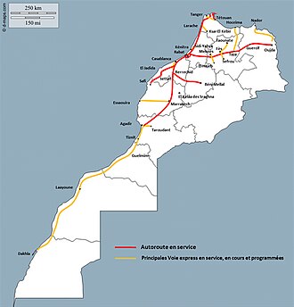
ทางหลวงและทางด่วนของโมร็อกโกเป็นเครือข่ายทางหลวงหลายเลนความเร็วสูงที่มีการควบคุมการเข้าออก
ณ เดือนพฤศจิกายน 2559 ทางหลวงแผ่นดินของโมร็อกโกมีความยาวรวม 1,808 กิโลเมตร (1,123 ไมล์) และทางด่วนมีความยาว 1,093 กิโลเมตร (679 ไมล์) โมร็อกโกมีแผนที่จะขยายเครือข่ายถนน ปัจจุบันมีทางหลวงแผ่นดินยาว 3,400 กิโลเมตร (2,100 ไมล์) และทางด่วนยาว 2,100 กิโลเมตร (1,300 ไมล์) ที่อยู่ระหว่างการก่อสร้างในหลายพื้นที่ของประเทศ
ในปี 2035 ความยาวรวมของทางหลวงจะอยู่ที่ 5,185 กิโลเมตร (3,222 ไมล์) และทางด่วน 3,700 กิโลเมตร (2,300 ไมล์) ตามที่รัฐมนตรีของโมร็อกโกกล่าว แผนนี้ยังรวมถึงโครงการเฉพาะสำหรับถนนในชนบท โดยจะก่อสร้างถนนยาว 30,000 กิโลเมตร (19,000 ไมล์) ด้วยงบประมาณลงทุน 30 พันล้านดีร์แฮม
 ทางด่วนสายแรกของโมร็อกโก - A1 คาซาบลังกา–ราบัต
 ด่านเก็บค่าผ่านทางที่บูซนิกา


โมซัมบิก
ทางหลวงของโมซัมบิก แบ่งออกเป็นสองประเภท คือ ทางหลวงแห่งชาติหรือทางหลวงสายหลัก ( estrada nacionalหรือestrada primária ) และทางหลวงระดับภูมิภาคหรือทางหลวงสายรอง ( estradas secundáriasและestradas terciárias ) ทางหลวงแห่งชาติจะมีคำนำหน้า "N" หรือ "EN" ตามด้วยตัวเลขหนึ่งหรือสองหลัก โดยทั่วไปตัวเลขจะเพิ่มขึ้นจากทางใต้ของประเทศไปทางเหนือ ส่วนทางหลวงระดับภูมิภาคจะมีคำนำหน้า "R" ตามด้วยตัวเลขสามหลัก โมซัมบิกมีถนนลาดยางมากกว่า 32,000 กิโลเมตร (20,000 ไมล์)
ไนจีเรีย
ไนจีเรียมีเครือข่ายทางหลวงที่ใหญ่ที่สุดในแอฟริกาตะวันตกแม้ว่าทางหลวงส่วนใหญ่จะได้รับการบำรุงรักษาไม่ดีนัก แต่หน่วยงานบำรุงรักษาทางหลวงของรัฐบาลกลางก็ได้ปรับปรุงทางหลวงเหล่านั้นอย่างมาก เนื่องจากที่ตั้งทางยุทธศาสตร์ของไนจีเรีย ทำให้ มีเส้นทาง ทางหลวงข้ามทวีปแอฟริกา 4 เส้นทาง ตั้งอยู่ในประเทศ ได้แก่ทางหลวงข้ามทะเลทรายซา ฮารา ไปยังแอลจีเรียทางหลวงข้ามทะเลทรายซาเฮ ล ไปยังดักการ์ประเทศเซเนกัลทางหลวงข้ามชายฝั่งแอฟริกาตะวันตกและทางหลวงลากอส-มอมบาซา
แอฟริกาใต้


In South Africa, the term freeway differs from most other parts of the world. A freeway is a road where certain restrictions apply.[73]
The following are forbidden from using a freeway:
- a vehicle drawn by an animal;
- a pedal cycle (such as a bicycle);
- a motorcycle having an engine with a cylinder capacity not exceeding 50 cm3 or that is propelled by electrical power;
- a motor tricycle or motor quadricycle;
- pedestrians
Drivers may not use hand signals on a freeway (except in emergencies) and the minimum speed on a freeway is 60 km/h (37 mph). Drivers in the rightmost lane of multi-carriageway freeways must move to the left if a faster vehicle approaches from behind to overtake.
Despite popular opinion that "freeway" means a road with at least two carriageways, single carriageway freeways exist, as is evidenced by the statement that "[South Africa's] roads include 1,400 km (870 mi) of dual carriageway freeway, 440 km (270 mi) of single carriageway freeway and 5,300 km (3,300 mi) of single carriage main road with unlimited access."[74]
Americas

Argentina

Argentina has a national route system. It is connected to the Pan-American Highway. Argentina has a total of over 82,000 km (51,000 mi) of paved roads.[75]
Brazil

Few highways in Brazil prohibit cyclists or pedestrians and are built according to the motorway standards defined by the Vienna Convention on Road Traffic,[76] ratified by Brazil in 1980.[77] There is no distinct designation for controlled-access highways in the Brazilian federal and state highway systems. The term autoestrada (Portuguese for "motorway" or "freeway") is not commonly used in Brazil; the terms estrada ("road") and especially rodovia ("highway") are instead preferred, though neither refers specifically to motorways. Nevertheless, the most technically advanced motorways in Brazil are defined Class 0 expressways by the National Department of Transport Infrastructure (DNIT). These expressways are built to safely allow for vehicular speeds of up to 130 km/h (81 mph). In mountainous terrain, the maximum allowable gradient is 5%, and the minimum allowable radius of curvature is 665 m (2,182 ft) (with 12% super-elevation).
São Paulo state has the most motorways in the country. It is also the state with more highways conceded to the private sector.
Brazil's first expressway, the Rodovia Anhanguera in São Paulo state, was completed in 1953 as an upgrade of the earlier undivided highway. That same year, construction of the second highway, Rodovia Anchieta, between São Paulo and the Atlantic coast, began. Expressway construction, most of them upgrades of older undivided highways, quickened in the following decades. The current Class 0 expressways include: Rodovia dos Bandeirantes, Rodovia dos Imigrantes, Rodovia Castelo Branco, Rodovia Ayrton Senna/Carvalho Pinto, Rodovia Osvaldo Aranha (also known as "Free-way") and São Paulo's Metropolitan Beltway Rodoanel Mário Covas – all modern, post-1970s highways meeting modern European standards. Other stretches of highway such as the under-construction south BR-101 and Rodovia Régis Bittencourt are of older design standards.


 BR-116 in Ceará


British overseas territories

A number of the United Kingdom's overseas territories have controlled-access highways, including the Turks and Caicos Islands and Cayman Islands.
Canada

Canada has no current national system for controlled-access highways. All controlled-access freeways, including sections that form part of the Trans-Canada Highway, are under provincial jurisdiction, and have no numeric continuation across provincial boundaries. The largest networks in the country are in Ontario (400-series highways) and Quebec (Autoroutes). Speed limits are not federally set, since provincial governments set speed limits for their respective regions. These roads are influenced by, and have influenced, US standards, but have design innovations and differences. The total length of dual-carriageways with controlled access in Canada is 6,350 km (3,950 mi), of which 564 km (350 mi) are in British Columbia, 642 km (399 mi) in Alberta, 59 km (37 mi) in Saskatchewan, 2,135 km (1,327 mi) in Ontario, 1,941 km (1,206 mi) in Quebec, and 1,000 km (620 mi) in the Maritimes.
El Salvador
The RN-21 (East–West, Boulevard Monseñor Romero), is the very first freeway to be built in El Salvador and in Central America. The freeway passes the northern area of the city of Santa Tecla, La Libertad. It has a small portion serving Antiguo Cuscatlán, La Libertad, and merges with the RN-5 (East–West, Boulevard de Los Proceres/Autopista del Aeropuerto) in San Salvador. The total length of the RN-21 is 9.35 km (5.81 mi) and is currently working as a traffic reliever in the metropolitan area. Although the RN-21 was to be named in honour of the first mayor of San Salvador, Diego de Holguín, due to political reasons it was renamed Boulevard Monseñor Romero, in honour of Óscar Romero. The first phase of the highway was completed in 2009, and the second phase was completed and opened in November 2012.
Mexico


In Mexico, federal highways (Spanish: Carretera Federal) are a series of highways that connect with roads from foreign countries or that link two or more states of the Federation.
 Mezcala Bridge on Highway 95 in Mexico
 Tehuantepec, Baja California
 Mexican Federal Highway 1 Junction in San Ignacio, Baja California Sur
 Eastbound Fed. 2 just outside Altar, Sonora, after a summer rain


United States


In the United States, a freeway is defined by the US government's Manual on Uniform Traffic Control Devices as a divided highway with full control of access.[78] This means two things: first, adjoining property owners do not have a legal right of access,[79] meaning all existing driveways must be removed and access to adjacent private lands must be blocked with fences or walls; instead, frontage roads provide access to properties adjacent to a freeway in many places.
Second, traffic on a freeway is "free-flowing". All cross-traffic (and left-turning traffic) is relegated to overpasses or underpasses, so that there are no traffic conflicts on the main line of the highway, which must be regulated by traffic lights, stop signs, or other traffic control devices. Achieving such free flow requires the construction of many overpasses, underpasses, and ramp systems. The advantage of grade-separated interchanges is that freeway drivers can almost always maintain their speed at junctions since they do not need to yield to vehicles crossing perpendicular to mainline traffic.
In contrast, an expressway is defined as a divided highway with partial control of access.[80] Expressways may have driveways and at-grade intersections, though these are usually less numerous than on ordinary arterial roads.
This distinction was first developed in 1949 by the Special Committee on Nomenclature of what is now the American Association of State Highway and Transportation Officials.[81] Prior to that distinction the first freeways were complete in 1940, the Pennsylvania Turnpike and the Arroyo Seco Parkway (Pasadena Freeway).[82]
In turn, the definitions were incorporated into AASHTO's official standards book, the Manual on Uniform Traffic Control Devices, which would become the national standards book of USDOT under a 1966 federal statute. The same distinction has also been codified into the statutory law of eight states: California,[83]Minnesota,[84]Mississippi,[85]Missouri,[86]Nebraska,[87]North Dakota,[88]Ohio,[89] and Wisconsin.[90]
However, each state codified the federal distinction slightly differently. California expressways do not necessarily have to be divided, though they must have at least partial access control. For both terms to apply, in Wisconsin, a divided highway must be at least four lanes wide; and in Missouri, both terms apply only to divided highways at least 16 km (10 mi) long that are not part of the Interstate Highway System. In North Dakota and Mississippi, expressways may have "full or partial" access control and "generally" have grade separations at intersections; a freeway is then defined as an expressway with full access control. Ohio's statute is similar, but instead of the vague word "generally", it imposes a requirement that 50% of an expressway's intersections must be grade-separated for the term to apply.[91] Only Minnesota enacted the exact MUTCD definitions, in May 2008.
The term "expressway" is also used in some areas of the country for what the federal government calls "freeways".[92] Where the terms are distinguished, freeways can be characterized as expressways upgraded to full access control, while not all expressways are freeways.
Examples in the United States of roads that are technically expressways (under the federal definition), but contain the word "freeway" in their names: State Fair Freeway in Kansas, Chino Valley Freeway in California, Rockaway Freeway in New York, and Shenango Valley Freeway (a portion of US 62) in Pennsylvania.
Unlike in some jurisdictions, not all freeways in the US are part of a single national freeway network (although together with non-freeways, they form the National Highway System). For example, many state highways such as California State Route 99 have significant freeway sections. Many sections of the older United States Numbered Highway System have been upgraded to freeways but have kept their existing US Highway numbers.
In Puerto Rico, controlled access highways are named autopista.[93] Autopistas are tolled roads in the island, but toll cabins do exist on other types of roads as well. One of the best known autopistas in Puerto Rico is the Autopista Luis A. Ferré (Luis A. Ferré Expressway), which goes from San Juan, the capital to the north, to Ponce, the island's second largest city, to the south.
 I-45 and I-10/US 90 next to Downtown Houston
 Interstate 5 (I-5) in Los Angeles
 I-70 passes through Spotted Wolf Canyon at the eastern edge of the San Rafael Swell.
 I-90 crossing Lake Washington
 At the Big I in Albuquerque, New Mexico
 Aerial view of I-15 looking south from Sunset Road in the Las Vegas Valley
 Western end of I-10 at the McClure Tunnel in Santa Monica


Asia


Afghanistan

Many highways of Afghanistan were built in the 1960s with American and Soviet assistance. The Soviets built a road and tunnel through the Salang pass in 1964, connecting northern and eastern Afghanistan. A highway connecting the principal cities of Herat, Kandahar, Ghazni, and Kabul with links to highways in neighbouring Pakistan formed the primary highway. The historical Highway 1 currently connects the major cities. Afghanistan has over 42,000 km (26,000 mi) of roads, with 12,000 km (7,500 mi) being paved. The highway infrastructure is currently going through reconstruction and can often be risky due to the instability of the country.
Armenia
Armenia has about 8,140 km (5,060 mi) of paved roads, of which 96% are asphalted. Armenia is connected to Europe through the International E-road network and Asia through the Asian Highway Network. Armenia is a member of the International Road Transport Union and the TIR Convention.
Azerbaijan
Azerbaijan has about 29,000 km (18,000 mi) of paved roads; the first paved roads were built during the Russian Empire. The road network, from rural roads to motorways, is today undergoing a rapid modernization with rehabilitations and extensions. For every 1,000 km2 (390 sq mi) of national territory, there are 334 km (208 mi) of roads. Azerbaijan is connected to Europe through the International E-road network and Asia through the Asian Highway Network.
China


The expressway network of China, with the national-level expressway system officially known as the National Trunk Highway System (Chinese: 中国国家干线公路系统; pinyin: Zhōngguó Guójiā Gànxiàn Gōnglù Xìtǒng; abbreviated as NTHS), is an integrated system of national and provincial-level expressways in China.[94][95]
By the end of 2019, the total length of China's expressway network reached 149,600 km (93,000 mi),[96] the world's largest expressway system by length, having surpassed the overall length of the American Interstate Highway System in 2011.[97] Planned length is 168,478 km (104,687 mi) by 2020.[97]
Expressways in China are a fairly recent addition to a complicated network of roads. According to Chinese government sources, China did not have any expressways before 1988.[98] One of the earliest expressways nationwide was the Jingshi Expressway between Beijing and Shijiazhuang in Hebei province. This expressway now forms part of the Jingzhu Expressway, currently one of the longest expressways nationwide at over 2,000 km (1,200 mi).
 The expressway crosses the Yangtze River over the Jiangyin Suspension Bridge
 G106, Jingkai Expressway section in southern Beijing
 G6 expressway at the interchange with the Fifth Ring Road in northern Beijing
 Signs using the new numbering system as seen on China National Expressway 1 in Tianjin


Georgia

The road network in Georgia consists of 1,595 km (991 mi) of main or international highways in good condition, of which by 2021 roughly 230 kilometres (140 mi) are controlled-access highway, while further expansion is ongoing. The 7,000 kilometres (4,300 mi) of domestic main roads are of mixed quality, although the conditions are improving. Some 12,400 kilometres (7,700 mi) of local roads are generally in poor condition. Georgia is connected to Europe via the International E-road network and Asia through the Asian Highway Network.
Hong Kong


In Hong Kong major motorways are numbered from 1 to 10 in addition to their names. Speed limits on expressways typically range from 70 to 110 km/h (43 to 68 mph).
 North Lantau Highway on Lantau Island
 Tolo Highway in Ma Liu Shui
 Fanling Highway in Sheung Shui
 North West Tsing Yi Interchange near Tsing Ma Bridge (Lantau Link)


India

Expressways (known as "Gatimarg/गतिमार्ग", or "Speedways" in Hindi and other Indian languages) are the highest class of roads in India's road network and currently make up around 45,890 km (28,510 mi) of the National Highway System, with additional 21,637 km (13,445 mi) under various phases of implementation. They have a minimum of six or eight-lane controlled-access highways where entrance and exit is controlled by the use of slip roads. The expressways are operated and maintained by the Union, through the National Highways Authority of India.
 Section of the Delhi Gurgaon Expressway

 A section of Noida–Greater Noida Expressway


Indonesia


In Indonesia all expressways (Indonesian: Jalan Bebas Hambatan, "obstacle-free road") are tolled, so they are better known as toll road (Jalan Tol). Indonesia has 1,710 km (1,060 mi) expressway length so far, almost 70% of its expressways are in Java island.
In 2009, the Indonesian government had planned to expand more expressway network in Java island by connecting Merak to Banyuwangi which is the total length of Trans-Java toll road including large cities expressway in Java such as Jakarta, Surabaya, Bandung and its complements is more than 1,000 km (620 mi). The Indonesian government also had planned to build the Trans-Sumatra toll road which connects Banda Aceh to Bakauheni spanning 2,700 km (1,700 mi). In 2012, the government allocated 150 trillion rupiah for the construction of the toll roads. There are three stages of construction of Trans-Sumatra toll road which is expected to be connected together in 2025.[99]
The other islands in Indonesia such as Kalimantan, Sulawesi also has begun constructed its expressways including connecting Manado to Makassar in Sulawesi and also Pontianak to Balikpapan in Kalimantan.[100] However, there are still no plans to build an expressway in Western New Guinea due to its slow population growth. Indonesia is expected to have at least 7,000 km (4,300 mi) of expressway in 2030.
Iran


The history of freeways in Iran goes back to before the Iranian Revolution. The first freeway in Iran was built at that time, between Tehran and Karaj with additional construction and the studies of many other freeways started as well. Today Iran has about 2,160 km (1,340 mi) of freeway.
Iraq

Iraq's network of highways connects it from the inside to adjacent countries such as Syria, Turkey, Kuwait, Saudi Arabia, Jordan and Iran. When Saddam Hussein visited the United States, he was impressed at the highway style and ordered the highways to be built in American form. Freeway 1 is the longest freeway in the country, connecting from Umm Qasr Port in Basra to Ar Rutba in Anbar, spreading to a new freeway connecting it to Syria and Jordan. Iraq has about 45,550 km (28,300 mi) of highways, with 38,400 km (23,900 mi) of them paved.
Israel


Controlled-access highways in Israel are designated by a blue colour. Blue highways are completely grade-separated but may include bus stops and other elements that may slow down traffic on the right lane. Highway 6 is Israel's longest freeway. It will extend to 260 km (160 mi) in length, from Shlomi in the north to the Negev Junction in the south.[101]
Japan


National expressways (高速自動車国道, Kōsoku Jidōsha Kokudō), generally known as 高速道路 (Kōsoku Dōro), make up the majority of controlled-access highways in Japan. The network boasts an uninterrupted link between Aomori Prefecture at the northern part of Honshū and Kagoshima Prefecture at the southern part of Kyūshū, linking Shikoku as well. Additional expressways serve travellers in Hokkaidō and on Okinawa Island, although those are not connected to the Honshū-Kyūshū-Shikoku grid. Expressways have a combined length of 9,429 km (5,859 mi) as of April 2018.[102][103][104]
 Many Japanese expressways go through the steep mountains.
 A group of green-coloured directional signs on a Japanese expressway
 Toll gates are placed at most of the entrances and exits of Japanese expressways.
 Aerial view of Toyota Junction, connecting Tomei Expressway and Ise-Wangan Expressway


Lebanon
Lebanon has an extensive network of highways that are in varying condition throughout the country. Many highways are part of the Arab Mashreq International Road Network. Some highways have been upgraded to four-lane motorways, including the Beirut–Tripoli highway.
Malaysia


Controlled-access highways in Malaysia are known as expressways (Malay: lebuhraya – this is also the name for highways). However, some expressways, particularly bridges and tunnels such as the Penang Bridge, do not formally use the expressway name; a small number confusingly use the term highway, which is normally the designation for limited-access roads. Route numbers of designated expressways begin with the letter E. All expressways (excluding a section of the South Klang Valley Expressway, which is a two-lane expressway) are built with dual carriageways and at least two lanes in each direction; urban expressways generally have three or more lanes in each direction.
While all expressways are grade separated at major roadways, many urban expressways in the Greater Kuala Lumpur region often have at-grade intersections, including with residential roads and shopfronts, thus do not meet the strict definition of a controlled-access highway. These expressways were previously normal arterial or collector roads that had such intersections, and were not removed when the roads were converted to expressways due to the resulting accessibility and sometimes political issues. Despite this, no expressway allows traffic to cross the median strip (apart from U-turns on a limited number of expressways) and expressways do not have at-grade traffic signals or roundabouts. Expressways have a maximum speed limit of 110 km/h (68 mph), while speed limits of 90 km/h (56 mph) or lower are typical in built-up areas.
As of 2017, expressways have only been designated in Peninsular Malaysia. There are 34 fully or partially open expressways with an approximate total length of 1,821 km (1,132 mi).[105][106] The vast majority of expressways are tolled; the North–South Expressway network, East Coast Expressway and West Coast Expressway predominantly use the ticket system of toll collection, while all other expressways use the barrier system. The construction and operation of expressways in Malaysia are usually privatized via concession agreements with the federal government, using the build–operate–transfer system.
Pakistan


The motorways of Pakistan and expressways of Pakistan are a network of multiple-lane, high-speed, limited-access or controlled-access highways in Pakistan, which are owned, maintained and operated federally by Pakistan's National Highway Authority. The total length of Pakistan's motorways and expressways is 1,670 km (1,040 mi) as of November 2016.[107] Around 3,690 km (2,290 mi) of motorways are currently under construction in different parts of the country. Most of these motorway projects will be complete between 2018 and 2020.[108]
Pakistan's motorways are part of Pakistan's National Trade Corridor project that aims to link Pakistan's three Arabian Sea ports of Karachi, Port Qasim and Gwadar to the rest of the country. These would further link with Central Asia and China, as proposed in the China Pakistan Economic Corridor.
Pakistan's first motorway, the M-2, was inaugurated in November 1997; it is a 367-kilometre-long (228 mi), six-lane motorway that links Pakistan's federal capital, Islamabad, with Punjab's provincial capital, Lahore.[109] It is ranked among the world's top five speed highways/motorways. Other completed motorways and expressways are M1 Peshawar–Islamabad Motorway, M4 PindiBhattian–Faisalabad-Multan Motorway, E75 Islamabad-Murree–Kashmir Expressway, M3 Lahore–Multan Motorway, M8 Ratadero–Gawader Motorway, E8 Islamabad Expressway, M5 Multan-Sukkur Motorway, M9 Karachi-Hyderabad, Sindh and few others.[110]
 The motorway M-2 passes through the Salt Range mountains.
 M-1 motorway westbound towards Peshawar
 M-1 Peshawar Toll Plaza
 The Makran Coastal Highway (N10) passing through Balochistan


Philippines


Full control-access highways in the Philippines are referred to as expressways, which are usually toll roads. The expressway network is concentrated in Luzon, with the North Luzon Expressway and South Luzon Expressway being the most important ones. The expressway network in Luzon do not form an integrated network, but there are ongoing construction projects to interconnect those highways as well as to decongest the existing roads in the areas they serve. Expressways are being introduced to Visayas and Mindanao through the construction of the Cebu–Cordova Link Expressway in Metro Cebu and Davao City Expressway in Davao City.
 A portion of North Luzon Expressway in Guiguinto, Bulacan


Saudi Arabia

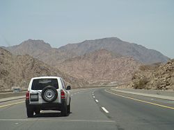
Highways in Saudi Arabia vary from eight-laned roads to small two-lane roads in rural areas. The city highways and other major highways are well maintained, especially the roads in the capital Riyadh. The roads have been constructed to resist the consistently high temperatures and do not reflect the strong sunshine. The other city highways such as the one linking coast to coast are not as great as the inner-city highways but the government is now working on rebuilding those roads. Saudi Arabia is part of the Arab-Mashreq Highway Network and connects to the rest of Asia through the Asian Highway Network.
Singapore

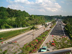

The expressways of Singapore are special roads that allow motorists to travel quickly from one urban area to another. All of them are dual carriageways with grade-separatedaccess. They usually have three to four lanes in each direction, although there are two-lane carriageways at many expressway—expressway intersections and five-lane carriageways in some places. There are ten expressways, including the new Marina Coastal Expressway. Studies about the feasibility of additional expressways are ongoing.
Construction on the first expressway, the Pan Island Expressway, started in 1966. As of 2014, there are 163 km (101 mi) of expressways in Singapore.[111]
The Singaporean expressway networks are connected with Malaysian expressway networks via Ayer Rajah Expressway (connects with the Second Link Expressway via the Malaysia–Singapore Second Link) and Bukit Timah Expressway (connects with the Eastern Dispersal Link via the Johor–Singapore Causeway).
South Korea


Since Gyeongin Expressway linking Seoul and Incheon opened in 1968, national expressway system in South Korea has been expanded into 36 routes, with total length of 4,481 km (2,784 mi) as of 2017. Most of expressways are four-lane roads, while 1,030 km (640 mi) (26%) have six to ten lanes. Speed limit is typically 100 km/h (62 mph) for routes with four or more lanes, while some sections having fewer curves have limit of 110 km/h (68 mph).
Expressways in South Korea were originally numbered in order of construction. Since 24 August 2001, they have been numbered in a scheme somewhat similar to that of the Interstate Highway System in the United States. Furthermore, the symbols of the South Korean highways are similar to the US red, white and blue.
- Arterial routes are designated by two-digit numbers, with north–south routes having odd numbers, and east–west routes having even numbers. Primary routes (i.e. major thoroughfares) have 5 or 0 as their last digit, while secondary routes end in other digits.
- Branch routes have three-digit route numbers, where the first two digits match the route number of an arterial route. This differs from the American system, whose last two digits match the primary route.
- Belt lines have three-digit route numbers where the first digit matches the respective city's postal code. This also differs from American numbering.
- Route numbers in the range 70–99 are not used in South Korea; they are reserved for designations in the event of Korean reunification.
- The Gyeongbu Expressway kept its Route 1 designation, as it is South Korea's first and most important expressway.
 Approaching Seoul from Incheon Airport
 Airport Town Square junction
 Incheon Bridge Toll Gate


Sri Lanka


Sri Lanka currently has over 350 km (220 mi) of designated expressways serving the southern part of the country. The first stage of the E01 Expressway (Southern Expressway) which opened in 2011 was Sri Lanka's first expressway spanning a distance of 95.3 km (59.2 mi). The second stage of the Southern Expressway opened in 2014 and extends to Matara. The E03 Expressway (Colombo–Katunayake Expressway) opened in 2013 and connects Sri Lanka's largest city Colombo with the Bandaranaike International Airport covering a distance of 25.8 km (16.0 mi). All E-Grade highways in Sri Lanka are access controlled, toll roads with speeds limits in the range of 80–110 km/h (50–68 mph). The network is to be expanded to 518.5 km (322.2 mi) by 2024.
Operational (fully or partially):
 E01Kottawa-Hambantota
 E02Kottawa-Kerawalapitiya
 E03Colombo-Katunayake
 E04 Enderamulla-Kurunegala-Kandy
 E06 Kahatuduwa-Pelmadulla
Planned:
- Colombo Metropolitan expressway (Colombo Fort to Peliyagoda, connecting Colombo with the E03 expressway (Sri Lanka) Colombo-Katunayaka expressway.)
Syria

Syria has a well-developed system of motorways in the western half of the country. As the eastern part is underpopulated, it only has two lanes. Highways have been important in terms of transport for the ongoing civil war. The main motorways are:
- M1 - Runs from Homs to Latakia. It also connects Tartus, Baniyas and Jableh. Its length is 174 km (108 mi).
- M2 - Runs from Damascus to Jdeidat Yabous, on the border with Lebanon. It also connects Al-Sabboura. Its length is 38 km (24 mi).
- M4 - Runs from Latakia to Saraqib. It also connects Arihah and Jisr al-Shughur. Its length is 120 km (75 mi). It continues to the Iraqi border all the way to Mosul.
- M5 - Often described as the most important highway, it runs through much of the major cities in Syria and runs to the Jordanian border.
Taiwan (Republic of China)


Taiwan has an extensive road network that includes two types of controlled-access highway: freeways and expressways. Only cars and trucks are allowed onto freeways, the first of which — Freeway 1 — was completed in 1974. Expressways allow car and truck traffic as well as motorcycles with engines of 250cc or more.
Expressways in Taiwan may be controlled-access highways similar to national freeways or limited-access roads. Most have urban roads and intra-city expressways (as opposed to Highway system) status, although some are built and maintained by cities.

 Taichung section
 Freeway entrance


Thailand


Controlled-access highways in Thailand are separated into urban expressways called expressways, which are operated by the Expressway Authority of Thailand and BEM (except Don Mueang Tollway, which is operated by Don Muang Tollway Public Company Limited) and have a span of 280.4 km (174.2 mi), while intercity expressways are called motorways, which have a span of 187 km (116 mi). The network is to be extended to 4,154.7 km (2,581.6 mi) according to the master plan.
 A motorway interchange in Makkasan, Bangkok
 Srinagarindra Interchange head to Rama IX Road


Uzbekistan

Uzbekistan has 84,400 km (52,400 mi) of roads, about 72,000 km (45,000 mi) of which were paved. Much of the highways are in need of repair, although the condition has been improving. In 2017, the governments of Kazakhstan and Uzbekistan agreed to open a section of the M39 Highway by the Kazakh border.
Vietnam


At present, the expressway system of Vietnam is 3,345 km (2,078 mi) long. The Vietnamese government plans to complete the national expressway system with a total length of 9,000 km (5,600 mi) by 2045. The expressway system in Vietnam is separate from the national highway system.[112]
Most of the expressways are located in the North, especially around Hanoi. Of the 21 expressways in Vietnam, 8 emanate from Hanoi and 14 are in the north, with a length of 1,368 km (850 mi). The first expressway in Vietnam is the Ho Chi Minh City - Trung Luong Expressway, which is inaugurated and opened for traffic on 3 February 2010.
Currently, most of the expressways in Vietnam are four-lane highways, with some routes like Ha Noi - Haiphong, and Phap Van - Cau Gie being six-lane. The only elevated expressway in Vietnam is Mai Dich - Thanh Tri Bridge (also known as the third beltway in Hanoi). The cost of building Vietnam's highways is one of the most expensive in the world, with an average cost of $12 million per kilometre. Compared with China, where there are similarities, their highway costs only $5 million per kilometre, where in the US and European countries, costs $3–4 million per kilometre.[113]
According to road traffic laws of Vietnam, an expressway is a road for motor vehicles, with a divider separating opposing traffic directions, no at-grade crossings with intersecting roads, fully equipped facilities to ensure continuous traffic flow, safety and short journey times, and access allowed only at interchanges.
 Ha Noi - Bac Giang Expressway in Bac Ninh
 Long Thanh bridge of Ho Chi Minh City - Long Thanh - Dau Giay Expressway
 Cho Dem - Ben Luc elevated part of Ho Chi Minh City - Trung Luong Expressway
 Lien Khuong - Prenn Pass Expressway
 Van Tien bridge of Hai Phong - Mong Cai Expressway


Europe
Regarding road function, motorways serve exclusively the function of flow. They allow for efficient throughput of, usually long distance, motorized traffic, with unhindered flow of traffic, no traffic signals, at-grade intersections or property access and elimination of conflicts with other directions of traffic, thus, dramatically improving both safety and capacity.[24]
Although roads are under the responsibility of each individual state, including within the European Union, there are some legal conventions (international treaties) and some European directives which give a legal framework for roads of a European importance with the goal to introduce some kind of homogenization between various members. They basically consider, at European level, three types of roads: motorways, express roads, and ordinary roads.[114]
Some European treaties also define aspects such as the range of speed limit, or for some geometric aspects of roads, in particularly for the International E-road network.
According to Eurostat:
A motorway is a road specially designed and built for motor vehicle traffic, which does not directly provide access to the properties bordering on it. Other characteristics of motorways include:
- two separated carriageways for the opposing directions of traffic, except at special points or, temporarily, due to carriageway repairs etc.;
- carriageways that are not crossed at the level of the carriageway by any other road, railway or tramway track, or footpath; and
- the use of special signposting to indicate the road as a motorway and to exclude specific categories of road vehicles and/ or road users.
In determining the extent of a motorway its entry and exit lanes are included irrespective of the location of the motorway signposts. Urban motorways are also included in this term.
Most of the European countries use the above motorway definition but different national definitions of motorways can be found in some countries.[24]
It is usually[24] considered that:
- Motorways serve exclusively motorized traffic.
- Motorways have separate carriageways for the two directions of traffic.
- Motorways are not crossed at the same level by other roads, footpaths, railways
- Traffic entrance and exit is performed at interchanges only.
- Motorways have no access for traffic between interchanges and do not provide access to adjacent land.
- Motorways are especially sign-posted
Motorways status is signalled at the entry and exit of the motorway by a symbol conforming to international agreements, but specific to each country.[115]
 Sweden
 Spain
Spain Germany
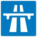 United Kingdom, Ireland
 Switzerland
 France
 Italy and Albania
 Romania
 Slovakia
 Portugal
 North Macedonia


The peripheral northern and eastern regions of the EU have a lower density motorway network. Within the European Union, there are 26 regions (NUTS level 2) with no motorway network in 2013. Those regions are islands or remote regions, for instance four overseas French regions and Corsica. The Baltic member state of Latvia, as well as four regions from Poland, and two regions from each of Bulgaria and Romania also reported no motorway network; several of these regions bordered onto adjacent non-member countries to the east of the EU.[116]
European motorways provide reduced accident risks: 50% to 90% lower compared to standard roads, when new motorways only reduce injuries by 7%.[24]
Some of the things which are considered as providing safety in the European motorways are central medians, grade separated interchanges, and access restrictions.[24]
Nonetheless, some specific conditions provide a height risk of a more severe accidents, such as:
- improper use of emergency lane,
- cross-median head-on accidents,
- wrong direction accidents.[24]
Albania


Highways in Albania form part of the recent Albanian road system. Following the collapse of communism in 1991, the first highways in Albania started being constructed, The first was SH2, connecting Tirane with Durrës via Vora. Since the 2000s, main roadways have drastically improved, though lacking standards in design and road safety.[117][118] This involved the construction of new roadways and the putting of contemporary signs. However, some state roads continue to deteriorate from lack of maintenance while others remain unfinished.
 A1 Nation's Highway in Northern Albania connecting Albania with Kosovo
 Krraba Tunnel on the A3 Tirana, Elbasan, Albania
 A2 Fier - Vlore known as the Independence Highway


Austria


The Austrian autobahns (German: Autobahnen) are controlled-access highways in Austria. They are officially called German: Bundesstraßen A (Bundesautobahnen) under the authority of the federal government according to the Austrian Federal Road Act (Bundesstraßengesetz),[119] not to be confused with the former Bundesstraßen highways maintained by the Austrian states since 2002.
Austria currently has 18 Autobahnen, since 1982 built and maintained by the self-financed ASFiNAG stock company in Vienna, which is wholly owned by the Austrian republic and earns revenue from road-user charges and tolls. Each route bears a number as well as an official name with local reference, which however is not displayed on road signs. Unusually for European countries, interchanges (between motorways called Knoten, "knots") are numbered by distance in kilometres starting from where the route begins; this arrangement is also used in the Czech Republic, Slovakia, Hungary, Spain, and most provinces of Canada (and in most American states, albeit in miles). The current Austrian Autobahn network has a total length of 1,720 km (1,070 mi).
 Brenner Autobahn near Innsbruck
 A22 Donauuferautobahn, near the exit Floridsdorfer Brücke


Belgium


In 1937, the first motorway between Brussels and Ostend was completed, following the example of neighbouring countries such as Germany. It mainly served local industries and tourism as a connection between the capital city and a coastal region. However, the Second World War and the reparation of the complete road network after the war caused a serious delay in the creation of other motorways. In 1949, the first plans were made to build a complete motorway network of 930 km (580 mi) that would be integrated with the neighbouring networks. Although the plans were ready, the construction of the motorway network was much slower than in neighbouring countries because the project was deemed not to be urgent.
Because of economic growth in the 1960s, more citizens could afford cars, and the call for good-quality roads was higher than ever before. In each year between 1965 and 1973, over 100 km (62 mi) of motorway were built. At the end of the 1970s, the construction of motorways slowed down again due to costs, combined with an economic crisis, more expensive fuel and changing public opinion. In the following years, the only investments done were to complete already started motorway constructions. But most important cities were already connected. In 1981, the responsibilities for construction and maintenance of the motorways shifted from the federal to the regional governments. This sometimes caused tensions between the governments. For example, the part of the ring road around Brussels that crosses Wallonian territory has never been finished, since only Flanders suffers from the unfinished ring.[120]
Belgium today has the longest total motorway length per area unit of any country in the world. Most motorway systems in Belgium have at least three lanes in each direction. Nearly all motorways have overhead lighting including those in rural areas. The dense population of Belgium and the still unfinished state of some motorways, such as the ring roads around Brussels and Antwerp cause major traffic congestion on motorways. On an average Monday morning in 2012, there was a total of 356 km (221 mi)[121] of traffic jams and the longest traffic jam of the year was 1,258 km (782 mi),[122] purely on the motorways.
Bosnia and Herzegovina


Bosnia and Herzegovina has more than 208 km (129 mi) of highway, which connects Kakanj-Sarajevo. There is a plan to build highway on Corridor Vc, which will go from river Sava, across Doboj, Sarajevo and Mostar to Adriatic Sea. Next sections are Kakanj-Drivuša 16 km (9.9 mi), Zenica Sjever-Drivuša 11 km (6.8 mi), Svilaj-Odžak 11 km (6.8 mi), Vlakovo-Tarčin 20 km (12 mi), Počitelj-Bijača 21 km (13 mi). The speed limit is 130 km/h (81 mph) or 100 km/h (62 mph) in tunnels.[123]

 Mahovljanska interchange
 A1 motorway


Bulgaria


Legislation in Bulgaria defines two types of highways: motorways (Aвтомагистрала, Avtomagistrala) and expressways (Скоростен път, Skorosten pat). The main differences are that motorways have emergency lanes and the maximum allowed speed limit is 140 km/h (87 mph), while expressways do not have emergency lanes and the speed limit is 120 km/h (75 mph). As of June 2018, 777 km (483 mi) of motorways are in service, with another 62 km (39 mi) under various stages of construction. More than 590 km (370 mi) are planned. Also, several expressways are planned.
 Trakia motorway near Nova Zagora
 Europe motorway


Croatia


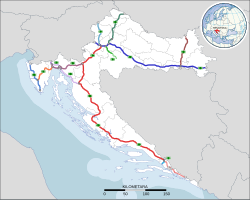
The primary high-speed motorways in Croatia are called autoceste (singular: autocesta; Croatian pronunciation:[ˈaʊtotsesta]), and they are defined as roads with at least two lanes in each direction (including hard shoulder) and a speed limit of not less than 80 km/h (50 mph). The typical speed limit is 130 km/h (81 mph). As of 2025, there are 1,360.5 km (845.4 mi) of motorways in Croatia. There is also a category known as brza cesta, meaning "expressway". These roads have a speed limit up to 110 km/h (68 mph) and are not legally required to be grade-separated, but nearly all are.
Cyprus


Motorways (Greek: αυτοκινητόδρομος, Turkish: Otoyol) connect all cities in Cyprus, although in the territory under de facto Turkish control these do not meet international standards for the definition of motorways. In the areas administered by the Republic of Cyprus, motorway numbers are prefaced with the letter A, and run from A1 to A6, to distinguish them from all other roads, designated B roads. Of the A roads, all are designated motorways, except for the A4, linking Larnaca with Larnaca Airport.
Motorways are also distinguishable by the use of green-backed road signs, with standard international graphics, and text in yellow in Greek and white in English, distinguishable from B road signage, which has signs with blue backgrounds.
Motorway junctions are theoretically designated with junction numbers, but signage is not consistent is indicating the exit numbers.
Czech Republic


The Czech Republic has currently (2023) 1,363 km (847 mi)[124] of motorways (dálnice) whose speed limit is 130 km/h (81 mph) (or 80 km/h (50 mph) within a town). The total length should be 2,000 km (1,200 mi) around 2030. The number of a motorway (in red) copies the number of the national route (in blue) which has been replaced by the motorway. There are also roads for motorcars (silnice pro motorová vozidla). Those common roads are not subject to a fee (in form of vignette) for vehicles with total weight up to 3.5 t (3.4 long tons; 3.9 short tons) and their speed limit is 110 km/h (68 mph), partially up to 130 km/h (81 mph).
Denmark


Denmark has a well covered motorway system today, which has been difficult to build due to the county's geography with many islands. The longest bridges are the Great Belt and the Øresund bridges to Skåne (Scania) in southern Sweden. Both are motorways with dual electrical train tracks added.
Finland


Finland has 863 km (536 mi) of motorway, which is only a small proportion of the whole highway network. More than half of the length of the motorway network consists of six radial motorways originating in Helsinki, to Kirkkonummi (Länsiväylä), Turku (Vt1/E18), Tampere (Vt3/E12), Tuusula (Kt45), Heinola (Vt4/E75) and Vaalimaa (Vt7/E18). These roads have a total length of 653 km (406 mi). The other motorways are rather short sections close to the biggest cities, often designed to be bypasses. The motorway section on national roads 4 and 29, between Simo and Tornio, is said to be the northernmost motorway in the world.
Finnish motorways do not have a separate road numbering scheme. Instead, they carry national highway numbers. In addition to signposted motorways, there are also some limited-access two-lane expressways, and other grade-separated four-lane expressways (perhaps the most significant example being Ring III near Helsinki).
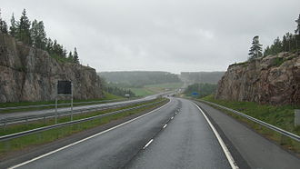 Valtatie 1 near Halikko


France


The autoroute system in France consists largely of toll roads, except around large cities and in parts of the north. It is a network of 11,882 km (7,383 mi) worth of motorways. Autoroute destinations are shown in blue, while destinations reached through a combination of autoroutes are shown with an added autoroute logo. Toll autoroutes are signalled with the word péage (toll).
 Cross between A430 motorway and A43 motorway
 Toll barrier in Hordain (south of Hordain), on autoroute A2


Germany

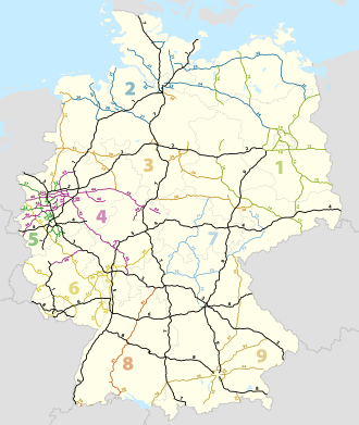

Germany's network of controlled-access expressways includes all federal Autobahnen and some parts of Bundesstraßen and usually no Landesstraßen (state highways), Kreisstraßen (district highways) nor Gemeindestraßen (municipal highways). The federal Autobahn network has a total length of 13,183 km (8,192 mi) in 2020, making it one of the densest networks in the world. The German autobahns have no general speed limit for some classes of vehicles (though nearly 30% of the total autobahn network is subject to local and/or conditional limits[125]), but the advisory speed limit (Richtgeschwindigkeit) is 130 km/h (81 mph). The lower class expressways usually have speed limits of 120 km/h (75 mph) or lower.
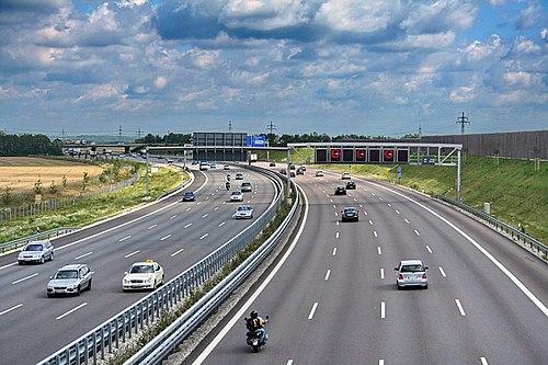 German Motorway (Autobahn) - one of the world's earliest motorways
 An autobahn with 4 lanes in each direction of travel for 21 km (13 mi). The section between Zeppelinheim and Darmstadt is the oldest Autobahn.
 The A 3 in 1991
 Dynamic traffic signs on an Autobahn


Greece


Greece's motorway network has been extensively modernised throughout the 1980s, 1990s and especially the 2000s, while part of it is still under construction. Most of it was completed by mid 2017 numbering around 2,500 km (1,600 mi) of motorways, making it the biggest highway network in Southeastern Europe and the Balkans and one of the most advanced in Europe.[126]
There are a total of 10 main routes throughout the Greek mainland and Crete, from which some feature numerous branches and auxiliary routes. Most important motorways are the A1 Motorway connecting Greece's two largest cities (Athens and Thessaloniki), the A2 motorway (Egnatia Odos), also known as the "horizontal road axis" of Greece, connecting almost all of Northern Greece from west to east and the A8 motorway (Olympia Odos) connecting Athens and Patras. Another important motorway is the A6 motorway (Attiki Odos), the main beltway of the Athens Metropolitan area.


Hungary


In Hungary, a controlled-access highway is called an autópálya (plural autópályák).
 Eastern section of M0
 M7 motorway in Köröshegyi völgyhíd
 M1 - M7 common phase, near Budapest


Ireland


In Ireland the Local Government (Roads and Motorways) Act 1974 made motorways possible, although the first section, the M7 Naas Bypass, did not open until 1983. The first section of the M50 opened in 1990, a part of which was Ireland's first toll motorway, the West-Link. However it would be the 1990s before substantial sections of motorway were opened in Ireland, with the first completed motorway—the 83-kilometre (52 mi) M1 motorway—being finished in 2005.
Under the Transport 21 infrastructural plan,[127] motorways or high quality dual carriageways were built between Dublin and the major cities of Cork, Galway, Limerick and Waterford by the end of 2010. Other shorter sections of motorway either have been or will be built on some other main routes. In 2007 legislation (the Roads Bill 2007) was created to allow existing roads be designated motorways by order because previously legislation allowed only for newly built roads to be designated motorways.
As a result, most HQDCs nationwide (other than some sections near Dublin on the N4 and N7, which did not fully meet motorway standards) were reclassified as motorways. The first stage in this process occurred when all the HQDC schemes open or under construction on the N7 and N8, and between Kinnegad and Athlone on the N6 and Kilcullen and south of Carlow on the N9, were reclassified motorway on 24 September 2008. Further sections of dual carriageway were reclassified in 2009.
As of December 2011, the Republic of Ireland has around 1,017 km (632 mi) of motorways.


Italy


Roads in Italy are an important mode of transport in Italy. The world's first motorway was the Autostrada dei laghi, inaugurated on 21 September 1924 in Italy. It linked Milan to Varese; it was then extended to Como, near the border with Switzerland, inaugurated on 28 June 1925. Piero Puricelli, the engineer who designed this new type of road, decided to cover the expenses by introducing a toll.[128][129]
Other motorways (or autostrade) built before World War II in Italy were Naples-Pompeii, Florence-Pisa, Padua-Venice, Milan-Turin, Milan-Bergamo-Brescia and Rome-Ostia. The total length of the Italian motorway system is about 7,016 kilometres (4,360 mi), as of 30 July 2022.[130] To these data are added 13 motorway spur routes, which extend for 355 kilometres (221 mi).[131] The density is 22.4 kilometres (13.9 mi) of motorway for every 1,000 square kilometres (390 sq mi) of Italian territory.[132]
Italian motorways (or autostrade) are mostly managed by concessionaire companies. From 1 October 2012 the granting body is the Ministry of Infrastructure and Transport and no longer Anas[133] and the majority (5,773.4 kilometres (3,587.4 mi) in 2009[134]) are subject to toll payments. On Italian motorways, the toll applies to almost all motorways not managed by Anas. The collection of motorway tolls, from a tariff point of view, is managed mainly in two ways: either through the "closed motorway system" (km travelled) or through the "open motorway system" (flat-rate toll).[135]
Italy's motorways (or autostrade) have a standard speed limit of 130 km/h (80 mph) for cars. Limits for other vehicles (or when visibility is poor due to weather) are lower. Legal provisions allow operators to set the limit to 150 km/h (95 mph) on their concessions on a voluntary basis if there are three lanes in each direction and a working SICVE, or Safety Tutor, which is a speed-camera system that measures the average speed over a given distance.
Type B highway (Italian: strada extraurbana principale), commonly but unofficially known as superstrada (Italian equivalent for expressway), is a divided highway with at least two lanes in each direction, paved shoulder on the right, no cross-traffic and no at-grade intersections. Access restrictions on such highways are exactly the same as motorways (or autostrade). The signage at the beginning and the end of the strade extraurbane principali is the same, except the background colour is blue instead of green. The general speed limit on strade extraurbane principali is 110 km/h (70 mph), unless otherwise indicated. Strade extraurbane principali are not tolled.


 Autostrada A22 runs through Po Valley and Alps linking Modena to Brenner Pass, a mountain pass which forms the border betweenItaly and Austria


Kosovo
Kosovo's motorways (pronounced Austostrada/Autostradë in Albanian, and Autoput in Serbian) include for example, R7 (Ibrahim Rugova Highway) connecting to Albania's A1 (Rruga e Kombit), and it also connects to E80 in the E-Road network.
Latvia

There is currently one category of controlled-access highways in Latvia, which are expressways (Latvian: ātrgaitas ceļš) with maximum speed 120 km/h (75 mph). The first expressway in Latvia opened in October 2023, the Ķekava Bypass, which is a part of the A7.[136] Current length of the expressway network is 11 km (6.8 mi).
Lithuania


There are two categories of controlled-access highways in Lithuania: expressways (Lithuanian: greitkeliai) with maximum speed 120 km/h (75 mph) and motorways (Lithuanian: automagistralės) with maximum speed 130 km/h (81 mph). The first section Vilnius–Kaunas of A1 highway was completed in 1970. Kaunas–Klaipėda section of A1 was completed in 1987.[137]Vilnius-Panevėžys (A2 highway) was completed in stages during the 1980s and finished in the 1990s. Complete length of the motorway network is 310 km (190 mi). Expressway network length - 80 km (50 mi). Motorway section between Kaunas and the Polish border is planned to be completed in the 2020s.
 A1 motorway near Kaunas
 A2 motorway near Taujėnai
 Motorway junction with U-turns. A2 motorway near Raguva.


Montenegro


Montenegro has had a motorway since 13 July 2022, when the first section of the Bar-Boljare motorway was inaugurated. On Montenegrin motorways, the speed-limit is 100 kilometres per hour (62 mph). In May 2015 work started on the first section in Montenegro, Smokovac - Uvač - Mateševo, with a length of 41 kilometres
 Princess Xenia motorway A-1 of July 2022

Netherlands


Roads in the Netherlands include at least 2,758 km (1,714 mi) of motorways and expressways,[138] and with a motorway density of 64 kilometres per 1,000 km2 (103 mi/1,000 mi2), the country has one of the densest motorway networks in the world.[139] About 2,500 km (1,600 mi) are fully constructed to motorway standards,[140] These are called Autosnelweg or simply snelweg, and numbered and signposted with an A and up to three digits, like A12.
They are consistently built with at least two carriageways, guard rails and interchanges with grade separation. Since September 2012, the nationwide maximum speed has been raised to 130 km/h (81 mph), but on many stretches speed is still limited to 120 or 100 km/h (75 or 62 mph). Dutch motorways may only be used by motor vehicles both capable and legally allowed to go at least 60 km/h (37 mph).
In March 2020, the general speed limit on Dutch motorways was lowered to 100 km/h (62 mph) during the day (6 am until 7 pm). At night, the maximum speed is different per stretch, but 130 km/h (81 mph) remained the upper limit.
Dutch roads are used with a very high intensity in relation to the network length[139] and traffic congestion is common, due to the country's high population density. Therefore, since 1979 large portions of the motorway network have been equipped with variable message signs and dynamic electronic displays, both of which are aspects of intelligent transportation systems. These signs can show a lower speed limit, as low as 50 km/h (31 mph), to optimize the flow of heavy traffic, and a variety of other communications. Additionally there are peak, rushhour or plus lanes, which allow motorists to use the hard shoulder as an extra traffic lane in case of congestion. These extra lanes are observed by CCTV cameras from a traffic control center.
Less common, but increasingly, separate roadways are created for local/regional traffic and long-distance traffic. This way the number of weaving motions across lanes is reduced, and the traffic capacity per lane of the road is optimized. A special feature of Dutch motorways is the use of Porous Asphalt Concrete, which allows water to drain efficiently, and even in heavy rain no water will splash up, in contrast to concrete or other road surfaces. The Netherlands is the only country that uses PAC this extensively, and the goal is to cover 100% of the motorways with PAC, in spite of the high costs of construction and maintenance.
 Local and express lanes connected using a basketweave
 Dynamic Route Information Panel (DRIP) on Dutch A13 freeway during evening rush hour


North Macedonia


The total motorway network length in North Macedonia is 317 km (197 mi) as of Spring 2019. Another 70 km (43 mi) are under construction, 57 km (35 mi) (Ohrid to Kicevo) and 13 km (8.1 mi) (Skopje to Kosovo border). The stretch from Gostivar to Kicevo is planned to start with construction in 2021. The three motorway routes are A1, which is part of the European corridor E-75, A2 (part of E-65) and the recently built A4 corridor that connects Skopje to Stip. A1 connects the northern border (Serbia) with the southern one (Greece), while A2 traverses the country from the East (Bulgaria border) to West (Albania border), but only the stretch from Kumanovo to Gostivar is a divided motorway, while the rest of the length is either an undivided two-way road or in the process of turning into a motorway.[141]
Norway

Norway has (2022) 770 km (480 mi) of motorways, in addition to 498 km (309 mi) of limited-access roads (in Norwegian motortrafikkvei) where pedestrians, bicycles, etc. are forbidden, though with a bit lower standard than true motorway. Most of the network serves the big cities, chiefly Oslo, Stavanger and Bergen. Northernmost motorway is, as of 2022, on E6 just south of Trondheim: see also the E6, E18 and the E39. Most motorways use four-ramp Dumbbell interchanges, but also Roundabout interchanges can be found. The first motorway was built in 1964, just outside Oslo. The motorways' road pattern layout is similar to those in the United States and Canada, featuring a yellow stripe towards the median, and white stripes between the lanes and on the edge. The speed limits are 90–110 km/h (56–68 mph).
Poland


The highways in Poland are divided into motorways and expressways, both types featuring grade-separated interchanges with all other roads, emergency lanes, feeder lanes, wildlife protection measures and dedicated roadside rest areas. Motorways can be only dual carriageways, while expressways can be dual or, rarely, single carriageways. The start of an expressway in Poland is marked with a sign of white car on blue background, while number sign for an expressway is of red background and white letters, with the letter S preceding a number. Speed limits in Poland are 140 km/h (87 mph) on motorways and 120 km/h (75 mph) on dual-carriageway expressways.
The Regulation of the Council of Ministers defines the network of motorways and expressways in Poland totalling about 7,980 km (4,960 mi) (including about 2,100 km (1,300 mi) of motorways).[142]
As of July 2022, there are 4,688 km (2,913 mi) of motorways and expressways in operation (58% of the intended network), while contracts for construction of further 1,170 km (727 mi) of motorways and expressways (15% of the intended network) are ongoing.[143]
 A4 near Jaworzno, opened in 1983

 Wrocław Stadion junction
 Expressway S5 near Bydgoszcz


Portugal


Portugal was the third country in Europe—after Italy and Germany—to build a motorway (Portuguese: autoestrada, plural: autoestradas), opening, in 1944, the Lisbon-Estádio Nacional section of the present A5 (Autoestrada da Costa do Estoril).[144]
Additional motorway sections were built in the 1960s, 1970s and early 1980s. However, the large-scale building of motorways started only in the late 1980s. Currently, Portugal has a very well-developed network of motorways, with about a 3,000-kilometre (1,900 mi) extension, that connects all the highly populated coastal regions of the country and the main cities of the less populous interior. This means that 87% of the Portuguese population lives at less than 15 minutes' driving time from a motorway access.[145]
Unlike the neighbouring Spanish network, most of Portuguese motorways are tolled, although there are also some non-tolled highways, mostly in urban areas, like those of Greater Lisbon and Greater Oporto. In the late 1990s and early 2000s, the Government of Portugal created seven shadow toll concessions, the SCUT toll (Sem custos para o utilizador, no costs for the user). In those concessions it were included more than 900 km (560 mi) of motorways and highways, some of them already built, others which were built in the following years. However, due to economical and political reasons, the shadow toll concept was abolished between 2010 and 2011, with electronic toll equipment being installed in these motorways, to charge their users. Having only electronic tolls, former SCUT motorways can now only be used by vehicles equipped with electronic payment devices or vehicles registered in the system.
Portuguese motorways form an independent network (Rede Nacional de Autoestradas, National Motorway Network), that overlaps with the Fundamental and Complementary subnetworks of the National Highway Network (Rede Rodoviária Nacional). Each motorway section overlapping with the Fundamental subnetwork is part of an IP (Itinerário principal, Principal route) and each motorway section overlapping with the Complementary subnetwork is part of an IC (Itinerário complementar, Complementary route). Thus, a motorway can overlap with sections of different IP or IC routes and - on the other hand - an IP or IC route can overlap with sections of different motorways. An example is A22 motorway, which overlaps with sections of IP1 and of IC4 routes; another example is IP1 route, which overlaps with sections of the A22, A2, A12, A1 and A3 motorways.
The National Motorway Network has a proper numbering system in which each motorway has a number prefixed by the letter "A". In most cases, a motorway signage indicates only its A number. The number of the IP or IC of which a motorway section is a part is not signed except in some short motorways which lack a proper A number.
 A5 (Lisbon-Cascais) motorway, inaugurated in 1944 as the first motorway in Portugal
 A1 (Lisbon-Oporto) motorway, the main road link between the two largest cities of the country
 Corgo viaduct, part of the A4 (Oporto-Bragança) motorway
 Tunnel at the A27 (Ponte de Lima-Viana do Castelo) motorway


Romania


As of 27 November 2025, Romania has 1,367.635 km (849.809 mi) of highways in use, with more under construction.[146]
The first motorway in Romania was completed in 1972, linking Bucharest and Pitești.[147] The Romanian Government has adopted a General Master Plan for Transport that was approved by the European Union in July 2015, containing the strategy for expanding the road (including motorway) network until 2040, using EU co-financing.[148]
 A1 motorway between Arad and Timișoara
 A1 motorway near Sibiu
 A2 motorway near Cernavodă interchange
 A3 motorway between Gilău and Turda
 A7 motorway near Bacău Bypass
 A10 motorway and the hills of Transilvania


Russia


In 2025, Russia will have a nationwide motorway network with a length of 2,140.9 km (1,330.3 mi) and expressway network of 2,752 km (1,710 mi).
The motorways and expressways have the numbering of the Russian federal highway network or their own name, as there is no separate numbering system for motorways and expressways and their sections are mostly part of the Russian federal highway network. The legal speed limit on motorways and expressways is 110 km/h, and 130 km/h[149] on some newly upgraded sections of motorway. Sections of Russian federal highway that have been upgraded to motorway status are marked with green signs. Federal highway roads that have been upgraded to expressways or dual and single carriageway with road junction are marked with blue signs.
In the classification of Russian federal highway roads, motorways are assigned to technical category IA and expressways to technical category IB.[150]


 Motorway M4 in Novocherkassk

 The Western High-Speed Diameter next to the Krestovsky Stadium


Serbia

Motorways (Serbian: Аутопут, romanized: Autoput) and expressways (Serbian: Брзи пут, romanized: Brzi put) are the backbone of the road system in Serbia. As of July 2025 there are 1,048 km (651 mi) of motorways in total.
Motorways in Serbia have three lanes (including emergency lane) in each direction, signs are white-on-green, as in the rest of former Yugoslavia and the normal speed limit is 130 km/h (81 mph).
Expressways, unlike motorways, do not have emergency lanes, signs are white-on-blue and the normal speed limit is 100 km/h (62 mph).
As the Serbian word for motorway is autoput, the "A1", "A2" or "A3" road designations are used since November 2013.[151] All state roads categorized as class I, that are motorways currently of in the future, are marked with one-digit numbers and known as class Ia. All other roads, which belong to class I, are marked with two-digit numbers and known as class Ib. Expressways belong to class Ib, too. E-numeration is also widely used on motorways.
The core of the motorways is what was once called during Yugoslav period, the Brotherhood and Unity Highway, which was opened in 1950 and goes from the border with Croatia, through Belgrade, Central Serbia, Niš, and to border with North Macedonia. It was one of the first modern highways in Central-Eastern Europe. It is the most direct link between Central and Western Europe with Greece and Turkey, and subsequently the Middle-East.


 Motorway A2, Tunnel Savinac


Slovakia


Slovakia has currently (2022) 854 km (531 mi) of motorways (Slovak: diaľnica, D) and expressways (rýchlostná cesta, R) whose speed limit is 130 km/h (81 mph). They are split into expressways and motorways with expressways starting with a R, short for "rýchlostná cesta", but from April 2020 all the expressways in Slovakia were known as motorways due to that the expressways are very similar to the motorways in Slovakia. An e-vignette is paid to use the motorways in Slovakia, while before drives used to pay a sticker vignette, but from 2016 drivers pay electronically through the website.
There is another type of road called road for motor vehicles (Slovak: cesta pre motorové vozidlá) and the speed limits on these roads range from 90 to 130 km/h (56 to 81 mph) (but most are limited to 100 km/h [62 mph]). They are built as dual carriageways with a few sections being single carriageways. Some motorways that are single carriageways are labeled as "roads for motor vehicles".

 Považský Chlmec Tunnel on D3 before opening
 View of the High Tatras from the D1 near Poprad
 Old sign for motorways
 Old sign for expressways
 The Považská Bystrica viaduct


Slovenia


The highways in Slovenia are the central state roads in Slovenia and are divided into motorways (Slovene: avtocesta, AC) and expressways (hitra cesta, HC). Motorways are dual carriageways with a speed limit of 130 km/h (81 mph). They have white-on-green road signs as in Italy, Croatia and other countries nearby. Expressways are secondary roads, also dual carriageways, but without an emergency lane. They have a speed limit of 110 km/h (68 mph) and have white-on-blue road signs.

 The Medvedjek Slope on the eastern part of the A2 (Lower Carniola)
 The toll station at Log pri Brezovici
 A1 near Postojna


Spain


The Spanish network of autopistas and autovias has a length of 17,228 km (10,705 mi), making it the largest in Europe and the third in the world.[152]Autopistas are specifically reserved for automobile travel, so all vehicles not able to sustain at least 60 km/h (37 mph) are banned from them. General speed limits are mandated by the Spanish Traffic Law as 60–120 km/h (37–75 mph). Specific limits may be imposed based on road, meteorological or traffic conditions. Spanish legislation requires an alternate route to be provided for slower vehicles. Many, but not all, autopistas are toll roads, which also mandates an alternate toll-free route under the Spanish laws.
 The M-40autopista (motorway) is one of the beltways serving Madrid. It is one of the few non-toll autopistas of significant length.
 Modern autovías (expressway) such as the A-66 near Guillena, Seville, offer most, if not all, features that are required by an autopista (motorway).


Sweden


Sweden has the largest motorway network in Scandinavia (2,050 kilometres, 1,274 mi).[153] It is, however, unevenly allocated. Most motorways are located in the south of the country, where the population density is the highest.
The first motorway in Sweden opened in 1953, between Lund and Malmö. Four-lane expressways had been built before, an early example is E20 between Gothenburg and Alingsås, built in the early 1940s. Most of the current network was built in the 1970s and 1990s.
E6 starts i Trelleborg in southern Sweden, it then continues along the Swedish western coast, up to the Svinesund bridge which is where Sweden borders to Norway. Its length is close to 600 km (370 mi) on Swedish territory alone, and it connects four of Scandinavia's six largest cities, Copenhagen, Malmö, Gothenburg and Oslo together,[154][155][156] as well as around 20 other more or less notable towns and cities.
A Swedish (partly motorway) route (rather than road) that also has a significant portion of the Swedish motorway network, is European route E4, which runs from the border city of Tornio in northern Finland to Helsingborg in southern Sweden. E4 is the main route that connects the capital Stockholm with Scania. All of E4 south of the city Gävle is of motorway standard. The part of E4 that runs through western Stockholm is called Essingeleden and is the busiest road in Sweden.
Other highways that have a significant portion of motorway standard are E20, E18 and E22. Motorways in Sweden are however not restricted to European routes; so called Riksvägar and other regional road types can also be of motorway standard. An example of this is Riksväg 40. Riksväg 40 is the main link between the largest cities in the country, Stockholm and Gothenburg. Notably, not even the majority of the European route- network in Sweden is motorway or even have expressway standard. All of this is because road numbering and road standard is separate in Sweden, as in the rest of Scandinavia.
 E22 Motorway westbound towards Karlskrona
 The Södra länken Rv-75 ring road in Stockholm


Switzerland


Switzerland has a two-class highway system: motorways with separated roads for oncoming traffic and a standard maximal speed limit of 120 km/h (75 mph), and expressways often with oncoming traffic and a standard maximal speed limit of 100 km/h (62 mph).
In Switzerland as of April 2011, there were 1,763.6 kilometres (1,095.9 mi) of a planned 1,893.5 kilometres (1,176.6 mi) of motorway completed. The country is mountainous with a high proportion of tunnels: there are 220 totalling 200 kilometres (120 mi), which is over 12% of the total motorway length.[157]
 Autobahn A2 near the northern portal of the Gotthard tunnel
 Autobahn A1/A3 near Birrfeld


Turkey


Motorways (Turkish: Otoyol) of Turkey are a network in constant development. All motorways (O coded), except beltways, are toll roads (using only RFID methods for the roads that operated by KGM; cash and credit card payment is also possible for the roads that operated by private companies), mostly six lanes wide, illuminated and with 130 or 140 km/h (81 or 87 mph) speed limit. As of 2024, total length of the motorways is 3,726 km (2,315 mi) long in total.[158]

 Orhangazi Junction in Bursa, O-5


United Kingdom


Great Britain

A map Showing Future Pattern of Principal National Routes was issued by the Ministry of War Transport in 1946[159] shortly before the law that allowed roads to be restricted to specified classes of vehicle (the Special Roads Act 1949) was passed.[160] The first section of motorway, the M6 Preston Bypass, opened in 1958[161] followed by the first major section of motorway (the M1 between Crick and Berrygrove in Watford), which opened in 1959.[161] From then until the 1980s, motorways opened at frequent intervals;[162] by 1972 the first 1,600 km (1,000 mi) of motorway had been built.[163]
While roads outside of urban areas continued to be built throughout the 1970s, opposition to urban routes became more pronounced. Most notably, plans by the Greater London Council for a series of ringways were cancelled following extensive road protests and a rise in costs. In 1986 the single-ring, M25 motorway was completed as a compromise.[164] In 1996 the total length of motorways reached 3,200 kilometres (2,000 mi).[165]
Motorways in Great Britain, as in numerous European countries, will nearly always have the following characteristics:
- No traffic lights (except occasionally on slip roads before reaching the main carriageway).
- Exit is nearly always via a numbered junction and slip road, with rare minor exceptions.
- Pedestrians, cyclists and vehicles below a specified engine size are banned.
- There is a central reservation separating traffic flowing in opposing directions (the only exception to this is the A38(M) in Birmingham where the central reservation is replaced by another lane in which the direction of traffic changes depending on the time of day. There was another small spur motorway near Manchester with no solid central reservation, but this was declassified as a motorway in the 2000s.)
- No at grade junctions.
On motorways in Great Britain there were 99 fatalities in 2017 for 69 billion vehicle miles travelled, a reduction from 183 fatalities in 2007.[166] which is equivalent to 1.43 fatalities per billion vehicle miles travelled.
Northern Ireland
Legal authority existed in the Special Roads Act (Northern Ireland) 1963 similar to that in the 1949 Act.[167] The first motorway to open was the M1 motorway, though it did so under temporary powers until the Special Roads Act had been passed.[168] Work on the motorways continued until the 1970s when the oil crisis and The Troubles both intervened causing the abandonment of many schemes.[169]
Oceania
Australia


Australia's major cities, Sydney, Melbourne, Brisbane, Perth, and Adelaide feature a network of freeways within their urban areas, while Canberra, Hobart, Darwin, and the regional centres of Newcastle, Geelong, Gold Coast and Wollongong feature a selection of limited-access routes. Outside these areas traffic volumes do not generally demand freeway-standard access, although heavily trafficked regional corridors such as Sydney–Newcastle (M1 Pacific Motorway (F3)), Sydney–Wollongong (M1 Princes Motorway (F6)), Brisbane–Gold Coast (M1 Pacific Motorway), Melbourne–Geelong (M1 Princes Freeway), Perth-Mandurah (SR2 Kwinana Freeway) and that form part of major long-distance routes feature high-standard freeway links.
The M31 Hume Highway/Freeway/Motorway connecting Sydney and Melbourne, the M23 Federal Highway spur route that connects Canberra with Sydney and the A1/M1 Pacific Highway/Motorway connecting Sydney and Brisbane are the only major interstate highways that are completed to a continuous dual carriageway standard. There are also plans to upgrade the A25 Barton Highway, another spur off the M31 that connects Canberra with Melbourne, to a dual carriageway highway. Although these inter-city highways are dual carriageway they are not all controlled access highways. Some of these inter-city highways have driveways to adjacent property and at-grade junctions with smaller roads.
Unlike many other countries, some of Australia's freeways are being opened to cyclists. As the respective state governments upgrade their state's freeways, bicycle lanes are being added and/or shoulders widened alongside the freeways. The state of Queensland is an exception however, as cyclists are banned from all freeways, including the breakdown lane.
Motorways referred to as an expressway in Australia include the Hunter Expressway, which connects the Hunter Valley with Newcastle, and the Southern Expressway, which connects Adelaide's outer southern suburbs to the southwestern suburbs.
 Aerial view of Tuggeranong Parkway in the Australian Capital Territory
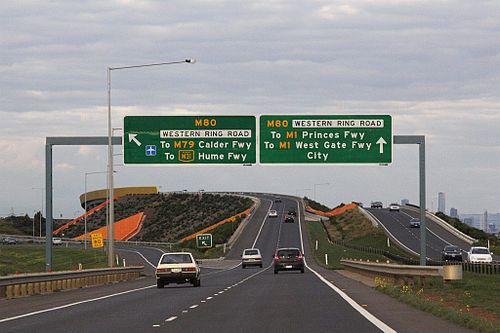 Deer Park Bypass on the Western Freeway
 The Tasman Highway in Tasmania


New Zealand


The term motorway in New Zealand encompasses multilane divided freeways as well as narrower two- to four-lane undivided expressways with varying degrees of grade separation; the term motorway describes the legal traffic restrictions rather than the type of road.[170]
New Zealand's motorway network is small due to the nation's low population density and low traffic volumes making it uneconomical to build controlled-access highways outside the major urban centres.
New Zealand's first motorway opened in December 1950 near Wellington, running from Johnsonville to Tawa. This five-kilometre (3.1 mi) motorway now forms the southern part of the Johnsonville-Porirua Motorway and part of State Highway 1.[171] Auckland's first stretch of motorway was opened in 1953 between Ellerslie and Mount Wellington (between present-day exit 435 and exit 438), and now forms part of the Southern Motorway.[172]
Most major urban areas in New Zealand feature limited-access highways. Auckland, Wellington, Christchurch, Hamilton, Tauranga, and Dunedin contain motorways, with only Auckland having a substantial motorway network.
See also
Notes
- ^Used in the western part of the United States, parts of Australia, parts of Canada, and South Africa.
- ^Used in the United Kingdom, Hong Kong, Ireland, Pakistan, New Zealand, and parts of Australia.
- ^Used in parts of the United States, parts of Canada, Australia, China, India, Japan, the Philippines, South Korea, and an official term in the UK and Hong Kong. In some parts of the United States, this also designates a type of limited-access road of lower class than a freeway. In the UK it officially refers to main roads of a lower class than a motorway. Depending on the region, the term is also often applied to limited-access roads, sometimes combining them with controlled-access highways into a single category.[1]
- ^Columbia Guide to Standard American English: "Thruway is the Standard spelling of the word meaning a 'high-speed, limited access, multiple-lane highway. [...] Throughway is a variant."
- ^Portions of the Downtown Connector in Atlanta, Georgia, have eight lanes in each direction.
External links
 Media related to Controlled-access highways at Wikimedia Commons
สรุปเนื้อหา
ข้อมูลสำคัญจากบทความ
ข้อมูลสำคัญเกี่ยวกับ ทางหลวงที่มีการควบคุมการเข้าออก
ทางหลวง ควบคุมการเข้าออก คือ ทางหลวง ประเภทหนึ่งที่ออกแบบมาสำหรับการจราจรของยานพาหนะความเร็วสูง โดยมีการควบคุมการไหลของจราจรทั้งหมด ทั้งขาเข้าและขาออก...
มาตรฐานคำจำกัดความ
มีมาตรฐานสากลหลายฉบับที่ให้คำจำกัดความของคำต่างๆ เช่น ทางหลวง แต่ไม่มีคำจำกัดความอย่างเป็นทางการของคำในภาษาอังกฤษ เช่น freeway , motorway และ expressway หรือคำที่เทียบเท่าในภาษาอื่นๆ เช่น autoroute , Autobahn , autostrada , autocesta, autoput...
ประวัติศาสตร์
ทางหลวงควบคุมการเข้าออกสมัยใหม่รุ่นแรกพัฒนาขึ้นในช่วงครึ่งแรกของศตวรรษที่ 20 ทางหลวง Long Island Motor Parkway บน เกาะลองไอส์แลนด์ รัฐ นิวยอร์ก ซึ่งเปิดในปี 1908 ในฐานะโครงการเอกชน ถือเป็นทางหลวงควบคุมการเข้าออกแห่งแรกของโลก...
ออกแบบ
ตามนิยามแล้ว ทางหลวงพิเศษไม่มี ทางแยก ที่ระดับพื้นดิน กับถนนอื่น ทางรถไฟ หรือ ทางสัญจรอเนกประสงค์ ดังนั้นจึงไม่จำเป็นต้องมีสัญญาณไฟจราจร และโดยปกติแล้วรถที่วิ่งบนทางหลวงพิเศษไม่จำเป็นต้องหยุดที่สัญญาณไฟจราจร อย่างไรก็ตาม บางประเทศ เช่น สหรัฐอเมริกา...